DCWW Coastal Investigations Programme (2017)
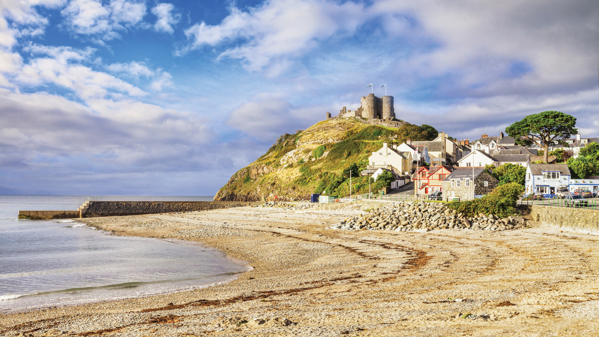
Figure 1: Criccieth Beach in Tremadog Bay - Courtesy of DCWW Capital Delivery Alliance
In March 2015 Dŵr Cymru Welsh Water (DCWW) launched the biggest Welsh coastal investigation and modelling project ever undertaken to enhance its understanding of the factors affecting water quality at 49 sites (29 bathing waters and 20 shellfish waters) along the entire Welsh coastline. The evidence gathered from this study will allow DCWW to assess the impact of its sewerage assets at these sites and establish whether further investments are required to upgrade its infrastructure to meet the latest environmental standards. The work will also enhance DCWW and other parties’ ability to contribute to the resilience of marine ecosystems. As well as mathematical modelling, the two-year £8m programme included oceanographic surveys and water quality monitoring in rivers, beaches, surface water drains and sewers. The project has provided DCWW and its regulator, Natural Resources Wales (NRW), with analysis and tools that will help to better understand and protect Wales’ coastal waters for years to come. The project also sets the scene for further research DCWW will support in 2020-25.
Background
The Coastal Investigations Programme was commissioned by DCWW to assess what effects water quality at 49 sensitive receiving waters, namely 29 Bathing Waters (BW) and 20 Shellfish Waters (SFW), along the Welsh coastline. The objective was to:
- Identify which sources of pollutants are the largest contributors to water quality issues at each of the 49 sensitive receivers.
- Determine what measures, e.g. asset improvement, catchment management, reduction in misconnections, could deliver Excellent class in BWs or the WFD Guideline standard in SWs
- Inform DCWW’s Price Review 2019 (PR19) for future asset management investment e.g. to further improve coastal combined storm overflows.
This project has enabled DCWW to prioritise actions and investments during AMP7 that will further improve the coastal waters by understanding the impacts their assets and other contributors have. The largest study of its kind in Wales covers 1700km of coastline, including more than ten major estuaries, over 900 assets and 70 sewer network models. The 49 sites therefore have a wide range of factors contributing to local water quality.
Sites were in both urban and rural areas, some of which are heavily influenced by seasonal tourism. Interestingly, some catchments had high numbers of private or trade sources; and large contributions from diffuse sources such as agriculture, livestock and wildlife, in addition to DCWW assets. Impacts were assessed against the appropriate standards, namely the revised Bathing Water Directive (rBWD) for BWs and the appropriate sections of the Water Framework Directive (WFD) for SFWs.
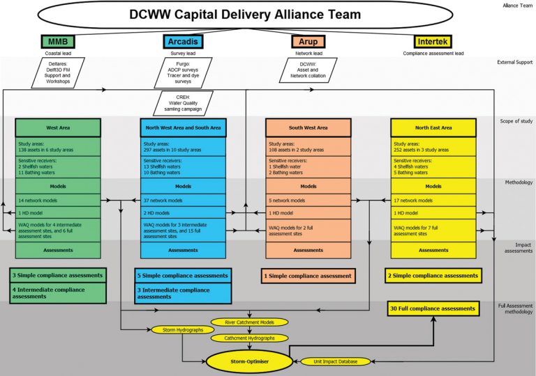
Figure 2: Structure of the Capital Delivery Alliance, key work flows, and methodology – Courtesy of DCWW Capital Delivery Alliance
Alliance team
The Alliance Team (AT) assembled to undertake this ambitious project consists of three partners Mott MacDonald Bentley (MMB), Morgan Sindall/Arup (Arup), and Skanska/Arcadis (Arcadis), supported by Intertek Energy & Water Consultancy Services (Intertek) and a survey team comprising APEM, CREH and Fugro.
Each AT partner brought unique expertise to the project, and collaborated in undertaking the work towards this challenging and exciting common goal. With collaboration on this scale, covering multiple locations, disciplines and interlinked critical pathways, a high degree of coordination and leadership was required. A stylised summary of the work flows and key expertise can be seen in Figure 2 (above), and geographical division of work can be seen in Figure 3.
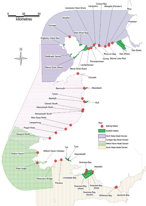
Figure 3: Output areas – Courtesy of DCWW Capital Delivery Alliance
Compliance assessments
The Coastal Investigations Programme began with an initial scoping study, reviewing each of the 49 sites. This included a review of all available information on each BW and SFW, together with a high-level study of the routine sampling data. A correlation analysis of Water Quality (WQ) sampling data was also undertaken against historical environmental data for meteorological conditions, such as rainfall and wind speed and direction, and hydrodynamic conditions, such as tidal stage and river flow.
Based on outputs from these initial scoping studies, each of the 49 sites was assigned a level of assessment (Simple, Intermediate, Full) depending on the number of potential sources, local complexities, and performance history at each site. A methodology for each assessment type was developed in consultation with NRW, each with separate supporting components such as survey work, coastal modelling, and network modelling and hydrograph generation.
The Simple Assessment Methodology was applied at sites where the main cause of pollution was largely understood, but needed to be verified. These sites were assessed based on historic data, new water quality data, local knowledge, and previous assessments (where applicable). The Intermediate methodology considered sites of relative simplicity and a limited number of DCWW assets, and where the coastal models have been used to assess impacts from sources further afield. Full assessment sites utilised a full WQ statistical database created using an 11-year hydrograph from network models and 28 different hydrodynamic scenarios generated in the coastal models for each asset. This was undertaken in Intertek’s in-house STORM-OPTIMISER software, to reproduce the historic baseline for calibration, and simulate future scenarios.
Alongside the formal compliance assessment undertaken for each site, the PR19 tool was developed to provide asset managers and investment planners with a fast and easy method to obtain an overview over a specific site or area. This tool was populated with information about each asset’s ability to impact water quality at the sensitive receiver. Each asset was scored based on the level of investigation or capital work required to meet water quality standards. This tool will help DCWW understand and target investments where they will be most beneficial.
Methods
An extensive field survey program was undertaken to provide supporting information to this study driven by outcomes of the scoping phase. CREH and FUGRO EMU, led by APEM, carried out source sampling and oceanographic surveys. The data collected was used in several phases of the Coastal Investigation Programme – the oceanographic survey data were used in the calibration and validation of the coastal models against measurements of tides, currents, and salinity at locations around the coast. Microbial tracer surveys were also undertaken to ensure that the coastal models accurately represent advection-dispersion processes. Water quality sampling data was collected to support a wider understanding of catchment processes and the sources of pollution. This information was used in the compliance assessments to ensure that representative bacterial loads are used for each source, with streams, rivers and key assets sampled in all study areas. A total of 20,000 environmental samples were taken across 55,000 hours of nearshore surveys to understand contributing loads of pollution under dry and wet weather conditions.
Around 900 assets were analysed through a combination of models, local knowledge, historic and bespoke data. A total of 73 hydraulic sewer network models were made available for the study, which were used to gain a greater understanding of local network systems and asset performances within each of the 21 study areas. Where network models were not available, suitable donor models were identified. Network modelling outputs and telemetry data was interrogated to identify typical intermittent discharge frequencies, durations, and volumes. To enhance each AT partners understanding of their study areas, regular meetings with local operations managers and key workers at both DCWW and NRW were undertaken, to share knowledge and align understanding of network performance.
Coastal models were created for each of the five output areas using the Delft3D Flexible Mesh modelling suite recently developed by Deltares. These were built and maintained by each of the AT team partners. Overlap between model areas was ensured to ensure adequate coverage for all currently designated bathing waters in Wales. This was to ensure that the models can be easily adapted for future use, should DCWW wish to investigate further sensitive receivers, or if the local conditions should change. Coastal models were used to simulate coastal hydrodynamics under a range of tidal, wind and river flow conditions.
The Full and Intermediate Compliance Assessments utilised detailed modelling of the pollutant load in the coastal models, using the water quality module of Delft3D. These models assessed pollutant release at all states of the tide from each asset source, and assessed the modelled pollutant levels at the sensitive receivers. The models incorporated processes such as decay, and dispersion of pollutants through the action of the tide and wind. This created a database of 28 hydrodynamic conditions for each source location, released for 12 states of the tide, creating a total 336 scenarios for each source against which the transfer of pollutants within the coastal zone could be investigated.
Intertek undertook Full Compliance Assessments in each of the five model areas, using their STORM-OPTIMISER software and the outputs produced by all AT partners. This software has been used extensively for similar studies in Wales, England, and Scotland, and has been accepted previously by NRW, the EA and SEPA. The STORM-OPTIMISER software evaluates the impact of continuous and intermittent discharges on the BW and SW receivers. It allows the Full Assessment of bacterial impacts from multiple sources under a range of environmental conditions (e.g. tide and wind frequency conditions) and the impact of all point and diffuse sources are assessed to determine which discharges are most significant.
The STORM-OPTIMISER software was calibrated at each of the Full Assessment sites for the preceding 11 years using historic monitoring data at the BW and SW sites. Inputs to the STORM-OPTIMISER software included an 11-year simulation of each asset, provided by the network models, and the water quality simulations from the coastal models for the full range of environmental conditions assessed, to ascertain the pathway between source and receptor. For a schematic illustration, see figure 4.
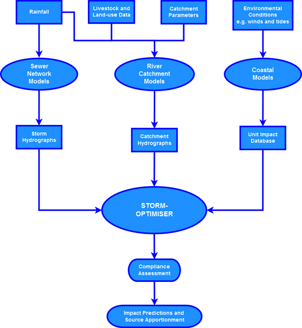
Figure 4: Schematic illustration of Storm-Optimiser workflow – Courtesy of DCWW Capital Delivery Alliance
Innovations
A collaborative project on this scale covering multiple locations, disciplines, consultants, and objectives requires a high level of coordination and leadership. The AT achieved this through applying the collaborative planning approach to planning, driving and monitoring progress, ensuring knowledge sharing, target deliveries were met, and that workloads were distributed evenly throughout the project. Over 40 people have been working on the project throughout, putting in over 103,000 work-hours without a single reported injury or serious near miss incident.
At the start of this project the AT was one of the first consultants worldwide to utilise the newly developed Delft3D Flexible Mesh software and hydrodynamic engine from Deltares. To accommodate this, Deltares provided a training course for the AT partners in Cardiff. This not only enabled the modellers from the AT partners to become familiar with a new piece of software, but also to become familiar with each other, which enhanced the teamwork throughout the project. The Delft3D FM software suite and collaboration with Deltares have been instrumental in ensuring quality and timeliness of deliverables throughout this project.
The AT partners’ hydrodynamic modellers utilised a novel method of ensuring consistency and coherency throughout the five separate model domains. This included a uniform approach to the derivation of spatially varying maps for dispersion coefficients. This method relies on modelled flow velocities and depths combined using the method developed by Gao et al. (2013), to create bespoke dispersion maps for each of the model areas. This method was found to be highly efficient, and only a few manual edits were required throughout the model domains. An example of one of these dispersion maps can be seen in Figure 5.
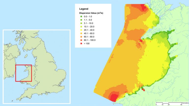
Figure 5: Dispersion values map: West Coast – Courtesy of DCWW Capital Delivery Alliance
Some full assessment sites required over 600 model runs to simulate all possible conditions. As the models required a high spatial and temporal resolution to fully resolve the local conditions, the simulation time required for some of these study sites became over 15 hours per simulation, which created a significant pressure to processing capacity in the delivery timescale. To accommodate the high level of accuracy and number of runs needed, cloud computing was utilised to reduce the run time. For some domains, this meant that run time was reduced from 6 months to 6 weeks using more than 120 virtual computers to automatically progress through required runs, with an accumulated run time of more than 1000 computer days.
Conclusions
This was a truly multidisciplinary study. Upon the successful completion the AT was able to provide DCWW with a cost-efficient tool for asset management, and NRW with an enhanced and detailed understanding of WQ issues through 49 compliance assessments. A summary of the findings can be seen in Table 1. This was made possible through dedicated teams undertaking a vast range of work involving literature, model, and data reviews; extensive sampling campaigns; data analyses; and network, hydrodynamic, and water quality modelling. The outputs from the study were delivered on time due to the constant drive for excellence and innovation throughout the Capital Delivery Alliance Team.
Although Wales currently achieves the highest Excellent bathing water class at 82 of its 103 designated beaches, and the majority of shellfish waters meet the Long Term B class, the study is helping DCWW identify where future investment could deliver further improvement. Table 1 provides a summary of the preliminary study findings, in terms of where future investment could deliver further improvement to the coastal environment while maintaining affordable bills for DCWW’s customers.
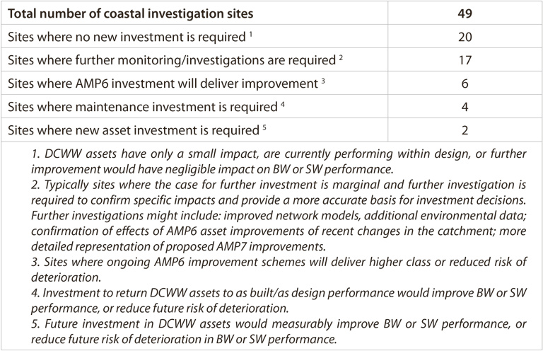
Table 1 Preliminary Study Findings
The study has currently identified only two sites where future investment by DCWW would deliver significant improvement in receiving water quality at affordable cost. This is typically because water quality is determined by factors not within DCWW’s control, such as diffuse pollution, or recent catchment improvements delivered by DCWW, NRW and local authorities has delivered improved environmental performance. The findings will allow DCWW to make investment decisions for PR19 with greater certainty, providing significant cost savings to DCWW and its customers.