
Leeds Flood Alleviation Scheme (2016)
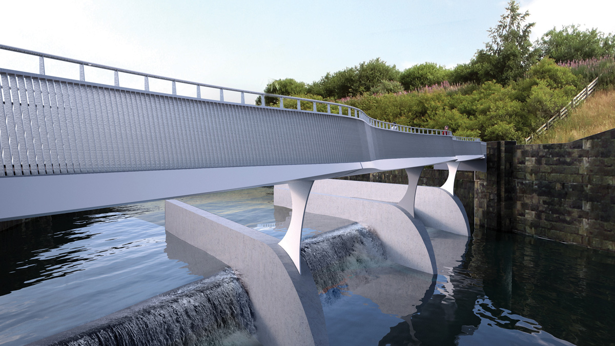
Visualisation of the Knostrop Weir footbridge - Courtesy of Knight Architecture
Historically, Leeds has not benefited from formal flood defences and is sited in a catchment where the river can rise rapidly in response to rainfall. There are records of flooding dating from the 19th century and in the recent past; prior to the scheme commencing the river had come close to flooding Leeds city centre on four occasions since 2000. To address this, the Leeds Flood Alleviation Scheme is providing 1 in 75 year protection to 3,000 homes and 500 businesses in Leeds city centre from fluvial flooding from the River Aire and Hol Beck. The scheme includes linear defences comprising masonry clad concrete walls and glazed panels along the river through the city centre. In addition, innovative moveable weirs are being installed at Crown Point and at Knostrop and these can be lowered in flood conditions to reduce river levels. The Knostrop Island is also being removed to increase the capacity and conveyance of the river downstream.
Project delivery
The scheme is being delivered by BMMJV; a joint venture between BAM Nuttall and Mott MacDonald based on a reference design prepared by Arup for Leeds City Council. The Environment Agency is closely involved with the scheme and Leeds City Council made use of its WEM Framework to procure the design and construct contract.
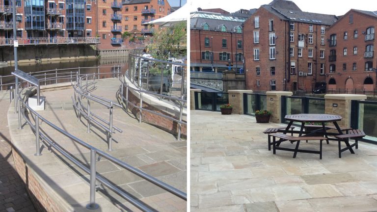
(left) Centenary Bridge – Riverside walkway permitted to flood but properties protected by ramp and (right) glazed panels provided at Dock Street to preserve river view – Courtesy of Mott MacDonald
Linear works
The scheme protects properties along some 4.3km of river from Leeds Railway Station to Knostrop Canal Basin. Along this length some existing structures provided suitable protection but many defences through the city centre needed to be raised to contain the peak modelled water levels. Where possible, flood defences were set back from the river’s edge to maintain amenity of the riverside frontage. For example at Centenary Bridge ramps and steps were incorporated into the landscaping of a public space without appearing to be an obvious flood defence. Importantly none of the linear works through the city centre are higher than 1.5m and the majority are at 1.2m or lower, maintaining connectivity with the river for passers-by.
The scheme contains a variety of different wall raisings, each selected to suit the local conditions. A typical detail is a reinforced concrete wall clad with masonry to suit the surrounding buildings. These walls are founded either as ‘L’ sections to utilise the backfill behind the wall to found the wall; or where existing river wall conditions permitted, by coring into the existing structure and bonding the new wall to the old.
Where the walls were being positioned in front of existing river views, glazed panels were specified. These required careful design and detailing to ensure the cast-in fixings aligned with the concrete reinforcement.
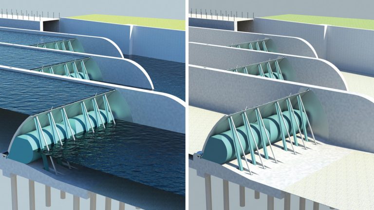
Weir – square on – Courtesy of Mott MacDonald
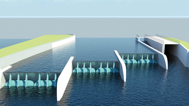
Movable weirs
There are several historic weirs on the River Aire through Leeds that have evolved to facilitate industry and maintain water levels for navigation. To increase conveyance and reduce flood levels through the city centre, the fixed weirs at Crown Point (in the city centre) and Knostrop (2km downstream) are being removed and replaced with moveable weirs that can be lowered to reduce river levels during flood events whilst maintaining navigable depths in normal conditions.
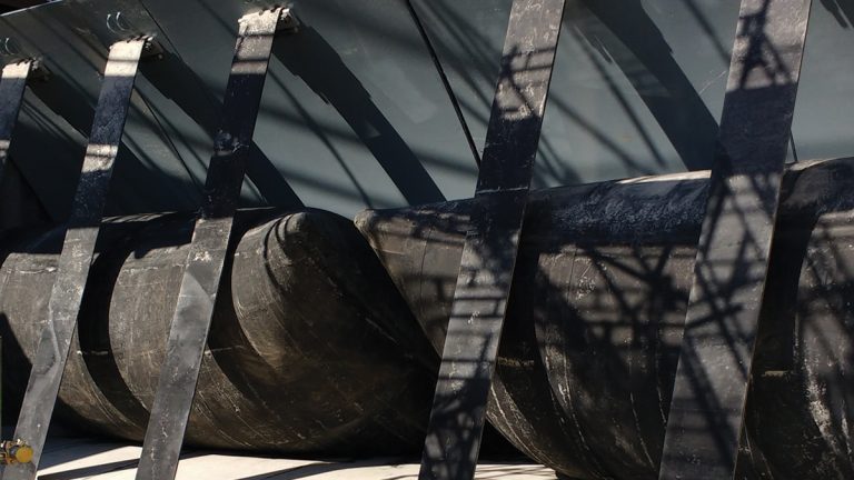
The weirs are supplied by Dyrhoff. They comprise steel plates hinged to a concrete foundation and supported by a number of inflatable rubber bladders. The weir plates sit within concrete channels cast to tight tolerances in the river channel. Each weir is supplied with compressed air piped from an adjacent control building housing compressors and valve cabinets. To ensure safety of boat and other river users, the weir lowering sequence will be initiated manually and take place over a number of hours.
Fish, eel and otter passes are being constructed alongside the new weirs to enhance the ecology of the river through the city. Each weir has a larinier fish pass to permit upstream movement and a fish bywash for downstream travel.
The weir at Knostrop is the first to be constructed and will also be the first to be operated when storm flows are forecast. The weir at Crown Point will then be lowered shortly after.
Knostrop Weir under construction – Courtesy of BMM JV
Knostrop Cut Island and relocation of Trans-Pennine Trail
The Knostrop Cut Island is being removed as part of the scheme. The island previously separated the river from the Aire and Calder Navigation. Taking away a 600m length widens the river channel, providing storage and improving conveyance of water away from the city centre.
The island used to carry the Trans-Pennine Trail, a popular walking and cycling route. To mitigate for the loss of this facility, a new route is being established on the northern bank of the river and a new landmark footbridge is being established over the new moveable weir at Knostrop.
The new route has been landscaped to provide an attractive path for users, but also to create habitat along the riverbank.
Testing times
Construction of the scheme started in January 2015. To ensure flood risk did not increase as a result of the construction, the works were sequenced in a manner that would not obstruct flood conveyance down the river. For example before removing the existing weir at Knostrop, a temporary weir was constructed upstream at the same crest height to maintain existing river levels. In addition the temporary cofferdams installed in the river were designed to flood during significant events to avoid exacerbating flooding upstream.
The need for the scheme was clearly demonstrated during the winter of 2015 when the Leeds was hit by a series of significant flood events. The most serious was on 26 December when waters in the River Aire reached levels 1.2m above their previously recorded high and widespread flooding occurred.
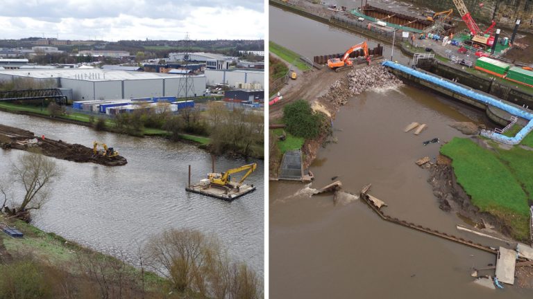
(left) Removal of Knostrop Cut Island and (right) emergency repairs to the canal bywash breach at Knostrop – Courtesy of BMM JV
Emergency works
BAM Nuttall employees interrupted their Christmas festivities to visit Leeds at the peak of the floods to assess the impact to our work areas on our project. During the second visit it was discovered that the by-wash channel at Knostrop lock, which is adjacent to the works being carried out to install a new movable weir, had failed, the canal bank had breached and several canal boats that had been moored in the area had been washed away. An emergency works response team was put together with plant mobilised to site the following day in order to place a rock berm across the breach.
(left) Weir view and (right) weir view no water – Courtesy of Mott MacDonald
Rock and broken concrete from the old weir was placed in the fast flowing waters and by the 31st December the river waters entering the canal system had been reduced to an acceptable level.
On January 4th the piling team was mobilised to install a sheet piled wall across the breached area to provide a more substantial solution to the problem, allowing Leeds City Council, Environment Agency and Canal & Rivers Trust to work up a permanent repair solution.
The site team was assisted in this works, calling on supply chain partners Aggregate Industries for stone, Thorne Demolition and Sweetings of Leeds for excavators and transport to help us successfully complete the emergency repairs.
Elsewhere staff were also in action to recover the canal boats and barges, bringing them to a safe location.
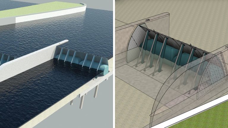
(left) Weir – wide angle view and (right) weir with transparent wall – Courtesy of Mott MacDonald
Conclusion
Constructing the scheme has been challenging working on multiple sites in a highly visible location. Despite this and the storms of winter 2015, the scheme is on track for completion in March 2017. Following this Leeds will have formal flood protection from the River Aire and Hol Beck that will give confidence to the local population and future investors in the city.