
River Thames Scheme (2018)
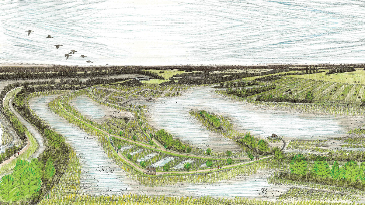
Artist’s impression of the proposed Abbey wetlands centre; this is being created to provide environmental mitigation for the scheme - Courtesy of Black & Veatch, enplan, Environment Agency
Big problems require bold solutions. That is what the Environment Agency (EA) is proposing with the River Thames Scheme. The EA is tasked with protecting one of the most developed, yet undefended, flood plains in England – the River Thames between Windsor in Berkshire and the western fringes of greater London – an area with a long history of serious flooding. It is estimated that a major flood now would put almost 15,000 homes and 2,400 commercial properties at risk and jeopardise their electricity supply and sewerage services. Disruption to local roads and railway lines would be significant, in addition to affecting nationally important infrastructure including the M3, M25 and Heathrow Airport.
Background
Central to the EA’s flood alleviation strategy, the River Thames Scheme is to design and construct a 14.5km-long flood channel ranging 30-60m in width. The channel will be in three sections and, along with enhancements to three weirs, is expected to cost circa £500m. Flood risk for up to 15,000 residential properties and 100,000m2 of commercial floor space will be reduced as a result. Protection for 300km of local arterial roads and railway lines at risk of flood will be enhanced significantly. The risk of disruption for Heathrow and the M3 and M25 will lessen greatly. In addition, the scheme will create amenities for the communities along the new channel’s course.
Appraisal strategy
With the strategy agreed, the second phase of the project – completion of the appraisal study – is now coming to fruition. This phase of the project has been undertaken by designers and consultants from Black & Veatch (now Binnies), working as part of the GBV joint venture between Black & Veatch and Galliford Try.
The appraisal encompasses the following, effectively creating the project’s business case:
- Outline design.
- Design optimisation.
- Scoping costs.
- Scoping environmental impacts.
- Ensuring compliance with environmental directives such as the Habitats Directive and Water Framework Directive.
In developing the project Black & Veatch has carried out extensive public consultation.
Terrain
The scale of the project, and the terrain through which the channel is routed, presented the River Thames Scheme appraisal’s primary challenges. There is very little natural ground along the proposed route, the channel will run predominantly through former landfill sites and lakes.
This unfavourable terrain, however, afforded the appraisal team the opportunity to propose several enhancements to the original strategy. The strategy design assumed all of the material excavated from the disused landfills would need off-site disposal, at a cost of £108m.
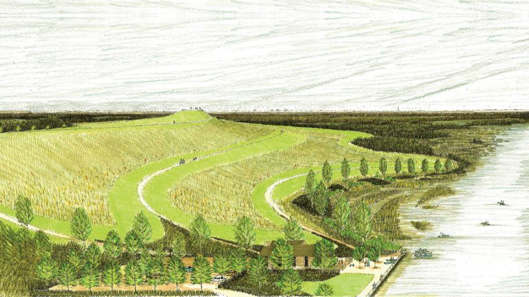
Artist’s impression of Sunnymeads Country Park, a landscape enhancement – Courtesy of Black & Veatch, enplan, Environment Agency
Sustainability
The appraisal team put sustainability at the project’s heart, prioritising materials management within the design process, and developing a materials management strategy that minimises the volume of excavated material, maximises the reuse of excavated material and minimises the amount of material taken off site.
They used analysis of more than 100,000 laboratory test results to characterise the ground along the channel route and enable a detailed assessment of contamination levels. This data supported the reuse of material on site.
In addition, the team held workshops with contaminated land specialists to discuss mechanisms to reuse former landfill material in compliance with planning and other regulatory requirements. In this way they helped demonstrate to the client the legal compliance of the reuse strategy.
One example of the materials management strategy delivering benefits was rerouting the main channel to avoid the Wraysbury landfill. Site investigations showed the presence of medical and domestic waste in the landfill which would need excavation, removal and disposal at a new location had the channel gone through the site. Rerouting the flood channel through adjacent land meant an 800m section of the landfill could remain undisturbed. This saved 150,000m3 of material from transportation to an alternative landfill; cutting tax liabilities and vehicle movements.
Where excavation of landfill is unavoidable the material will, if possible, be reused on site.
This approach led to the plan for a series of raised landforms or ‘beacons’ which highlight and celebrate the line of the new channel. The four beacons (10-20m high) are an example of integrating public amenity into the form and function of the design.
In total, work to minimise the channel volumes passing through former landfills reduced the length of the channel by 3.5km; with attendant savings in cost and construction risk and time. The material management strategy will cut the amount of material going to landfill percent to just 4%, reducing the original estimate of a £250m landfill tax liability to £8m, and reducing the environmental impact of hauling material and the associated carbon footprint.
The scale of the project, coupled with the challenging terrain, resulted in a sizeable programme of investigation and modelling.
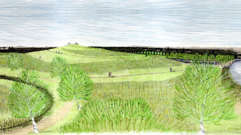
Artist’s impression of the Royal Hythe landscape enhancement area on channel section 2 – Courtesy of Black & Veatch, enplan, Environment Agency
Ground conditions
Determining the ground conditions along the channel’s proposed route required sinking more than I,000 boreholes. A 3D ground model was created for the entire 17km of the original strategy design route. Feeding into this were major topographic and bathymetric surveys; the latter to determine the bed levels of water bodies along the proposed route.
The scale of the task led the company producing the 2D hydraulic model to put the delivery date back by 12 months. To try and minimise the impact of this upon the programme schedule Black & Veatch’s team used a simplified one-dimensional model to allow conceptual work to progress until the two-dimensional model became available and could be refined. Developing an alternative, improved, hydraulic design negated the need for one section of the channel; avoiding the challenges posed by the Dumsey Meadow Site of Special Scientific Interest.
CFD modelling
Another way in which the appraisal team was able to add value was through the use of computational fluid dynamics (CFD) modelling. The original scope required physical models of the weirs. The appraisal team was able to instill the EA with confidence that CFD could be as effective as physical models, while allowing designs to be optimised in a way not possible with physical models. CFD modelling offered the chance to test multiple options by allowing designs to be amended and different scenarios run.
While physical models are destroyed after use, CFD models offer the additional benefit of creating an interrogatable legacy database which can be of significant value in the detailed design phase. Speed was a further benefit of using CFD modelling, which was two to three months faster, per weir, than physical modelling. Overall the appraisal team estimates a £1m cost saving by adopting CFD. The approach also enabled the team to design-out operational hazards. For example, the original design for one weir called for a stilling basin; empty during normal flows but intended to contain fast flood flows in order to minimise damage caused by scour.
Through CFD modelling, the team was able to demonstrate the stilling basin was not required, removing a potential hazard.
A further example of CFD modelling improving the safety of the design is the design of the weirs. Weirs have the potential to form a dangerous undertow in the area downstream. Undertows are hazardous as they tend to trap objects (or people) below the surface of the water. CFD was used to optimise the geometry of the weirs to ensure that undertows would not be formed.
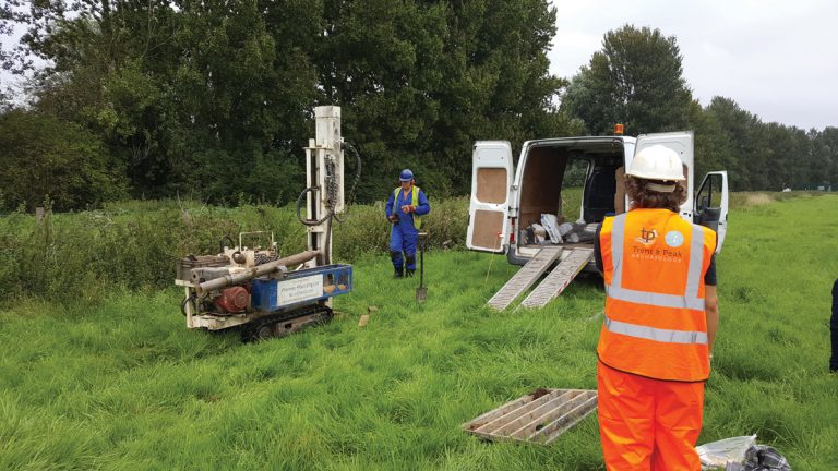
An archaeology survey in progress – Courtesy of Black & Veatch and the Environment Agency
Integrated design/build team
The ability to remove risk and add value during the appraisal stage was enhanced by the Black & Veatch team’s ability to draw upon the construction expertise of their GBV joint venture partners Galliford Try.
An integrated design/build team helped provide consistent cost estimates for civils work, and ensured buildability was a consideration throughout the design, not just at key points requiring major civils. Calculating the number of HGV movements that could be avoided by reducing the amount of excavated landfill that would have to be taken off site was another area in which the access to construction expertise was invaluable.
This collaborative approach extended to the appraisal phase’s stakeholder engagement programme. A major element of the appraisal was to give stakeholders confidence that creating a major artificial water course through a terrain of lakes and landfill would not affect negatively surface and ground water quality.
As a result the aim was not just to inform stakeholders about plans, but actively engage them in the project. This was achieved by setting up discussion groups for the Berkshire and Surrey sections of the scheme. The 50-strong groups brought together landowners, Natural England, wildlife groups, residents groups and local government.
Consensus building
Working across three sessions the discussion groups ranked proposals, shared views and then provided feedback upon earlier sessions. The aim was to garner public support and win over objectors by building consensus.
The consensus building was especially effective in situations where a decision had to be reached between two equally viable options. Work to increase the River Thames’ capacity at Desborough Cut, for example, could be undertaken on either the north or south bank.
Involving the consultation group in the decision making meant that the option with the greatest public support, the north bank, was selected.
The consensual approach also gave the appraisal team confidence to pursue the reuse of landfill materials in a creative manner. Initial proposals were to disperse the material widely at low level; to lessen visibility. As public confidence in the scheme increased the beacon concept became a viable, more engaging, option.
Further evidence of the scheme’s collaborative nature is the hosting of EA professionals at Black & Veatch’s main UK office, in Redhill, Surrey. On most days significant numbers of the EA’s River Thames Scheme team are working alongside Black & Veatch’s appraisal team in Redhill.
Current status
The appraisal document is nearing completion, and this will make the case for investment to secure funding for the project’s construction. The next major phase will be the preparation of the environmental impact assessment and planning application.
To date this bold solution to a major challenge is proving a showcase for sustainability and helping the EA deliver multiple benefits.