
Salcombe Sewer Flood Alleviation (2016)
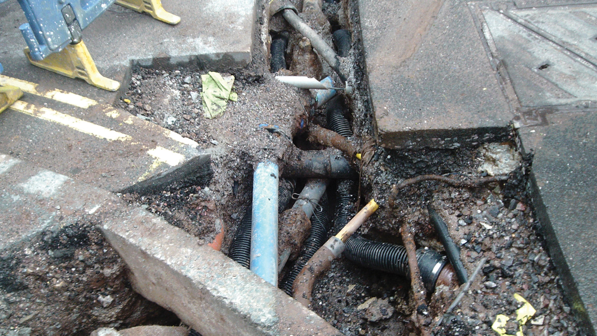
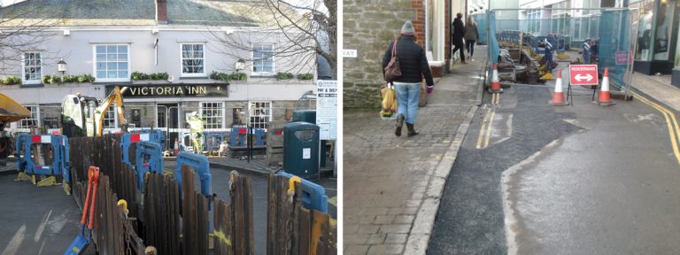
Utilities congestion at the junction of Fore Street and Robinsons Row - Courtesy of SWW Delivery Alliance H5O
Salcombe is a popular tourist town in south Devon with a resident population of 2,500 and a peak tourist population of 3,300. The main one-lane street becomes packed with holiday makers and second home owners in the summer months. The main town area is low-lying and runs alongside the Kingsbridge Estuary, although interestingly there are no main rivers attributed to this estuary. There are no rivers, streams or watercourses in Salcombe; the nearest being the Batson Creek to the north and the creek at North Sands to the south. Apart from two short lengths of surface water sewer in the town, constructed in 1995 to take local highway runoff, there are no other surface water sewers; hence all rainfall runoff across the catchment drains to the combined sewer network. This article describes some of the history of the sewerage system before summarising the optioneering work that concluded with the proposed £1.47m surface water separation project.
Background
The sewerage system has progressed through the decades. Originally there were 19 (No.) outfall pipes (clay and cast iron) discharging crude sewage straight to the estuary. The remains of these can still be seen at low tides. In 1974 an 18” cast iron collector sewer was built along the foreshore, just above MLWS with minimal cover and concrete surround. This picked up the 19 (No.) crude outfalls and discharged them at a single location at the seaward end of the estuary.
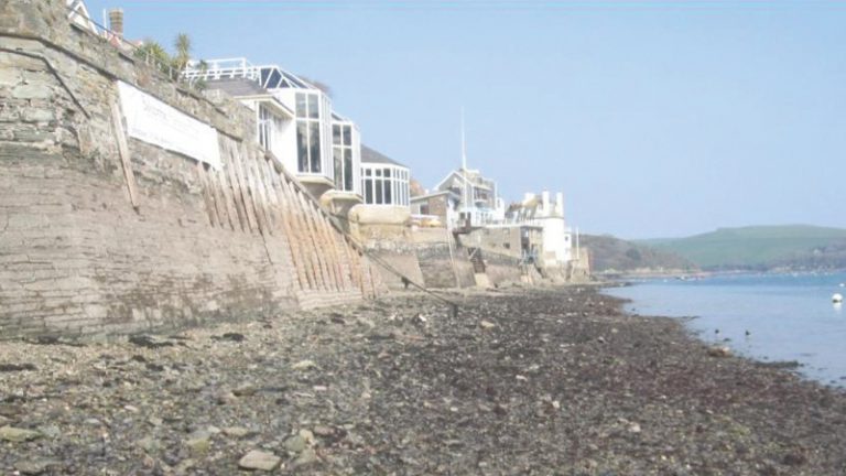
Typical foreshore area at low tide. Foreshore sewer below photographer – Courtesy of SWW Delivery Alliance H5O
A valve was fitted at the outfall that closed during a rising tide, preventing sewage washing up with the tide. Sewage flowed back up the foreshore sewer and was then pumped into two 600m3 tanks at Shadycombe, adjacent to Fish Quay. On a falling tide the outfall valve was opened and the tanks drained to the outfall.
In 1993 the Clean Sweep Programme addressed the crude discharge by constructing a 1m diameter tunnel from the outfall location to North Sands, diverting sewage into North Sands Pumping Station which then pumps sewage up to the treatment works, south of Malborough village.
The outfall valve has been retained and is used for saline balancing; an active system control which modulates the valve to keep the sewer level at a similar level to the tide in order to reduce the driving head and hence the inflow of infiltration into the sewer network.
Catchment plan
The lower town centre catchment drains into the foreshore sewer and on to North Sands pumping station. The larger upper catchment, above Devon Road, drains direct to the Shadycombe tanks via a combined sewer overflow and twin siphons. The tanks then drain into the foreshore sewer, controlled by an outlet valve.
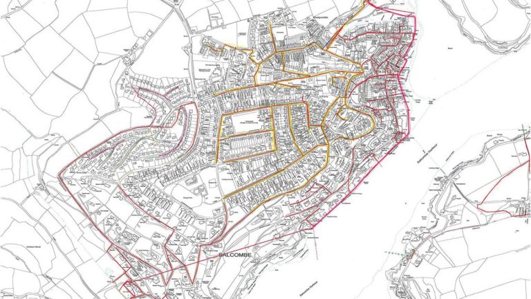
Upper catchment (yellow) and lower town catchment draining to the foreshore sewer (pink) – Courtesy of SWW Delivery Alliance H5O
There is a bifurcation in a chamber in Devon Road, whereby storm flows are diverted via a 450mm diameter sewer from the upper catchment direct to the lower catchment, connecting to the foreshore sewer.
There are a number of properties in the town centre lower catchment that have suffered both external and internal flooding from the combined sewer during rainfall. Some have been fitted with non-return valves, but this denies customers service when the valve is closed and just pushes flooding to the next lowest point. The aim of this project has been to reduce the flood frequency from yearly to 1 in 30 year events.
There was no hydraulic model of the Salcombe catchment, so in 2014 South West Water commissioned Pell Frischmann to construct a new Infoworks CS model. This was achieved by commissioning a catchment-wide impermeable area survey (IAS) that was carried out by Onspot Surveys Ltd, a local surveyor in the Devon area.
The IAS turned out to be a great tool in the optioneering and design phases of the project. Completed by hand this detailed which properties had been checked and which were assumed (20% sample rate in areas of similar housing), the direction of road runoff, all road gully locations and 100% sample rate in the important lower catchment town centre.
The IAS data was used to construct the sub-catchments within the model. The model was then verified using data from a small number of flow and depth monitors and also using SWW SCADA data collected at the main assets (CSOs, tanks, valve, pumping station and treatment works).
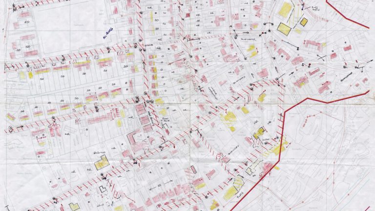
Sample from impermeable area survey (IAS) – Courtesy of SWW Delivery Alliance H5O
There is known saline infiltration into the sewerage system due to old pipe and manhole materials. Historically it would not have mattered if these leaked as the crude sewage would discharge to the estuary anyway. There is a separate ongoing phased project to locate and address the defects. The saline infiltration was modeled at a couple of locations as an orifice with a user-defined head-discharge curve that was calibrated to match depth data.
The saline balancing was not operational during the data collection, which made it easier to calibrate the modeled infiltration. The saline balancing was then modeled using the real time control in Infoworks CS.
The optioneering phase was the most complicated. Any wastewater engineer or modeler involved in sewer flooding or pollution projects, should not underestimate the effort and time needed to find solutions to these problems. Standard solutions were all attempted, including storage at certain locations, increasing pump rate, adjusting overflow levels and also resolution of saline infiltration and opening the saline balancing valve. None of these provided a feasible solution.
The solution was aiming for resolution of flooding during 1 in 30 year events. This constitutes various combinations of tide level return periods and rainfall return periods dependent on the joint probability.
Each catchment will have different vulnerabilities that mean that it could suffer flooding during either: intense rainfall events, long duration events filling tanks and systems, or some rainfall event combined with a high tide level causing tide-locking of overflows.
The main sewer flooding mechanism in Salcombe occurred during intense short-duration rainfall events with a lower tide level; so M30 rainfall was used with a tidal cycle peaking at 2.55m AOD with the tidal peak coinciding with the peak rainfall on the 60-minute event. Many modelers have used a constant high tide level for optioneering solutions but this is unrealistic and is likely to lead to over-engineered, unaffordable or infeasible solutions.
For any project, the modeler or engineer looking to resolve flooding should have a fundamental understanding of what exactly is causing the flooding and how this can be changed to improve the system. This may be incapacity of some sections of pipe, very high volumes of surface water entering the system, high levels of infiltration (both ground water and saline), tide-locking of overflows, overflows too high, overflow screen issues, high headlosses and restrictions, etc.
In Salcombe it became obvious that flooding in the lower catchment was due to the high flows coming from the Devon Road bifurcation during heavy rainfall. This flow was predicted to peak up to 550 l/s during 1 in 30 year events. This bifurcation was removed in the model and this showed that flooding would indeed be resolved (with some additional surface water separation in the immediate town centre area).
In order to remove bifurcation, in reality the flow must be diverted somewhere. The IAS identified that the impermeable areas in the upper catchment were mostly highways, with only small amounts of driveways and property roofs. So it was proposed to separate out the highways gullies into a new surface water/highways drainage system. This represented a total impermeable area of 3.3Ha.
It was possible to utilise the existing 450mm diameter bifurcation pipe, which runs from the bifurcation to the foreshore sewer, to carry the surface water and divert this straight to the estuary. This saved constructing a new outfall pipe in the busy narrow streets in the town centre. The existing combined sewer also navigated some narrow steps, so this was again used for the new surface water, and the combined sewer was extended in an area of easier build to divert the upper catchment’s foul sewage via an easier route.
(left) Whitestrand Car Park (Fore Street) 500mm diameter outfall trench and (right) Fore Street trench deviation – Courtesy of SWW Delivery Alliance H5O
In addition to the main surface water separation described above, separation was also carried out in the Fore Street area, diverting highways gullies and hence roof area draining to the highway, into a new 225mm diameter sewer and to a new outfall at Whitestrand car park. There was also optimisation of the saline balancing control valve, with addition of a rain detector to open the valve on heavy rain, as opposed to waiting until the foreshore sewer was at high level.
Construction
The resulting proposed scheme is currently being constructed and consists of approximately 2,243m of new surface water sewer, from 225 to 500mm diameter, 209m of new and upsized combined sewer, 51 (No.) new manholes and transfer 78 (No.) gully connections from a combined system. Two new surface water outfalls are being constructed, one on the re-utilised bifurcation pipe and the other at Whitestrand car park. The total cost of the scheme is £1.47m and it is due for completion in July 2016.
Construction of the project presented the team with a number of challenges to overcome, the first of these was to programme 20 road closures, some of which were complex and involved diversions around the main arterial route into the town.
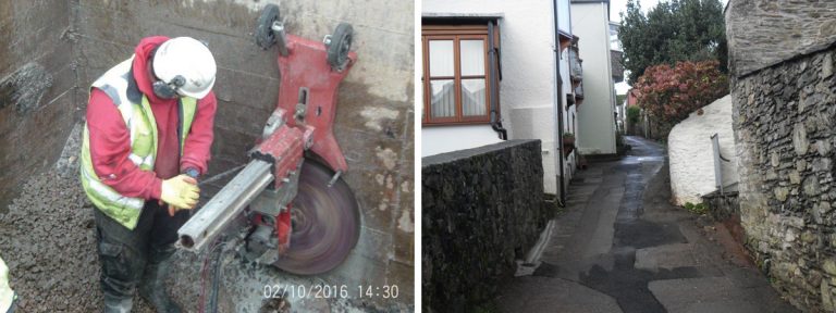
(left) 500mm core drill through headwall for pipe and flapvalve and (right) Robinsons Row after Reinstatement – Courtesy of SWW Delivery Alliance H5O
The team engaged with all stakeholders (Salcombe TC, South Hams TC, SW Highways, EA, Chamber of Commerce, utility companies, hotels, letting agents and the Harbour Master) to present the plan, explain the programme and clarify the measures that would be put in place to minimise disruption to businesses, residents and visitors. Evening question and answer sessions at the local rugby club were also organised. A shop in the town centre was leased and a customer liaison officer was allocated to the project to enable the team to focus on the construction. This proved very effective and no significant complaints or claims for loss of business were received.
Following project wide ground penetrating radar survey, the work commenced in November 2015 under a town centre road closure in the most challenging area Robinsons Row and Fore Street.
The streets were particularly narrow and heavily congested with converging 1st & 2nd generation utilities which meant that the majority of the trench was traditional hand excavation. Although trial pits were not conclusive we established a berth for the 500mm main in the carriageway with pragmatic, unconventional and innovative design changes to maintain line & level thus avoiding the requirement for time consuming utility diversions. Work through the Fore Street car park to install the 500mm storm outfall pipe through the jetty wall was difficult due to the subsurface being unstable made up tidal ground and constraints imposed on the MMO License by the EA.
Summary
The project is generally regarded a success by the client South West Water, and despite the significant design and construction challenges the team is on target to meet the programmed completion date of 15 July 2016, with minimal customer complaints and no claims for additional expenditure.