SUEZ Advanced Solutions UK Ltd
Satellite Leak Detection (2017)
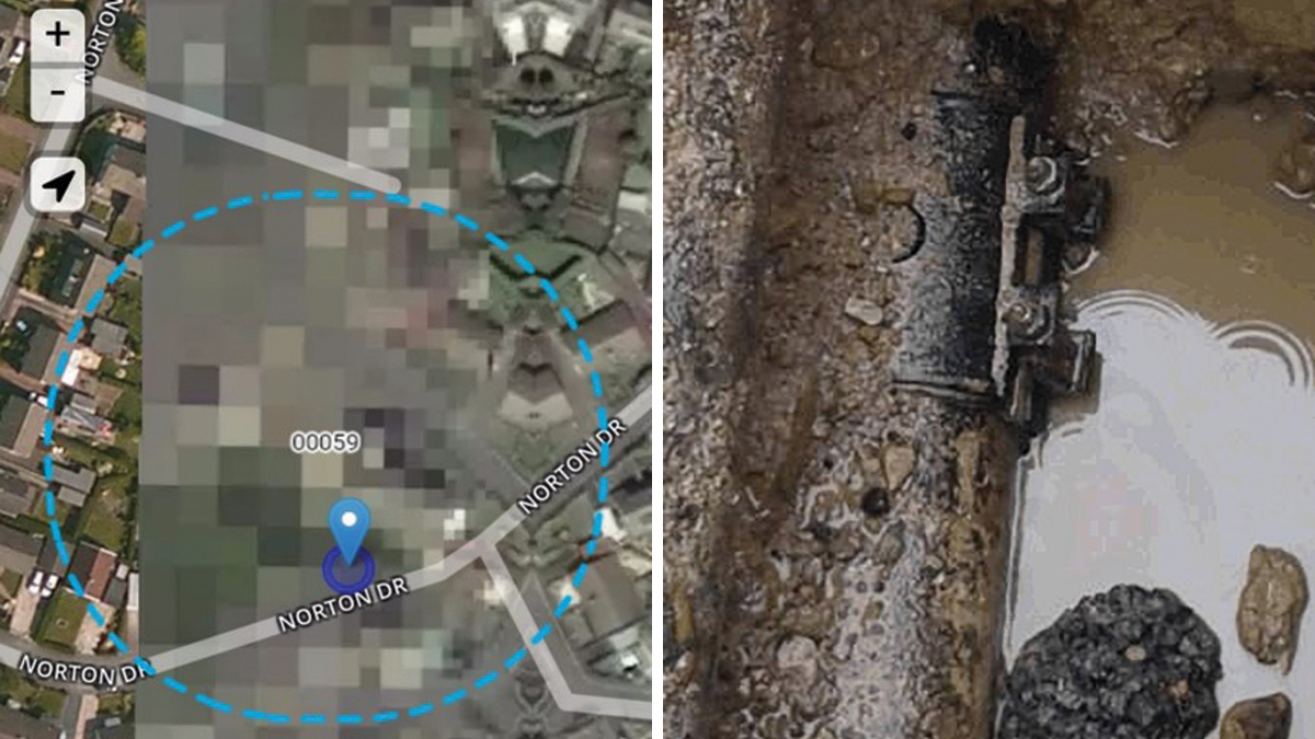
This screenshot shows the 100m radius that was targeted wherein the leak was found to be right in the centre. The detected leak that was later repaired
There is increasing pressure on water utilities to reduce their levels of leakage. The man-hour effort required to find and locate leaks only gets greater as network managers struggle to reduce leakage to lower levels. Costs associated with the treatment and distribution of water can be high and the penalties that utilities can face for missing leakage reduction targets set by Ofwat can also be high. Due to the rise in effort to prevent water loss through leakages, utilities are compelled to explore new methods of leak detection. One such method that some UK companies are now trialling is satellite leak detection.
What is satellite leak detection?
- Images are captured by using an existing satellite that searches for water on other planets. These images are then analysed by Utilis to detect leaks in urban distribution systems.
- The satellite-based methodology combined with onsite acoustic detection can dramatically increase the efficiency in which leaks are found.
- No installation costs, changes to existing infrastructure or capital expenditure are required. The entire system can be surveyed several times a year as opposed to just once every two to three years.
- The information can be provided periodically, on a monthly, quarterly or half-year basis and is presented on a graphic or tabular leakage report containing the locations of suspected leaks.
- By using this innovative method, utilities are quickly able to identify and tend to emergent leaks within their networks.
How did it start?
The idea of using remote sensors to find underground treated water started at the Hebrew University of Jerusalem. An Israeli scientist was conducting research for his thesis in geophysics and radiation transfers in the atmosphere by using microwave technology to find underground water on Venus and Mars.
As the technology showed indications of water on other planets, it was soon discovered that there was potential for locating water leaks on Earth, thereby helping to reduce NRW around the world. With its many successes, the technology continues to grow and currently has partners in 25 countries.
How it works
Images are acquired from a low orbit satellite that revisits the same points on earth every two weeks for recurrent analysis. Equipped with airborne-mounted sensors, the satellite is at an altitude where it can capture 3,500km3 of imagery. By overlaying identified leaks on a map together with streets, pipes and leak size information, the resulting technology can cover thousands of square kilometres.
The satellite mounted synthetic aperture radar (SAR) sensor works by sending electromagnetic waves to earth and back to the satellite. Depending on what was penetrated, above or below ground, the returning waves have a wide range of spectral signatures. Detecting leaks in urban distribution pipes is dependent on the focus of spectral signatures that looks for potable water and works to filter out non-potable water sources.
Once the wave touches or penetrates the ground, data is sent back to the satellite which then scours the spectral signature that holds all emittance of material with respect to a wavelength. The satellite then looks for the signature of treated water that has been lost. The signature then helps to reduce false readings of already treated water such as fountains, pools, lawn watering etc.
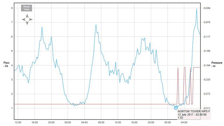
This reading shows the reduction in minimum nightline after the identified leak had been repaired
Once the image is received, it undergoes a three-step process before delivery to the client. The first step requires no field works and instead focuses on collecting data for actual locations on Earth to ensure accuracy.
In the second step, signals returns are filtered from common objects such as buildings, cars and vegetation that one can expect to find in dense and complicated urban environments. It is at this stage that utility pipe layers are applied as it is assumed that at this depth, treated water can only come from pipes, however, other possibilities are not discarded.
In the third step, algorithm analysis detects treated water by looking for a particular spectral signature that is common to drinking water. The user is then presented with a graphic report overlaid on a map with streets and pipes that show the areas of interest.
Previous testing has shown that varying water types might appear differently to the waves and made identifying the true signatures of treated water a crucial step. The technology now eliminates water sources such as oceans, rivers, water tables and sewage.
The end result is the simplest output imaginable – locations of potential leaks throughout the monitored area.
Locating leaks on the ground
Once the process is finished, the client will receive the data in the shape of a keyhole markup language (KML) format. This ensures the data can be added to their GIS systems, web or mobile applications, Excel and leak sheet and can then be used when carrying out field work.
The leaks are assigned according to the probability and are divided into a four-colour category: blue, green, yellow and red. Blue represents the lowest probability of a leak and red signifies the highest probability of a leak.
Yorkshire Water trials
In the UK, the technology is currently being trialled with Yorkshire Water as they explore ways to reduce leaks in their network. One set of results showed a 100 metre radius having five areas of interest that were identified as having potential leaks. Of the five areas, one resulted in a leak on an old clamp that was quickly located and repaired.
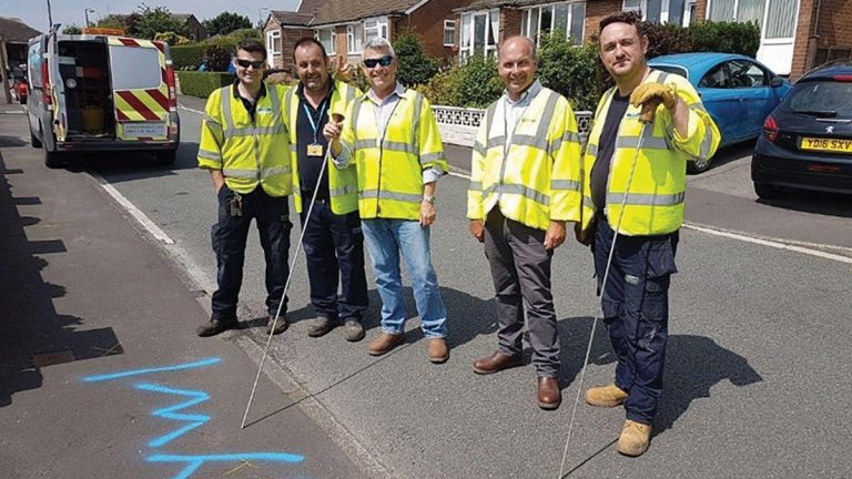
Experienced leakage inspectors stand by the located area marked for repair. Eddy Segal of Utilis (center left) and Nick Haskins of SUEZ Advanced Solutions (center right).
Benefits of satellite leak detection
Some benefits of the technology include:
- No preparations or upfront investments.
- Lower operational costs.
- Increased efficacy of field labour.
- Surveying of entire systems up to six times a year.
- Routing to leaks through geographic clusters.
- Priority leaks can be targeted quickly reducing potential damage and claims
Conclusion
Every water distribution system experiences leaks. The effort required to determine where the leaks originate from is greatly decreased with technologies like satellite leak detection which can help utilities to better manage their overall systems.
More information about SUEZ satellite water leak detection contact: SUEZ Group | +44 (0)1454 804040 | Website
![]()