
WAMM (Water & Abandoned Metal Mines) Programme (2019)
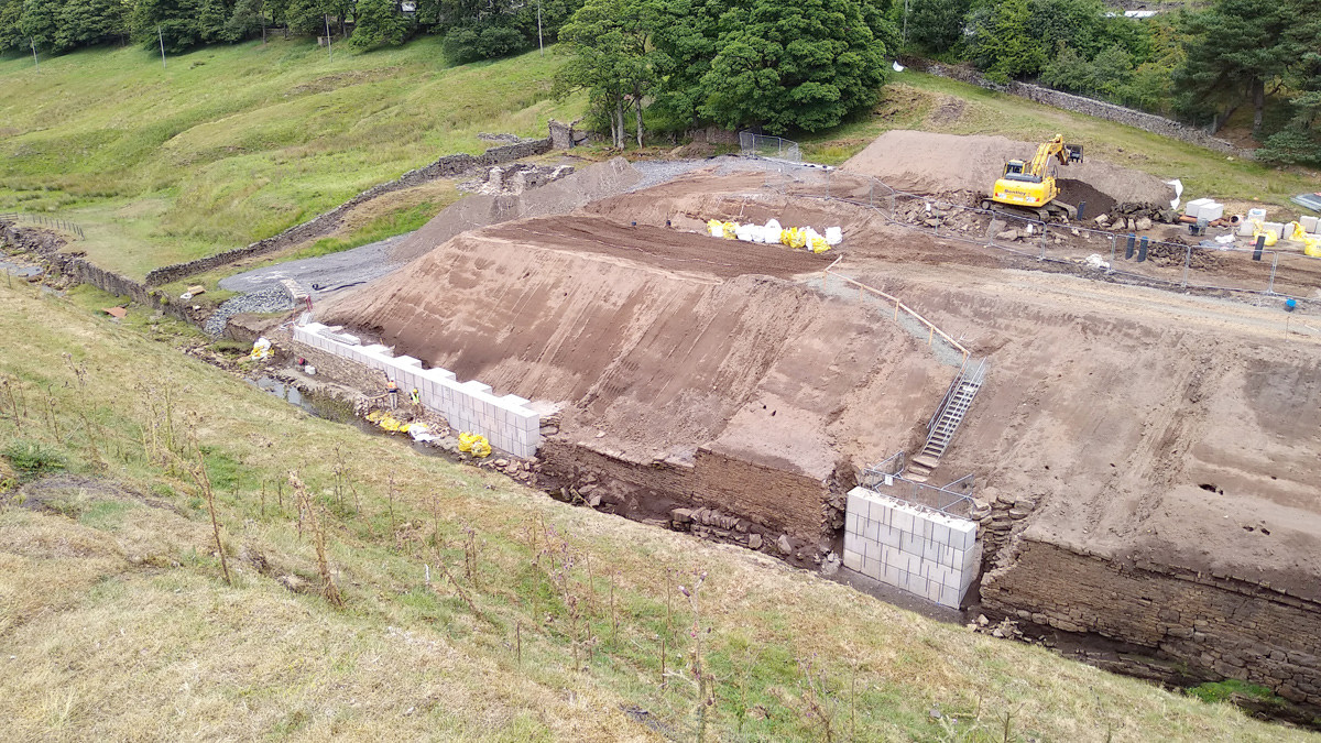
Carrshield Tailings Dam under construction August 2018 - Courtesy of Newcastle City Council
Abandoned metal mines pollute approximately 1,500km of rivers in England and contribute about 50% of the cadmium, lead and zinc in surface waters despite most closing in the early 20th century. The WAMM (Water and Abandoned Metal Mines) Programme is a partnership between the Environment Agency, the Coal Authority and the Department for Environment, Food and Rural Affairs (Defra). The Programme aims to support the Government’s 25 Year Environment Plan and River Basin Management Plans by implementing measures to address severe chronic river pollution and deliver a cleaner water environment for people and wildlife.
Introduction
Monitoring by the Environment Agency shows that historic mining wastes containing elevated concentrations of zinc, lead and cadmium make a significant contribution towards pollution of 100km of the Rivers Nent, West Allen and South Tyne. Ultimately these metals accumulate in the Tyne estuary sediments which has potential implications for dredging activities necessary to maintain deep water berths. Several interventions were constructed in 2018/19 to address metals pollution, funded by Defra and the North East Local Enterprise Partnership’s (NE LEP) Local Growth Fund.
JN Bentley under the Confluence Framework with The Coal Authority was employed to carry out a number of contracts around the Cumbria/Northumberland border.
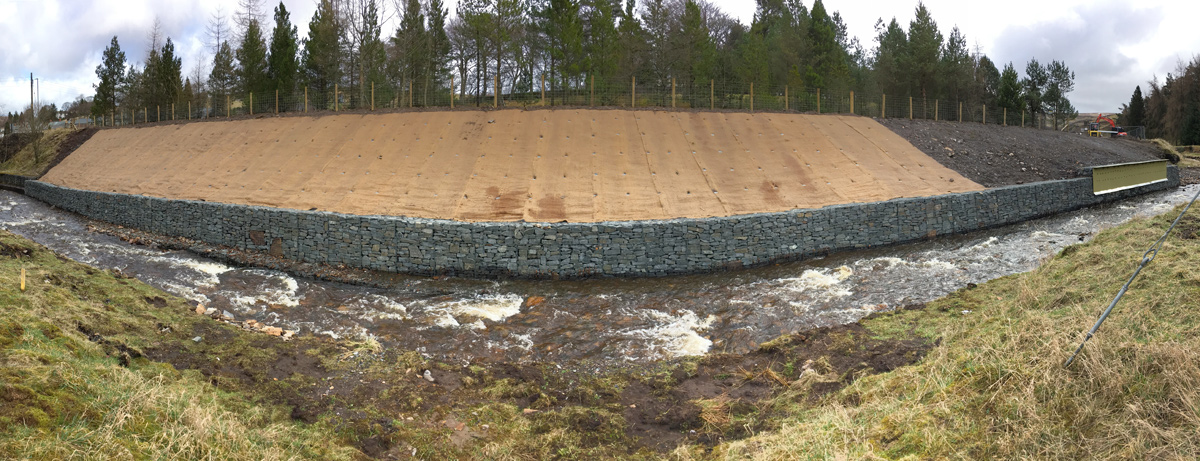
Carrshield: Tailings Dam
The Carrshield Tailings Dam stores about 48,000m3 of highly metal contaminated mine wastes behind a dry stone wall constructed in the 19th Century. Up to 3 tonnes of zinc, cadmium and lead is eroded each year from these wastes which contributes to pollution of 40km in the adjacent River West Allen, and into the Tyne estuary. The site is designated as a Scheduled Monument, is situated in the North Pennines Area of Outstanding Natural Beauty (AONB) in Northumberland and contains protected calaminarian grassland habitat. There was a high risk of catastrophic failure as the retaining wall was deteriorating.
In the initial stages an Atkins designed pilot trial was carried out assessing the feasibility of deep soil mixing to stabilise the wastes. The trial concluded that the proposed technique would not deliver the project objectives and there were numerous practical challenges. Further ground investigations and monitoring was undertaken and Golder Associates were commissioned to design the remediation scheme that would be sympathetic to the sensitive location and stabilise the wastes.
The primary cause of the failures of the retaining wall were identified as increases in pore water pressure within the tailings as a result of surface water recharge. The key remedial design principle was to prevent ingress of surface water to the wastes.
Carrshield Tailings Dam before construction (June 2018) – Courtesy of Environment Agency
Engineering works were implemented to reduce the loading on the retaining wall and minimise water flow through the tailings and retaining wall. The engineering works consisted of a surface water interception drain to the rear of the wastes, repairs to failed sections of the retaining wall, regrading and capping the tailings.
As well as the challenges posed by the site’s remoteness and variable weather conditions the site team were also faced with reconstructing a retaining wall from an elevation difference of 7 to 8m exacerbated with poor ground conditions.
The working surface of the tailings storage facility comprised of soft silt mine waste and provided low bearing capacity for plant requiring a 3m minimum exclusion zone from the exposed edge. It was understood that during the pilot trial, the ground had started to liquify caused by the vibrations of an idling excavator. Temporary works platforms and access tracks were designed and created on the tailings in order to use a 45t long reach excavator and a 50t crawler crane.
Removing all the material from behind the failed sections of walls to a safe angle of repose was not possible due the restricted working area on site so an engineering solution and methodology had been designed. The initial Mott MacDonald (MM) design prescribed the installation of a trench box to the toe of an excavated slope, steel piles installed at each open end of the box and then filling this with concrete to create a ‘buttress’. Further boxes would then be installed on a hit one, miss one basis at 1.5m spacings.
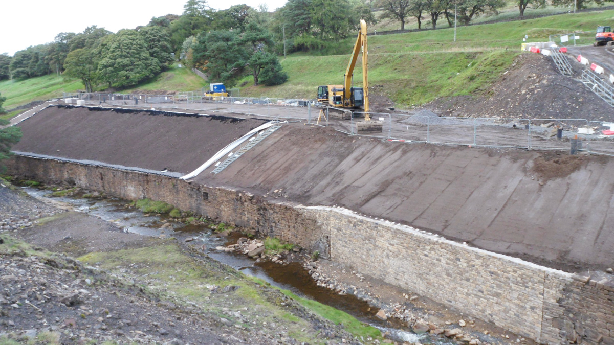
Carrshield Tailings Dam during construction (August 2018) – Courtesy of Newcastle City Council
On first excavation to the designed profile prior to box installation the existing material (described as ‘engineered backfill’ in the ground investigation) was exposed. Within this fill, large boulders/rock waste was uncovered. The site team concluded that the installation of a trench box was not possible in this material using the prescribed ‘dig and push’ method.
Working closely with the MM geotechnical engineer the JN Bentley site team proceeded with an alternative methodology battering the excavation in sections and construction of a legato block wall using the crane from a designed position of safety. The buttress was then excavated out from behind the new wall and installed as a mass fill concrete pour in an excavation rather than using a trench box. This solution ultimately saved £90,000 costs and 8 weeks on the programme.
To maintain the visual integrity of the Scheduled Monument within this remote upland rural setting, it was agreed that the legato block wall would be faced with local stone. This was completed by Lambeth Stonework, a local stone mason, to the satisfaction of all stakeholders. A key requirement from Historic England and other stakeholders was to ensure the final landform retained the “look” of a tailings facility. As a result, a layer of metal rich tailings was placed above the impermeable cap; the final stage of the restoration project will be to seed the surface with local wildflowers including calaminarian (metal tolerant) species to minimise erosion and promote local biodiversity.
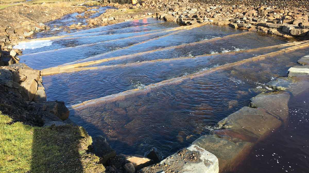
West Allen check weir and fish passage
The West Allen check weir site is located immediately downstream of the Carrshield tailings dam. The project aims to capture metal contaminated sediment already in the river alongside the interventions to limit future inputs. Previous investigations have shown that most of the metals are found in the silt to sand sized fraction. The project objective is to capture about 1 tonne of zinc, cadmium and lead is each year and so limit the movement of particulate metals down the River West Allen and into the Tyne estuary.
West Allen Checkweir location before start of work – Courtesy of JN Bentley
The design, by JBA, was to build a permanent structure across the river to encourage deposition and capture of metal-rich sediments under typical flow conditions. The weir needed to incorporate a fish pass to a design approved by the Environment Agency Fisheries Panel. A new access track would be formed to provide construction access and access for future dredging of the check weir.
In principle, the design consisted of a number of large rocks spanning and damming the river creating the 1m high check weir. Upstream of the check weir stone slabs were laid to the bed of the river to aid future dredging of contaminated sediments. Downstream, due to the height of the check weir and the gradient of the existing river a number of pre-barrages and rock pools were constructed such that fish passage could be maintained.
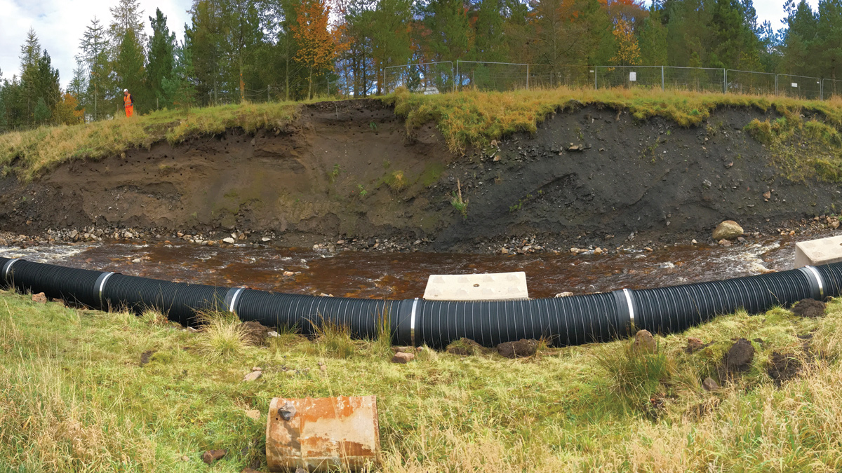
A permanent bypass pipe was constructed first allowing the construction team to work unhindered in the footprint of the existing river. This bypass will also be used during future dredging operations such that the river can be temporarily diverted and the deposition excavated without fear of creating silt in the watercourse.
In order to ensure the long term stability of the structure in the watercourse whilst maintaining an aesthetically pleasing finish the designer and contractor liaised closely with a local stone supplier to provide a cut finished article that could be mechanically lifted, seal and provide the requisite rock pools at low river flow and sustain the designed water loading.
West Allen check weir fish pass – Courtesy of Environment Agency
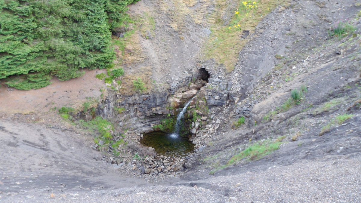
Garrigill
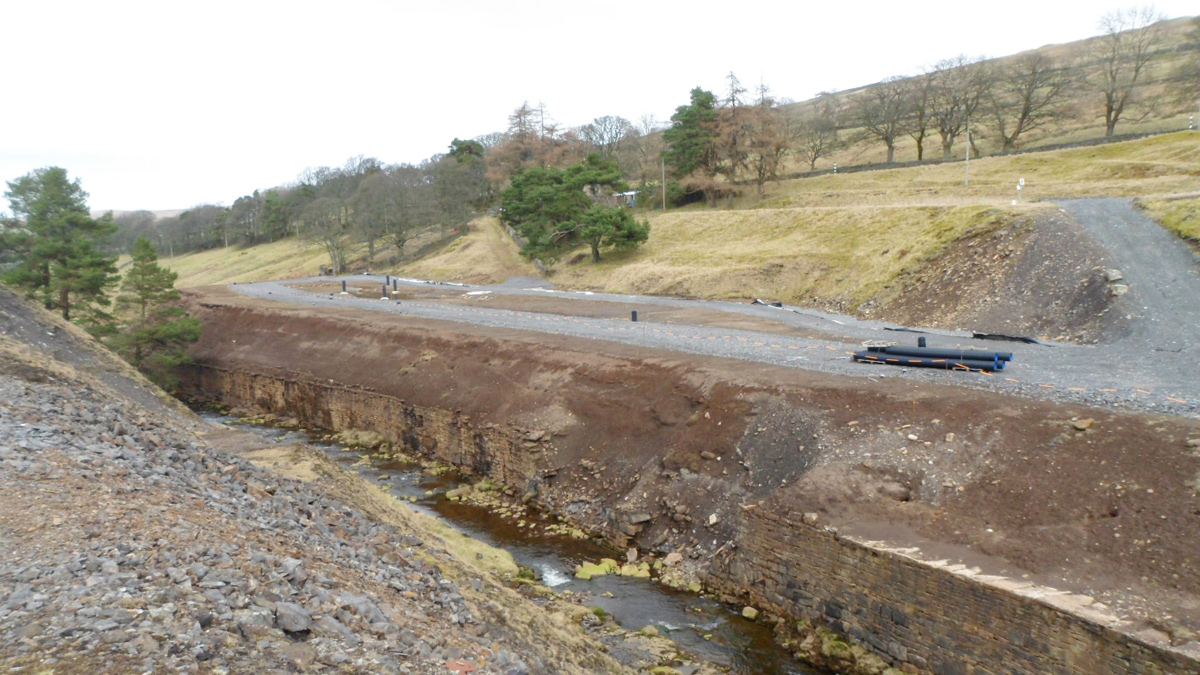
During the 19th Century mining operations, Garrigill Burn was partially culverted and covered with mine waste. The culvert had in part collapsed allowing an estimated 3 tonnes of zinc, lead and cadmium to enter the watercourse each year and pollute at least 10km of river. Around 60,000 tonnes of wastes remain on site, containing an estimated 1,400 tonnes of metals. The old mine site is designated as a Scheduled Monument, is located in the North Pennines AONB and contains priority calaminarian plants.
Thirteen options were initially considered by designers JBA, who, after considering all aspects of heritage, buildability and cost, recommended installing a solid piped connection between the upper and lower culvert, re-profiling the spoil heap and installing a new revetment at the downstream end to mitigate future slippage and run-off during high rainfall events. A detailed 3D survey of the existing culverts, the gap between them and the respective alignment between the culverts was used to determine exact pipe lengths and angles to ensure the pipes were installed right first time.
Garrigill aerial view before works – Courtesy of JN Bentley
The 22m height difference from the crest of the mine waste to the base of the lower culvert posed a significant challenge along with live connection of the new pipework to the culverts and managing the extremely flashy watercourse. Early contractor involvement had initially considered installing a rock armour revetment within the hole to take the water flow and at the same time support the new pipe. On reviewing the ground investigation results a suitable temporary works platform could not be constructed close enough to suit long reach excavator’s placing any material due to radius and capability and stability of the surrounding slopes.
Working with the designers, JBA, the methodology was changed to install the pipe using an 80t crawler crane, temporarily supporting and also strapping down the pipe whilst placing concrete surround to the pipe. Once the pipe was surrounded an access ramp could be formed into the void. Approximately 6,000m3 of the surrounding spoil slopes were benched and re-profiled over the new installed culvert.
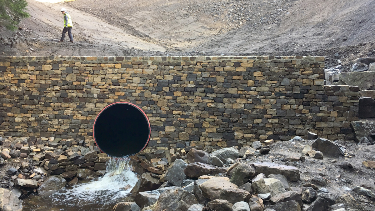
Headwall at outlet of new culvert – Courtesy of Environment Agency
A legato block wall was installed at the downstream end of the spoil heap and faced with natural stone (by the same local stone mason, Lambeth Stonework, who worked on the Carrshield project) to provide structural support and contain silts as a result of surface water run-off.
As part of the consent from the planning authority, patches of the calaminarian plant, thrift, were temporarily translocated to an adjacent field. On completion of re-profiling the wastes, these plants were placed back on the mine site under supervision by a specialist ecologist. The final stage of the restoration project will be to seed the surface with local wildflowers including calaminarian (metal tolerant) species to minimise erosion and promote local biodiversity.
Nenthead Carpark bank stabilisation
The bank of the River Nent by the Nenthead public carpark comprised largely highly metal contaminated mine spoil with some disturbed natural rock. Up to 1 tonne of zinc, lead and cadmium is being eroded each year with slope failure over a length of approximately 65m. The exposed embankment housed a population of sand martins and therefore the design and timing of construction of the scheme needed to address this.
During early contractor/designer liaison it was identified that the design was significantly dependent on the compaction properties of the existing material. WAC testing of the spoil deemed the existing material hazardous so it was imperative that the design allowed for flexibility and full reuse of the existing materials.
Nenthead car park river bank before construction – Courtesy of Environment Agency
A reinforced earth solution was modified following the ECI and the resultant design comprised of a gabion retaining feature, regrading the embankment to a more favourable angle and covering with an erosion protection layer anchored into the resultant slopes.
Due to the presence of two sets of overhead cables above the embankment the construction was carried out at low level from within the river bed. This involved managing the existing watercourse by temporarily damming and fluming the river to one side of the watercourse following a fish rescue exercise. The works were completed with the construction of an artificial sand martin habitat to a design approved by the RSPB.
Nenthead car park river bank completed – Courtesy of Environment Agency
Planning, archaeology and the environment
The site team also had to closely liaise with a number of stakeholders due to importance of these areas. Each site required planning permission before works started. Three of the above four sites had areas of archaeological importance requiring consultation and formal consent with Historic England, utilising a Written Scheme of Investigation and an archaeological watching brief during all excavation works.
Each site needed an Ordinary Watercourse Consent for working in or adjacent to the river and also interaction with the EA Fisheries team to support fish captures, rescues and surveys. Works at both Carrshield and Nenthead Car Park were required to work around the nesting bird season with the use of the steep slopes and walls for nest sites.
The abandoned mines also support small areas of calaminarian grassland, a plant community that includes species of vascular plants, bryophytes and lichens that are particularly associated with heavy metal mines. Many of these are obligate or facultative metallophytes, and some are nationally rare, nationally scarce, or are otherwise of conservation importance. The sites needed to work around these areas, transplanting those areas that could not be avoiding and working with the North Pennines AONB to agree the final landscaping and seeding arrangements at each site.
WAMM (Water & Abandoned Metal Mines) Programme: Supply chain – key participants
- Project managers & principal designer: The Coal Authority
- WAMM programme manager: Environment Agency
- Principal contractor: JN Bentley
- Design of Garrigill & West Allen check weir: JBA Consulting
- Design of Carrshield regrading and capping: Golders
- Design of Carrshield Tailings storage facility wall construction: Mott MacDonald
- Sponsors, support & funding: Defra & NE LEP
- Geosynthetic materials: ABG
- Legato blocks: Elite Precast
- Aquaspira pipework for Garrigill: Aquaspira
- Natural stone for West Allen check weir: Alston Natural Stone
- Dry stone walling at Carrshields & Garrigill: Lambeth Stonework
Conclusion
Delivering all these works in challenging areas with significant safety risks and through a whole variety of weather conditions JN Bentley is proud to report combined working of over 40,000 hours on these projects with an All Accident Frequency Rate of zero.
The diversity of engineering challenges on each of these projects has not only made these a demanding batch of works to design, gain numerous stakeholder permissions, and ultimately construct but also significantly satisfying when the efforts of detailed planning come to fruition.
These projects represent a substantial investment of Government funds to support delivery of the 25 Year Environment Plan and the Northumbria River Basin Plan, and therefore contribute towards a cleaner water environment for people and wildlife.