Foreness Point Intertidal Habitat Enhancement Plan (2017)
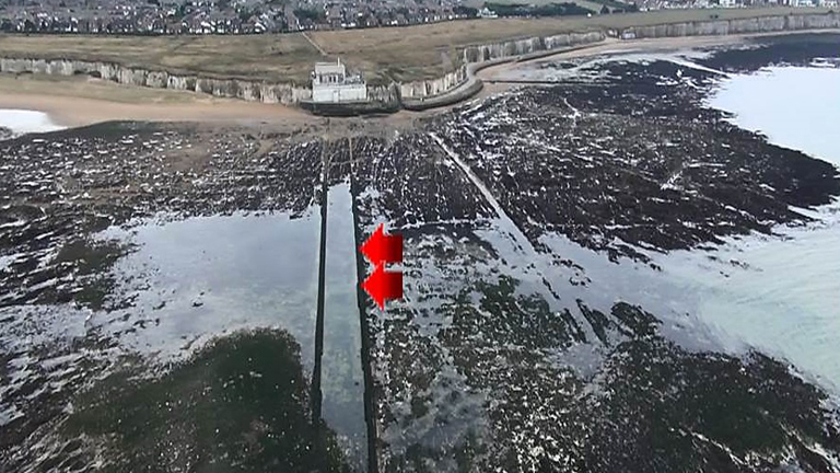
Margate WPS (background) with concrete groynes (centre and foreground). Courtesy of Mott MacDonald/Southern Water
In November 2016, Southern Water commissioned Mott MacDonald to conduct a study to examine the opportunities for devising possible habitat enhancement options via an Intertidal Habitat Enhancement Plan (IHEP). The aim of the study was to identify enhancement options that would be available to Southern Water to support coastal biodiversity in the intertidal zone adjacent to Margate Wastewater Pumping Station (WPS) on the Thanet Coast in Kent.
To inform the development of the IHEP, a review of existing enhancement studies and intertidal habitat surveys was carried out. A total of twelve marine habitats (known as biotopes) were recorded which reflected the underlying geomorphology and range of wave exposure conditions encountered across the survey site. Many biotopes were characterized by small areas of coarse sand and chalk reef habitat coupled with intermittent rockpools supporting low to moderate levels of algal and invertebrate species. Biotopes of conservation value (Sabellaria spp) were patchily distributed over 5 transect locations.
Taking these survey results and background data from previous scientific studies into consideration, this IHEP suggests five explorative options which could be investigated further and, if implemented, could enhance intertidal ecology at Foreness Point. Three of these concepts have been proven (rockpools, Bioblocks and bird nest provision) while two more (click and slide clam habitats and intertidal trees) will need to be tested & trialed to deliver proof of concept. The benefit in implementing these un-trialed techniques while analyzing and monitoring their success will potentially add to science, delivering additional benefits for site enhancements while based on scientific knowledge of sound evolutionary process that already exist in the marine environment (Mangroves and seaweed ecology and biology). The concrete walkways that extend out to the sea from the base of Margate WPS are a prime in situ habitat that should be utilized for enhancement and act as a saltwater reservoir, trapping water during low tides and supporting the various intertidal species present. The key to the IHEP design was to try to use existing habitat structures already in place to their full capacity. These suggested and some innovative options as part of this review are considered to have the potential to build in future resilience in this coastal zone while adding to science.
Introduction
The Environment Agency has undertaken enforcement actions against Southern Water in recent years relating to unauthorised storm releases from their outfall located at Foreness Point (Figure 1.1). A release occurred in June 2013. Hydrological modelling showed that the lifespan and distribution of the surface plumes from the June 2013 release moved parallel to the coast overall. However, during periods of onshore wind the plume was held more closely to the coast, whereas during offshore winds the plume tended to move offshore where it was dispersed.
Designated sites
Foreness Point is located within the Thanet Coast Biodiversity Opportunity Area (BOA), the target area of the Kent Biodiversity Action Plan (BAP). BOAs “indicate where the delivery of Kent BAP targets should be focused to secure the maximum biodiversity benefits and from habitat enhancement, restoration and recreation” (Kent Biodiversity Partnership, 2016). The Thanet Coast and Sandwich Bay Special Protection Area (SPA) Ramsar site, Special Area of Conservation, (SAC), Site of Special Scientific Interest (SSSI) and Marine Conservation Zone (MCZ) designations also include Foreness Point. The SPA site holds important numbers of Turnstone (Arenaria interpres) as qualifying features and is also used by large numbers of migratory waterbirds.
Section 40 of the Natural Environment and Rural Communities (NERC) Act 2006 requires public bodies, including utility companies, ‘to have regard to the conservation of biodiversity in England’ when carrying out their normal functions. The list of habitats and species of ‘principal importance for the conservation of biodiversity in England’ (Section 41) guides public bodies in implementing their duty. An overarching aim of this conceptual IHEP is to support further conservation of biodiversity and through these tested and untested but innovative enhancement options aiming to support further delivery of statutory requirements.
Current enhancement options & experiments
When reviewing and considering the incorporation of biological enhancement into artificial coastal defense structures, there are some factors which are uncontrollable and context dependent, whilst other are controllable through careful design and planning (Table 1.1).
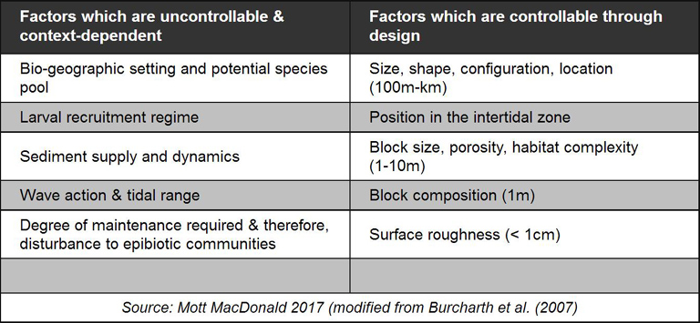
Table 1.1 Factors for artificial coastal defence structures design
Burcharth et al. (2007) illustrated the various measures that coastal managers can take at a range of spatial scales to increase biodiversity in artificial coastal habitats. Artificial coastal structures make poor surrogates for natural rocky shores, often supporting lower species diversity but supporting higher densities of opportunistic species such as ephemeral green algae and barnacles. Artificial, introduced or enhancement structures generally lack the environmental heterogeneity and surface roughness that is usually present on natural rocky shores, enabling them to support greater numbers of individuals and species.
The geology of the substratum can have a significant influence on the diversity and abundance of the colonizing community. In addition, micro-scale surface roughness (< 1 mm) can also have a very important impact on community structure. In general, smooth, artificial substrates support less diverse and abundant communities, whilst rougher natural substrates favour more diverse assemblages. The Universities of Exeter and Plymouth have experimented with the colonization and weathering of engineering materials by marine microorganisms with examples presented in this paper. Experiments were carried out comparing the micro-scale biological growth features of marine concrete, Cornish granite, and Portland limestone blocks. It was revealed that granite blocks supported the greatest micro-scale colonization in comparison to concrete and limestone blocks. Heterogeneity of the environment is essential for species co-existence, with structurally complex habitats offering a great variety of different microhabitats and niches, therefore allowing species to co-exist and is, therefore, an important mechanism in the maintenance of biological diversity. Environmental heterogeneity can operate on a range of spatial scales: surface roughness on microscales (< 1 cm); surface heterogeneity such as pits and depressions on small scales (< 5 cm); and refuges, crevices, and rock pools on medium scales (< 5 m). Small scale pits (< 5 cm): Small littorinids (Littorina saxatilis and Melaraphe neritoides) commonly occupy small cavities or pits and empty barnacle tests or shells. Note in this experiment the winkles only occupied the pits and not the surrounding emergent rock.
Existing Options for Engineered Artificial Habitats
Diamond drill-cored rock pools: Exploration diamond drilling is used in the mining industry to probe the contents of known ore deposits and potential sites and this technique could be used to create artificial rock pools. In recent experiments using this technology in collaboration with Gwynedd Council and SMS Wales, Bangor University explored the opportunity of habitat enhancement by the incorporation of rock pools. onto the horizontal surfaces of some of the boulders. A total of 18 pools with two different depths (5 cm and 15 cm) were drilled in October 2011. It is expected that long-term monitoring over the coming years will reveal that diversity of flora and fauna will be higher in the pool habitats than on the surrounding rock. Furthermore, it is expected that diversity will be higher in the deeper pools than in the shallow pools. From the current IHEP perspective, this type of approach could be very useful with the extended parallel concrete or chalk structures that are already present on the beach with the potential to create up to hundreds of mini rock pools of different depths. The big advantage here is that the concrete structure is already in place (Figure 1.1) and can be modified in situ to create more habitats for intertidal species. Illustrations of this concrete or possible chalk structure is given in Figures 1.2 & 1.3. Further work would need to be done to establish the appropriate depths and cost effectiveness of this approach to maintain structural integrity of the concrete structures in place and balance this with ecological gain but this already in situ surface area offers substantial ecological advantages.
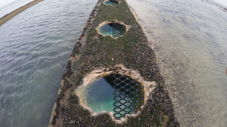
Artificial rock pools placed on top or sides of concrete groynes – Courtesy of Mott MacDonald/Southern Water
Drilled pits on artificial blocks: The artificial creation of small pits and depressions is a very cheap and effective way of increasing surface heterogeneity of small spatial scales (< 5 cm). These would be more complex in nature when compared to “normal” rock pools. Again, in recent experiments prior to positioning on the Plymouth Breakwater, drilling pits of varying diameter, depth and spacing distance was used to modify the large concrete blocks. Such a large number of pits (2.5 cm) requires a drill that is either driven by petrol or a generator. These pits provide unique habitat for a range of different marine and coastal floral and faunal species. Over time these pits became colonised by species that would be otherwise unable to inhabit the smooth surface of the concrete block, such as red algae and blue rayed limpets. Similar approaches could be used in this current IHEP due to the large surface area of the parallel concrete structures found in front of the WPS.
Drilled pits on panels on coastal breakwaters: A further example was presented at a site in Elmer, West Sussex; which provided one alternative method incorporating the addition of pits to artificial structures comprising affixing tiles with pre-drilled holes. This method meant that habitat enhancements could be carried out using a cordless, battery-driven drill rather than a power-driven drill. This method would enable enhancements at locations that are difficult to access or do not have a power source including existing structures within low tidal areas at Foreness Point.
Bioblocks: While further reviewing current examples of Projects that have focused on coastal enhancement in 2011 Conwy Council in collaboration with the SEACAMS partnership and Ruthin Precast Concrete (RPC), Bangor University developed a large-scale habitat- enhancement unit called the ‘Bioblock’ The Bioblock was designed to be incorporated into rock armour breakwaters, groynes and revetments at the construction stage. The objective of the Bioblock was to provide additional habitat types that would not be present on the rock armour structure. The precast Bioblock measured 1.5m x 1.5m x 1.1m, weighs approximately six tonnes and has been designed in such a way that it has multiple habitat-types on the different faces of the block:
- Rock pools of different depths and diameters on the horizontal surface.
- Circular pits of different depths on the vertical sides.
- Longitudinal depressions also on the vertical sides.
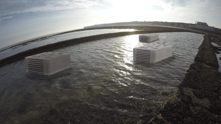
Bioblocks in main water channel – Courtesy of Mott MacDonald/Southern Water
This type of technology can be incorporated into the IHEP for Foreness Point, being adapted to suit local intertidal environment, and further adapted so that species responses are enhanced with key habitat complexity. Consideration should be given to large/medium sized chalk no concrete blocks (being easily sourced) which would naturalise rapidly and have potential for boring intertidal species and could even be pre-drilled to some extent. This kind of habitat is scarce on local reefs because sea defenses have prevented the natural cliff fall that replenished the chalk/flint boulders of the intertidal. Chalk does come in various degrees of hardness and if the tougher chalk is used it would have a considerable life span in a sheltered environment between the coastal outfalls or discharge points.
Bird habitat enhancements nest site provision: Many species of bird will use artificial nest sites where these are provided. Most of the focus on nest provision and use has been by small songbirds (passerines) although owls, ducks, geese and some seabirds are also known to use artificial nests (De Feu, 2003). The uptake rate of artificial nest sites is likely to vary between species and between sites. Those sites where natural nest sites are limited are likely to have higher uptake rates than those where natural sites are not limited. A review of 209 artificial nest studies showed that in 61 cases, productivity was similar or higher than natural nests (Williams et al, 2012).
Three species recorded on site are likely to take to artificial sites. Sand martin (Riparia riparia) are known to breed in the cliffs along the Thanet Coast (Canterbury City Council, 2015). Rock pipit (Anthus petrosus) were present on site and are known to nest in rock crevices, including those in rock gabions. Lastly, fulmar (Fulmarus glacialis) are known to breed in small numbers on the cliffs along the Kent and Thanet coast (Canterbury City Council, 2015; Kent Biodiversity Partnership, 2017). Four fulmar were recorded on the cliffs 100m west of the WPS and whilst their occupation of the cliff was indicative that the site is suitable for breeding, breeding evidence is not known from this site. Fulmarine petrels, including Southern Fulmar (F. glacialoides) are known to breed on artificial nests where these have been provided to support scientific research (Creuwels et al, 2000).
High tide roost site enhancement: High tide roosts are characterised by unrestricted views over at least 200m to allow for early detection of predators. High tide roosts are present above mean high water around Foreness Point including turnstone (Arenaria interpres) which are known to use the WPS platform. Signage on the site indicates that roost sites are subjected to disturbance pressure. Cormorants (Phalacrocorax carbo) and gulls were observed roosting on the inaccessible short sea outfall but the structure appeared suboptimal in terms of shelter and space.
IHEP enhancement options for Foreness Point Margate
Bioblocks or equivalent structures: Use of Bioblock intertidal targeting coastal crustacean and fish species would be further complimented by engagement of local stakeholders using social media. Bioblock equivalents could be made from local chalk to keep consistency of the habitats already there as opposed to concrete.
Purpose drilled artificial rockpools: Recommendations include purpose drilled artificial rockpool pits at various depths on concrete walkways or at the sides of the walkway continuing out to sea being created. Up to 100 of these pits are recommended could to be created with a variation in depth along the defined intertidal zones, 50 could be positioned on each side, each tailored to the intertidal zone they fall within. The key element here would be to make sure all rock pools are of different depths and diameters on the horizontal surface and can be placed on the top of the pathways or into the sides of the pathways to create crevices for intertidal species. Having rock pools on the sides of these structures and on the vertical faces would create some diverse caves for the cyptofauna, (fauna that exists in protected or concealed microhabitats) which is lacking in this area (EA pers comms).
Slide and click clam habitat (to be trialed): Along the inside walls of the concrete pathways, specially made slide and click “clam/cockle habitats” will be created. This slide and click mechanism and specifically the cockle shell shape habitat design will be based on millions of years of evolution which over this timescale has created habitat for small intertidal species providing them refuge. They will be made of ecogreen concrete or local chalk material being precast and positioned in place along the rails. The clam structures should be made from a concrete mould with the pH of the concrete being nearer to sea water pH, to encourage rapid colonisation but use of chalk as a substrate should be explored given its local availability. They will deliberately vary in size and quantities purposely to target intertidal species of various sizes and be placed in parallel lines on a slide mechanism having been already preloaded on rails with clam or clam shells of various sizes. There can be 10 to 15 of these structures on one rail then fitted to the concrete walkways and hundreds of these can be added with small variation in heights to mimic variations in waterlines with changing tides. When adhered to the concrete walkways they will create a unique sculpture and habitat for different life stages of crustaceans and intertidal species. This type of clam habitat will provide refuge for developing crabs and fish fry refuge as well. Examples of marine creatures utilizing cockle and clam shells are presented in figures presented below.
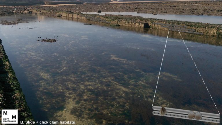
Slide and click clam habitats (Slide mechanisms allow ease of installation) – Courtesy of Mott MacDonald/Southern Water
Artificial intertidal trees (AIT) (to be trialed): AIT (manufactured with recycled / sustainable materials) could be placed in each drilled rock pool along the concrete pathways. AIT is a new innovative approach based on millions of years of seaweed and mangrove evolution. This concept will focus on developing AIT which will be placed in the centre of each newly drilled rock pool or inside the main concrete pathway channels possibly between the bioblocks natural architecture of a kelp forest underwater ecosystem. Its design will be based on the kelp’s physical structure, and how it influences the associated species that define its community arrangement while supporting coastal biodiversity providing habitat, food, and shelter for coastal organisms. Kelp species are recognized as one of the most productive and dynamic ecosystems on Earth and using the natural evolutionary research and development built up over millions of years will help to support enhancement opportunities at Foreness point.
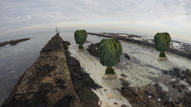
While an unproven concept these are examples of artificial intertidal trees – Courtesy of Mott MacDonald/Southern Water
Bird habitat enhancements
Nest site provision: Considering the proximity of Margate WPS to potentially suitable fulmar breeding habitat, it is proposed to place four artificial nests on the WPS frontage no closer than two metres apart. The nests will be located on top of the horizontal geison (i.e. the edge below to top of the frontage). The nests will be shallow boxes (78 cm x 40 cm x 30 cm) constructed of metal or plastic suitable for long-term use in a marine environment. The interior space of the box will be filled with stone chips. The location of the boxes on the WPS frontage will allow CCTV to be positioned above the nests to allow them to be viewed for the purposes of scientific education on site with the potential for the video to be streamed on the internet for external education use and public relations profile raising.
It is also proposed that holes are drilled through the WPS architrave (the lowest part of an entablature that bears on the columns) and tunnels and sand martin nesting chambers installed on the interior side. Precast tunnels and chambers are available (http://www.schwegler-natur.de) but these will need to be modified by being mounted on a shelf and to ensure that the distance from the entrance hole to the chamber is no more than 100cm. The entrance holes in the architrave will be 5cm in diameter in a checkerboard pattern at 800mm horizontal spacing and 450mm vertical spacing. Rock gabions baskets should also be installed at the base of the cliff on the platform between the eastern and western corners of the WPS frontage and the security fence. The stone fill should be angular and as large a size as available (up to 200mm). The baskets will provide additional breeding opportunities for rock pipit.
High tide roost site enhancement: The platform in front of Margate WPS is known to be used by wading birds as a high tide roost. Small numbers of turnstone were noted using the platform during the site visit. High tide roosts are most suitable when such sites have wide, uninterrupted views. It is proposed to reduce the viewing obstacle by reducing the angle of the security fencing to 45° or less. The current security fence is vertical with a gap separating the lower part of the fence from the concrete platform. This allows small birds to land on the lip of the concrete platform and walk under the fence to access the platform. A new fence with a shallower angle attached to the lip of the platform will reduce the enclosed nature of the platform and enable better access to the platform for larger birds. By improving this platform, whilst still maintaining its security, the importance of the platform to roosting wading birds at high tide should increase. Reducing the profile of the security fence will consequently increase the visibility of the WPS frontage. To reduce the visibility of the frontage, compared to the surrounding nature cliffs, it is proposed that repainting of the frontage using digital camouflage (a computer-generated digital pattern using fractals) or other painting technique will be used. Additional roosting potential can be created by providing a platform on the short sea outfall. A wooden floor spanning the upper cross members of the structure will provide a great surface area for roosting birds to utilise. The floor would be similar to that found on wooden quay structures and would allow for water to freely drain. CCTV could also be installed and used for educational purpose and/or streamed to the internet for the purposes of public engagement.
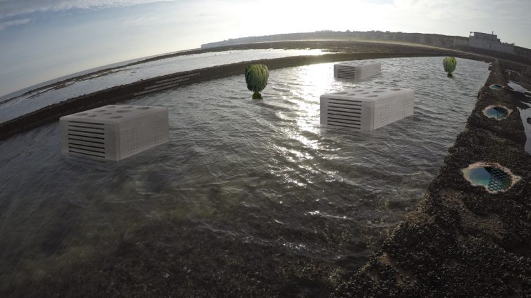
Combined intertidal enhancement visualizations – Courtesy of Mott MacDonald/Southern Water
Conclusions
The current version of the IHEP for the intertidal zone adjacent to Margate WPS aims to take a comprehensive approach in implementing a tailor-made plan to achieve its objectives. It will make use of best practice and enhancement options available and look to tailor these to the Foreness shore intertidal area. Once these options and operations have been implemented, a monitoring programme could be put in place to verify the effectiveness of these options. It is expected that long-term monitoring over the coming months to years will reveal increased diversity of flora and fauna in the surrounding rock pool habitats and surrounding rock structures. This monitoring programme could also involve local stakeholders and look to further evolve into full integrated stakeholder engagement activities. The enhancement principles presented above are the basis for an adaptive management plan of the site.
Taking all this research into consideration including the proven and untested options several actions have been identified that could enhance the foreshore area at Foreness Point. The first step in the enhancement plan should consist of further ecology surveys to clearly establish the baseline especially in the concrete water channel so that correct site selection is pinpointed to place new intertidal structures. Preliminary results from intertidal surveys do show good site fidelity and selection. Taking existing survey results and background data into consideration, this intertidal enhancement plan details several options which should be investigated further and where possible implemented to boost and support intertidal ecology at Foreness Point.
References
- Canterbury City Council, (2015). Reculver Country Park Management Plan 2015 to 2020. [pdf] Available at: www.canterbury.gov.uk [Accessed on 13 March 2017].
- Coombes M.A., Naylor, L.A., Thompson, R.C., Roast, S.D., Gómez-Pujol, L. & Fairhurst, R.J., (2011). Colonization and weathering of engineering materials by marine microorganisms: an SEM study. Earth Surface Processes and Landforms 36: 582-593.
- Creuwels, J.C.S., van der Veer, W. & van Franeker, J.A., (2000). AWIN, an automatic weigh and identification nest-system to study petrels in Antarctica. [online] Available at: http://www.noldus.com/events/mb2000/program/abstracts/creuwels.html [Accessed on 13 March 2017].
- Du Feu, C., (2003). The BTO Nestbox Guide (BTO Guides). BTO, Thetford.
- Evans A,H, Louise B. Firth B,C,D, Stephen J. Hawkins C,E, Elisabeth S. Morris F, Harry Goudge F and Pippa J. Moore A,G (2014). Drill-cored rock pools: an effective method of ecological enhancement on artificial structures Marine and Freshwater Research http://dx.doi.org/10.1071/MF14244
- Firth, R.C. Thompson b, K. Bohn , M. Abbiati d, L. Airoldi ,h, T.J. Bouma e, F. Bozzeda , V.U. Ceccherelli , M.A. Colangelo d, A. Evans, F. Ferrario d, M.E. Hanley f, H. Hinz, S.P.G. Hoggart , J.E. Jackson b, P. Moore E.H. Morgan a,†, S. Perkol-Finkel, M.W. Skov a, E.M. Strain d, J. van Belzen e, S.J. Hawkins (2013) Between a rock and a hard place: Environmental and engineering considerations when designing coastal defence structures. Coastal Engineering 87 (2014) 122–135
- Firth, R.C. knights A.M, Bridger, D, Evans, A.J Mieszkowska, N Moore, P.J. O’connor ,N sheehan, E.V. Thompson R.C & Hawkins S.J (2016) Ocean sprawl: challenges and opportunities for biodiversity management in a changing world. Oceanography and Marine Biology: An Annual Review, 2016, 54, 193-269
- Kent Biodiversity Partnership, (2016). How should Biodiversity Opportunity Area maps and statements be used? [online] Available at: http://www.kentbap.org.uk/images/uploads/how_should_BOA_statements_be_used_-_RM.pdf [Accessed on 15 November 2016].
- Kent Biodiversity Partnership, (2017). Maritime Cliffs & Slope – Kent BAP | Habitats and Species. [online] Available at: http://www.kentbap.org.uk/habitats-and-species/priority-habitat/maritime-cliff-and-slope/ [Accessed on 13 March 2017].
- Magic, (2016). Multi-Agency Geographic Information for the Countryside, [online] Available at: http://www.magic.gov.uk/home.htm [Accessed on 15 January 2017].
- Moschella, P.S., Abbiati, M., Åberg, P., Airoldi, L., Anderson, J.M., Bacchiocchi, F., Bulleri, F., Dinesen, G.E., Frost, M., Gacia, E., Granhag, L., Jonsson, P.R., Satta, M.P., Sundelöf, A., Thompson, R.C. & Hawkins, S.J., (2005). Low-crested coastal defence structures as artificial habitats for marine life: Using ecological criteria in design. Coastal Engineering 52: 1053- 1071.
- Mott MacDonald, (2014). Swalecliffe Pollution Incident – Water Quality Modelling Technical Report for Southern Water.
- Mott MacDonald, (2016). Margate Pollution Incident – Water Quality Modelling, Mott MacDonald 2016).
- Williams, D.R., Pople, R.G., Showler, D.A., Dicks, L.V., Child, M.F., zu Ermgassen, E.K.H.J. & Sutherland, W.J., (2012). Bird Conservation: Global evidence for the effects of interventions. Pelagic Publishing, Exeter.
- Witt, J *, Sheehan E.V ,Bearhop ,S, Broderick AC, Conley ,D.C, Cotterel S P, Crow E , Grecian W.J , Halsband ,Hodgson D.J, Hosegood P , Inger M , P.I, Sims, D.W , Thompson , Vanstaen ,K, Votier S.C , Attrill M J and Godley B J. (2012) Assessing wave energy effects on biodiversity: the Wave Hub experience. Phil. Trans. R. Soc. A (2012) 370, 502–529 doi:10.1098/rsta.2011.0265.


