Countess Wear STW (2016)
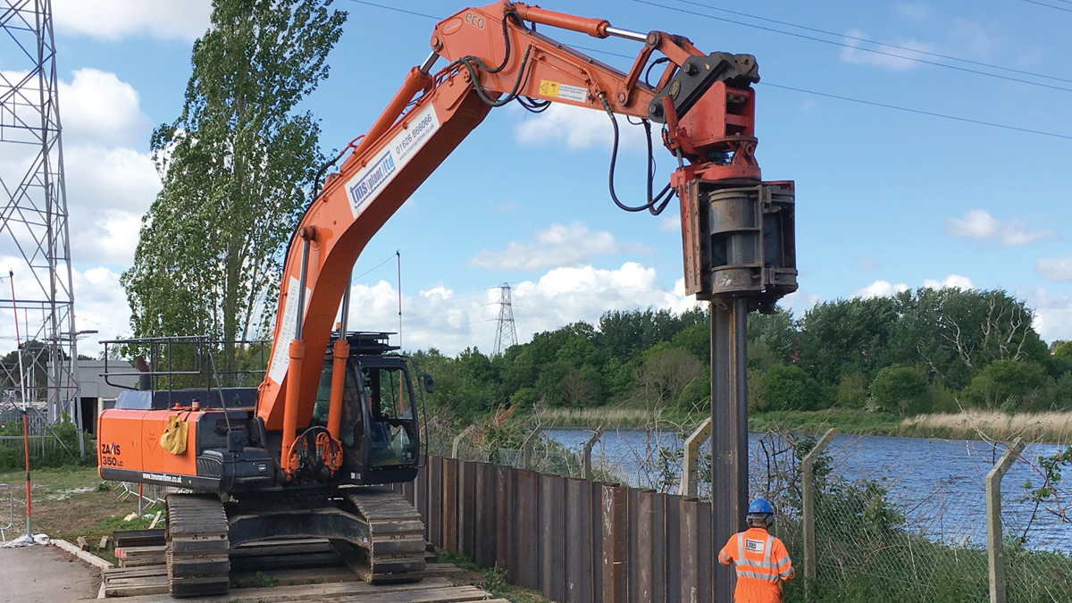
Excavator fitted with Movax attachment - Courtesy of SWW Delivery Alliance H5O
Countess Wear STW is located to the south east of the city of Exeter in Devon. Located on the edge of a large residential area, the works is bounded by the River Exe to the east and the Exeter Ship Canal to the west. Countess Wear is best known for the locations of the Countess Wear Bridges, which are a group of three bridges across both the River Exe and the Exeter Canal. Before the M5 motorway bypass this was the main route from the rest of England to the popular holiday resorts of Devon and Cornwall.
Background
Countess Wear STW was constructed on marshland of the River Exe estuary floodplain. Development of the works over time has led to the ground across most of the site having been raised by filling, in particular the northern and eastern frontage. The ground levels are generally higher on the sewage treatment works perimeters. There is a need to implement flood protection measures to protect the works from the significant effects of an extreme flood event.
The project objective included the need to maintain serviceability under flood conditions or provide the ability to recover serviceability within two days of flood waters receding. Maintenance of serviceability in this instance included process compliance, prevention of pollution and provision of sewage disposal capability. The existing assets needed to be protected, including key control equipment, but also extensive laboratory equipment, as these provide the main laboratory services for South West Water.
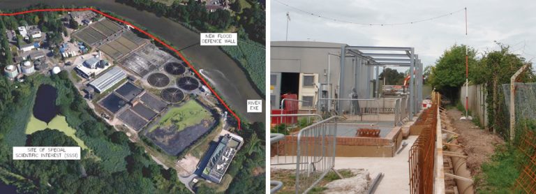
(left) Proposed output delivery option and (right) Reinforced concrete wall construction – Courtesy of SWW Delivery Alliance H5O
Protection
Due to the nature of the ground conditions there is a risk that the site will flood through one of two potential methods. These are i) overtopping, based on limited duration of breach of defences, and ii) excessive ground water levels caused by hydraulic head of external water levels, under both fluvial and tidal conditions. This risk will progressively increase with time due to the influence of climate change. Under flood conditions there is an additional risk associated with spillage of sewage coming in to the works, as the gross overflow channel in the inlet works has the potential to flood the site when the outfall becomes tide locked.
The Environment Agency proposed an appropriate level of flood protection at 4.95mAOD, which was based on the highest predicted water level for the tidal 200 year event plus climate change for the 2115 scenario (in excess of 1m), combined with the fluvial 2 year event plus 20% climate change for the 2115 scenario.
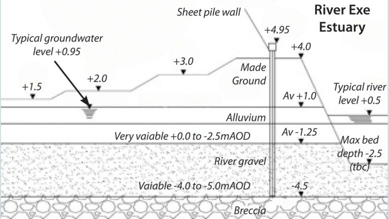
STW operational area – Variable surface elevation. Typical sheet pile cross section – Courtesy of SWW Delivery Alliance H5O
Summary of options
A significant number of options were considered for this project and included both partial protection and full protection of the site. There was also the opportunity to phase the improvements.
The partial protection options provided protection of the key M&E infrastructure and for some smaller sections of the site. These options were still an expensive and the risk remained regarding a large pollution incident that would be caused by sections of the site being inundated with water and the associated clean-up operation required on the site. For these reasons partial protection options were discounted.
Options for protection of the whole STW were looked at with varying depth sheet piling and groundwater control measures required. This also included a consideration of the ability to implement the solutions in a phased manner.
Ground conditions
To supplement the existing data, a project specific ground investigation survey was undertaken to improve the characterisation of the ground conditions around the site perimeter and to provide hydrogeological data. Monitoring wells were installed to record the tidally influenced groundwater pattern.
The ground was found to be relatively uniform with four primary layers of material. The makeup of the ground was generally:
- Made Ground (original marsh level) +1.0m AOD.
- Alluvium with variable base elevation between O.D. and -2.5mAOD.
- River gravel with medium dense grey-brown sand and gravel, present down to -4.5mAOD.
- Permian Breccia (bedrock).
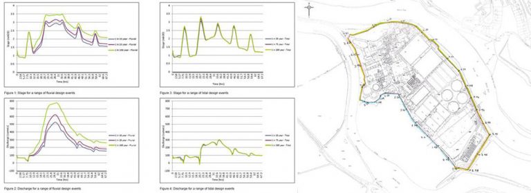
Hydrogeological Characterisation Investigation Data – Courtesy of SWW Delivery Alliance H5O
The groundwater flooding risk arises primarily from the presence of permeable river gravel. To allow this to be rationalised a computational hydrogeological model was constructed and an exercise undertaken in order to inform and optimise the extent and depth of sheet piling that would be required under differing fluvial and tidal scenarios.
Options for protection of the whole STW were looked at with varying depth sheet piling and ground water control measures required. This also included a consideration of the ability to implement the solutions in a phased manner.
Preferred option
The tidal flood levels were considered to be the predominant source of flood risk from overtopping. Provision of defences to a lower level than the suggested 4.95mAOD on to the River Exe would not be supported by the Environment Agency, as it would be considered too short-term in the area of highest overtopping risk.
However, a risk-based approach was proposed to the Environment Agency based on 35-40 years climate change allowance on the south-western perimeter, where the canal afforded protection to a level of 4.1mAOD.
Utilisation of the canal to provide protection to the western side of the works, removes the need for construction of a 3m high defence at this time and potentially more detrimental to the adjacent SSSI. This facilitated the phasing of the work and should climate change not occur as predicted, or other regional defences are enhanced, it may be that the need for future investment is further delayed or even obviated.
The sheet pile defence onto the River Exe was determined to be approximately 8m deep (10m total, onto bedrock) in the area of prime risk of groundwater ingress, with reduced sheet piles (5m deep) and/or concrete wall on the remainder of the boundary. This was established as a cost effective solution utilising the results from the hydrogeological groundwater modelling.
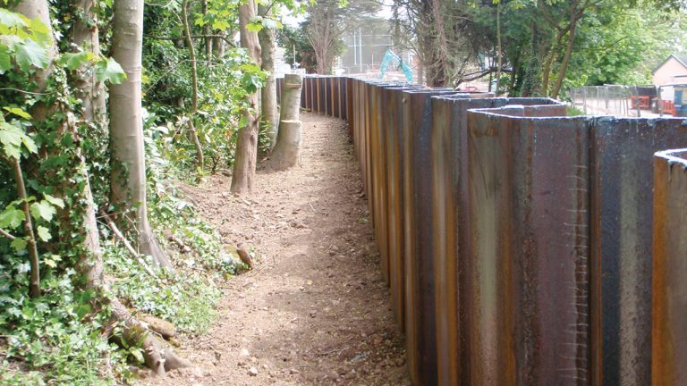
De-vegetation to accommodate sheet piling – Courtesy of SWW Delivery Alliance H5O
The following is a summary of the scope of works:
- 397m of 10m sheet piling.
- 112m of 5m sheet piling.
- 95m of reinforced concrete wall.
- Pipework modifications.
An operational flow control philosophy is to be implemented which maintains treatment for as long as possible to prevent flooding of the works from the gross outfall and to provide rapid return to full operation following a significant event.
Consultation and environmental
The Exe estuary can be characterised as a mosaic of coastal habitats that supports internationally important over-wintering and passage water birds. It is an internationally designated Ramsar site, a Site of Special Scientific Interest and a Special Protection Area. It is also home to the UK’s largest flocks of avocets, a number of rare plants and invertebrates, and a rediscovered species of fly recently believed to be extinct.
Following consultation with Devon County Council a screening opinion decision was obtained confirming the work was permitted development and that an Environmental Impact Assessment (EIA) was not required. It was necessary to embrace the constraints that Natural England had in relation to the methodology and timing of the works. Only non-intrusive works were allowed during the winter period, particularly in order to minimise the effects on over-wintering birds.
Management and maintenance of the canal is the responsibility of Exeter City Council (ECC), who were consulted regarding the existing condition of this section of canal bank. The canal is an old structure which will not have been designed to current standards and factors of safety. However an indicative stability analysis was undertaken to validate the design assumptions. In view of the proposed risk-based approach, ongoing liaison with ECC is required regarding the condition, modifications and stability of the canal bank, together with a medium-term review of changes to water levels in both the canal and the river.
A prioritised, phased approach therefore resulted from the consultation with the Environment Agency regarding the appropriate level of protection required.
Construction
SWW’s Delivery Alliance – H5O, was responsible for delivery of this project with a team consisting of SWW as the client, Balfour Beatty as principal contractor and Pell Frischmann as lead designer. The designers had assembled all known site services information on to the construction drawings. However, this was not to be assumed as ‘accurate’ and Balfour Beatty (the delivery team) had to re-confirm by utilising ground-penetrating radar (GPR). This method is a geophysical method that uses radar pulses to image the subsurface. This is a nondestructive method and uses electromagnetic radiation in the microwave band (UHF/VHF frequencies) of the radio spectrum, and detects the reflected signals from subsurface structures. This would give the site team a more accurate assessment and also allow some mitigation of risk.
On completion of the surveys trial hole excavation commenced to establish the accuracy of the data. Over a period of 3 months approximately 175 trial holes were excavated using vacuum excavation supported by operatives (using air picks), to confirm the position of services and to investigate any anomalies that were discovered as an result of the excavations. Where bundles of cables were found a large number of trial holes were excavated to ensure the site team fully understood the route of each individual cable within the bundle. Ten services were either isolated or diverted, therefore minimising the total number of service crossing points to 21.
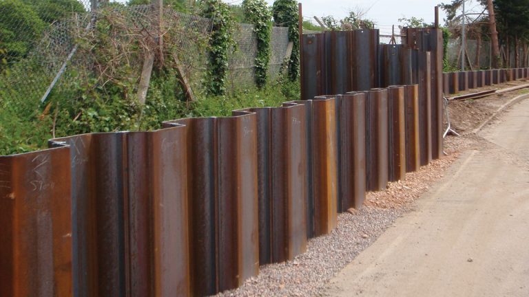
Sheet pile run in line with the perimeter fence – Courtesy of SWW Delivery Alliance H5O
When the site team had confirmed all services were located, the pile line was set out with 1.0m exclusion zones established around all services. Proof digging to a depth of 2.0m had been carried out, on what was believed to be unbroken ground, to identify any obstructions that could affect the piling programme. Excavation was carried out in 100mm layers under the supervision of a banksman, checking for changes in material, visible trenchlines and scanning for signals on the cable locator to further reduce the risk of damaging unknown services that had not been previously located.
A 35t ZX350LC-5 excavator fitted with a SP80 Movax attachment pitched and installed both the 10m and 5m piles, with a 700N air hammer to drive the piles to refusal where necessary. Services were isolated when piling within the exclusion areas to the services.
Conclusion
The construction works have been challenging for all concerned, involved painstaking avoidance of existing services and ensuring mitigation measures have been implemented to minimise the impact and better protect this highly sensitive environmental site.
Works are now approaching completion which means the site can maintain treatment and is better protected during extreme events caused by changing weather patterns and climate change.


