Kelham Road (Newark) Flood Alleviation Scheme (2016)
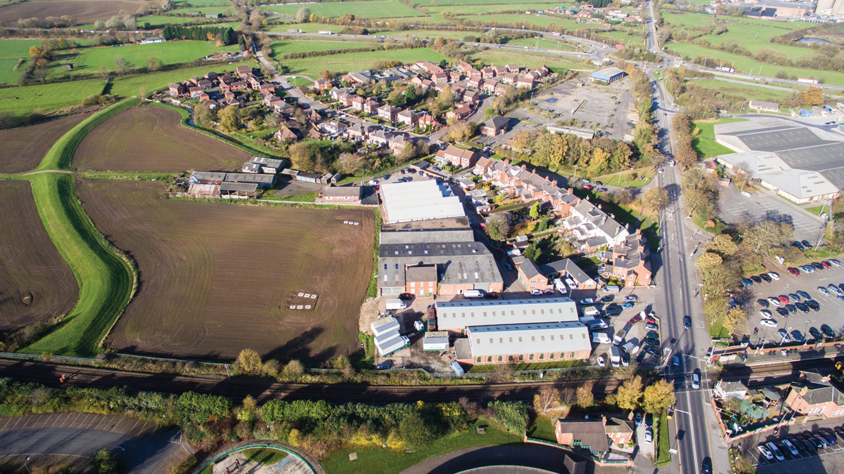
Overview of the Kelham Road catchment with adjacent farm land which was subsequently utilised for storage tank installation - Courtesy of NMCNomenca (now Galliford Try)
As a result of long term flooding problems in Newark, Severn Trent Water set up and now chair the Newark Flood Forum in order to work closely with national and local government agencies and the wider Newark community, including those directly affected by flooding. The purpose of the forum is to ensure that the views and issues of those at risk of flooding are taken into account in the development of solutions to the flooding issues in the town and that proposed works are communicated effectively. Through the flood forum it became clear that focus needed to be put into developing a solution to a complex flooding issue on Kelham Road to the west of the town.
Project background and drivers
Kelham Road is a residential street situated to the east of the River Trent in Newark, Nottinghamshire, approximately 500m from the town centre. Properties have suffered from long term internal and external flooding. In order to understand and resolve the complex flooding mechanisms, Severn Trent Water (STW) led a team of multiple agencies to put in place a holistic solution to address flood risk from all sources. The area is served by STW sewers, NCC highway drains, Trent Valley Internal Drainage Board (TVIDB) drains and is within an Environment Agency (EA) Flood Bund. There were known to be frequent internal (1 (No.) annual) and external (9 (No.) annual) flooding incidents.
It was clear from the outset that a lack of hydraulic capacity in the sewerage system was a key contributory factor to the flooding; however it was also clear that overall the flooding mechanisms were complex. Understanding which organisations had responsibility was initially difficult to determine and a team of key flood forum members, led by Severn Trent Water (STW) and NMCNomenca (now Galliford Try), came together to understand, develop and deliver a solution to the issues.
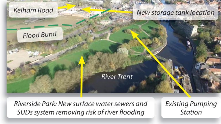
Project overview – Courtesy of NMCNomenca
Flood risk identification
Through collaboration, regular communication and information sharing amongst the team, the flooding mechanisms were ultimately identified and understood, at risk identification stage the team undertook the following activities:
- Site surveys of the agencies local assets, CCTV survey data and historic flooding information collated.
- EA River Trent model/STW sewer model combined into holistic model.
- New ISIS model of Old Trent Dyke (IDB Drain) generated to understand contribution to flood mechanism and potential for use in solution.
- Historic customer/stakeholder contact information shared.
- Flow survey in sewers and river level monitoring.
The activities were resourced to be as efficient as possible for all agencies, such that surveys were coordinated, models were combined and a single repository was used for all information. An example of coordination was that the IDB vegetation clearance was undertaken earlier than originally programmed, in order to facilitate surveys of the public sewers in the area.
Regular flood forum meetings provided a strong level of motivation to the team as it kept focus on the clear goal: to solve members flooding problems and the positive impact that a solution would have on their lives. Regular project team meetings were also held to develop the holistic understanding to the flooding issues.
The team was able to clearly identify the flooding mechanisms which were found to be as follows:
- Lack of hydraulic capacity in public sewerage system on Kelham Road.
- Lack of hydraulic capacity in highway drains on Kelham Road.
- Surcharge from STW’s Tolney Lane Pumping Station (PS) (downstream) backing up into the sewer Network.
- Highway gullies connecting to Tolney Lane PS, causing inundation of the PS and upstream system during times of River Flooding (River flooding outside of the flood bund, causing flooding inside the bund through the sewers).
- A third party discharge into the Old Trent Dyke which did not have a non return valve/flap valve resulting in inundation of the sewer system when the water level was high in the Dyke.
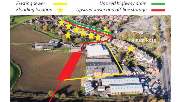
The designed flood alleviation project, taking flows from the existing system and into the off-line storage tanks – Courtesy of NMCNomenca
Solution development
A solution was needed which would be hydraulically sufficient to address all of the aforementioned flooding mechanisms. This would require continued input from all agencies as well as from Newark and Sherwood District Council (NSDC). As the solution benefited from being constructed partially on their parkland, NSDC became a key team member and provided input and helped develop various solution options to best suit their future amenity usage of the park.
The team worked together to determine the most cost efficient and customer driven solution and it was agreed that in order to alleviate flooding to the satisfaction of all represented agencies, the solution would need to comprise of the following:
- Upsizing sewers and providing online storage (264m3) for flows in excess of the downstream STW PS capacity, with flows returned to the downstream system once capacities allowed. The storage tank was to be constructed in agricultural land situated adjacent to Kelham Road.
- The existing NCC highway drains on Kelham Road would be upsized to mitigate the risk of highway flooding.
- Surface water separation would be provided downstream (Tolney Lane) to remove the risk of inundation of the sewer system during river flooding. The surface water from highway gullies would be discharged to the River Trent via a new SUDS system within NSDC’s Riverside Park. This also provided a 30% reduction of existing run off rates into the river. A flap valve would be installed on the Old Trent Dyke outfall to prevent inundation.
- Future flood risk policy in the area would take into account the known constraints (for example, in responding as consultees to future planning applications).
These solutions were agreed by all parties represented in the team and the full scope of works agreed.
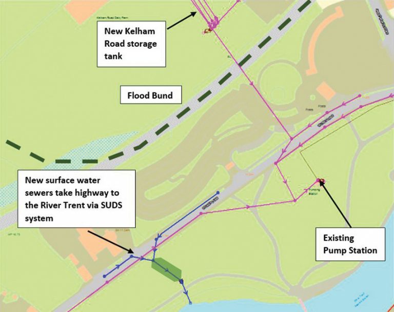
Highway flow removed from the surcharged drainage system and taken direct to the River Trent – Courtesy of NMCNomenca
Detailed design and construction
In order to deliver the works a partnership project was set up between STW, NMCN and NCC, with the consultation and co-operation of the EA and the TVIDB, as it was understood from the outset that greater efficiencies would be achieved if the works continued to be undertaken with a collaborative approach.
In July 2015 Severn Trent Water, Nottinghamshire County Council and NMCNomenca commenced the flood alleviation project on site. The solution was designed to resolve and eliminate the foul water flooding up to a 1 in 40 year rainfall event and the risk of highway flooding to 1 in 20 years to reduce the risk of flooding overall to properties on Kelham Road. The highway works were funded by NCC who paid directly to STW, this was then added to the works order to NMCN.
Formal flood defence consents were granted prior to commencement of construction and monthly progress meetings continued thereafter until project completion.
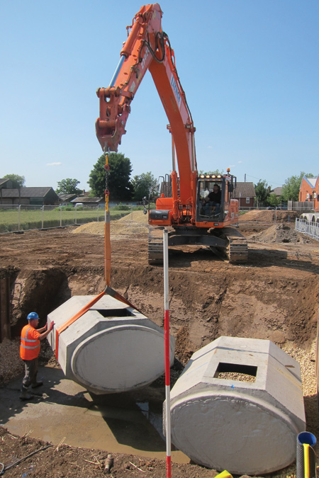
Installation of the Stanton Bonna combined sewer storage tanks – Courtesy of NMCNomenca
Investigations revealed that the presence of a number of utility providers’ apparatus prohibited the upsizing of the existing highway drain without a large amount of excavation works and disruption. Therefore, the detailed solution design resulted in the installation of 300m of drainage kerbs which provided the required capacity without the necessity for utility service diversions.
Impact to the customers and wider community was reduced by undertaking the sewer, highway drainage works and river flood protection works simultaneously. Financial efficiencies were achieved by utilising the same site set up, traffic management, plant and labour. This allowed the construction period to be reduced, thereby reducing disruption to the wider community even further. Details of the collaborative project were outlined within the advanced notifications and customer consultation process carried out by STW and NMCN.
Additional benefit to the customers was also delivered in the repair and upgrade of several sections of Kelham Road footpath, that were originally scheduled in NCC’s maintenance programme for 2016. The installation of the drainage kerbs and footpath re-construction, whilst carried out by NMCN, was supervised by NCC.
The required online storage was provided by 3 (No.) 1950mm x 1150mm elliptical pipes (50m in length) laid alongside each other and connected so that they fill and empty sequentially. The existing sewers in Kelham Road were re-laid on-line and upsized, with a bifurcation created to take excess storm flows into the storage tanks.

Complex Flooding Mechanism with Multiple Agency Involvement – Courtesy of NMCNomenca
Continual Improvement
The innovative collaborative approach taken on this project is being used as an example of best practice both within the agencies described above and to a wider audience. To date the approach and its successful resolution to the flood risk in the area has been shared through innovation bulletins internally and also presented to the following external organisations and bodies:
- Trent Valley Regional Flood & Coastal Committee (Jan 16).
- CIWEM Urban Drainage Group (Feb 16).
- China Tianjin Environmental Protection Bureau (Feb 16).
- ICE East Midlands presentation (lined up for May 2016).


