Glasgow’s Smart Canal (2022)
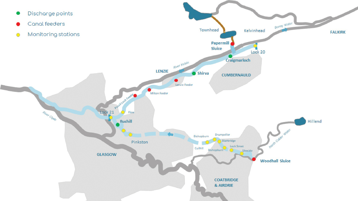
Schematic of NGIWMS infrastructure - Courtesy of AECOM
The North Glasgow Integrated Water Management System (NGIWMS), Glasgow’s Smart Canal, has created a pioneering drainage system, incorporating the historic Forth and Clyde Canal to provide one of the first autonomous and dynamically managed surface water systems in the world. The new system is supporting the regeneration of an area in north Glasgow enabling the development of over 3000 new homes within an area that would otherwise be constrained due to a lack of drainage capacity. The concept is based upon proactively lowering the summit pound of the canal ahead of a storm event, on the basis of forecast data, to then provide sufficient storage for the surface water discharges from new developments. Following the rainfall event, treated surface runoff from the developments drains into the canal, returning the water level back to the normal operating level.
Overview of the Forth & Clyde Canal
The Forth & Clyde Canal, being the world’s first sea to sea navigation which opened in 1790, is 35 miles of navigable waterway, running from Bowling in west Glasgow, to Grangemouth in the east. The summit pound runs from Maryhill Lock 21 in north Glasgow, to Wynford Lock 20 to the east. In total the summit pound is around 30km long and approximately 15m wide, giving it a large area of around 450,000m2. There is little variation in water level along its length and it is this hydraulic characteristic that makes the canal a perfect receptacle for surface water drainage as it acts like a storage reservoir.
Much like a reservoir, the canal also has a number of fixed overflow weirs, named as ‘waste weirs’ due to wasted resource, which regulate canal levels by discharging flows from the canal into nearby watercourses when water levels in the canal are high.
There are two main controlled feeders to the summit pound; at Craigmarloch in the north, and Woodhall sluices in the south. These two feeders have existing sluice gates which allow the canal operatives to increase or decrease inflow to control the canal top water level.
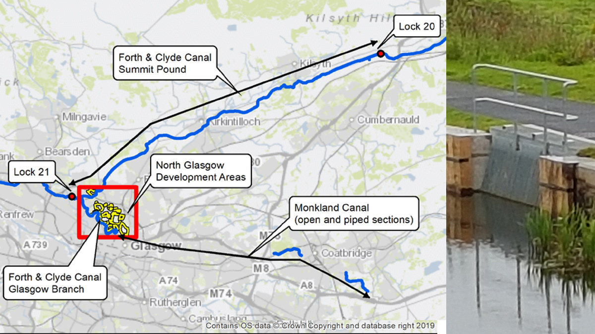
(left) Forth & Clyde Canal Summit Pound – Courtesy of AECOM and (right) discharge sluice at Craigmarloch – Courtesy of MacKenzie Construction
Glasgow’s Smart Canal – key participants
The project was designed and developed by AECOM in conjunction with Scottish Canals, Glasgow City Council and Scottish Water and has taken over 10 years, from initial concept in 2012 to achieve the collaborative agreements and funding necessary to see the project through to construction and operations. Funding was secured from diverse streams, including Glasgow City Deal, the Green Infrastructure Fund and Smart Cities Scotland.
- Designer: AECOM
- Main contractor: Mackenzie Construction
- SCADA sub-contractor: Fairfield Control Systems
- ICMLive hydraulic modelling software: Innovyze
Overview of the Smart Canal system
The concept was to create sufficient storage in the canal in advance of a storm event to accept stormwater runoff from new regeneration and development areas which then returns the canal to its normal operating level by the end of a storm. This preemptive drawdown must not increase flooding elsewhere, have minimal impact on navigation, and not to waste water which could have a subsequent impact on abstraction license conditions.
The system uses a real-time hydraulic model in ICMLive software that receives forecast rainfall data and canal status information from a SCADA network. The model predicts the storage required and sends commands to the SCADA network to automatically lower canal water levels using actuated sluice gates in advance of a storm event.
In order to draw the canal down, three discharge locations have been constructed on the canal at sites of existing waste weirs, at Ruchill on the Glasgow Branch, and Shirva and Craigmarloch on the summit pound. Actuated sluice valves open at the discharge points and feed water from the canal into the existing waste weir outlet channels that discharge flow to the River Kelvin. The system also includes automated control of abstractions that feed flow into the canal at Woodhall and Craigmarloch. During normal operation, the default positions of the discharge sluices are closed, and the feeder sluices open.
System infrastructure
The infrastructure supporting the NGIWMS consists of three actuated discharge gates, two actuated feeders and 23 monitoring stations forming the SCADA network, including a range of water quality monitoring locations.
Discharge and feeder control structures
The three discharge structures are located at sites of existing waste weirs, at Ruchill, Shirva and Craigmarloch. Each discharge structure is identical and consists of a 3m long lateral weir located at the canal bank, the crest level of which is physically set at 0.2m below normal canal operating level, reducing the risk of exceeding the operational changes. The weir discharges flow from the canal into a chamber.
A sluice gate controls flow from the chamber into a 600mm diameter pipe, that in turn discharges into the existing waste weir overflow channel. The sluice gates are actuated allowing the SCADA system to control gate openings, either manually, semi automatically or fully automatically. Maximum sluice gate opening is 0.5m, corresponding to a maximum discharge of approximately 0.13m3/s at each structure.
Control system architecture
The main elements of the system architecture are the rainfall data feed, real-time hydraulic model, SCADA network and SCADA database. Operator access to the SCADA database for Scottish Canals operations staff to view canal status information and manually override gate position commands is also provided.
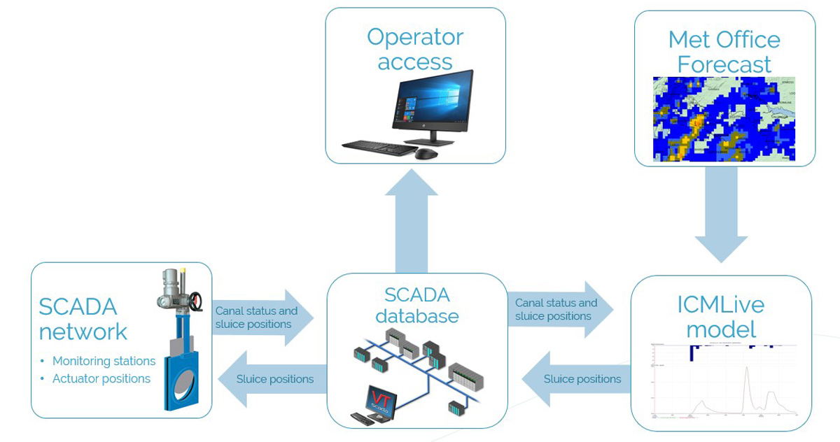
System architecture
Rainfall data
Forecast and observed rainfall data is supplied by the Meteorological Office. Forecast rainfall data is hourly deterministic forecast at 1.5km resolution, updated every 3-hours for a 48-hour forecast period. Observed rainfall data (used mainly for model calibration) is 1km resolution NIMROD radar data supplied at 5-minute frequency.
Live hydraulic model
The hydraulic model of the canal is a 1D/2D fully hydrodynamic numerical model of the Forth & Clyde Canal system. The model represents a digital twin of the canal and is constructed in ICMLive software supplied by Innovyze. The model uses forecast rainfall and current canal status information from the SCADA network to predict the canal’s response to storm events and determine appropriate actions which are then relayed to the SCADA database, which in turn are then relayed to the SCADA network.
The model includes representation of areas that naturally drain to the canal. These are included as 2D infiltration zones with direct rainfall input from forecast or observed rainfall (used for calibration activities). Also represented are controlled and uncontrolled feeders, existing waste weirs, new discharge structures and lock gates. Direct rainfall on the canal surface is included, as well as representation of losses from the canal through evaporation, seepage and gate leakage. As surface water connections from developments are constructed, the model will also include representation of the development drainage networks and SUDS features.
A simple hydrological model of the areas contributing inflow to the canal has been built, which runs much faster than the full hydraulic model. Currently the model manifest is set up such that the hydrological model is run every 3-hours as new forecast data are received. The hydrological model provides a figure for the total runoff volume expected to enter the canal over the forecast period of 48-hours. A full hydraulic model run is triggered in the event that the hydrological model detects sufficient storm runoff. The hydraulic model uses the runoff volume to predict a target canal level to provide sufficient storage for 80% of that volume. Setting a target level based on a percentage of the predicted volume provides a buffer to account for any forecast or modelling inaccuracy and ensures that the canal level is not left below normal operating level at the end of the storm.
Control philosophy
The control philosophy has to balance several conflicting factors such as minimising water wastage, maintaining navigation by canal traffic, and the consideration of forecast accuracy. Accuracy decreases as the forecast period increases, however drawdown of the canal takes a long time – approximately 18-hours to drawdown 100mm if all discharge sluices are fully open. If the canal is drawn down too far in advance, there is a risk that the predicted inflow to the canal will be inaccurate and either too much or too little storage provided. Delaying drawdown risks not reaching the required level in time. Both could lead to insufficient flood mitigation or significant water wastage.
The model uses real-time-control (RTC) to regulate the canal level to the target set point based on a set of logic rules to close the feeder gates and incrementally open the discharge gates at a given timestamp. The set point is updated every 3-hours with each model run. This enables the full dynamic capability of the software to be used by allowing live adjustments to be made as more accurate forecasts are received.
The following figures show an illustration of the control philosophy.
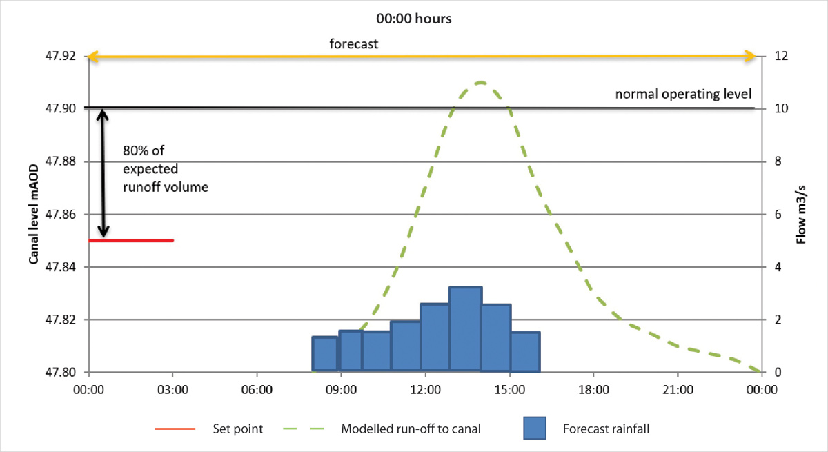
Storm forecast at 08:00, the model sets target level based on 80% of expected volume, RTC logic control determines the combination of feeder and discharge gate positions required to achieve this target level
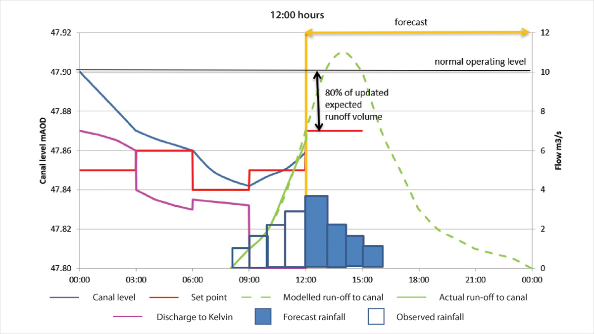
Storm is on-going and runoff is entering the canal. Only 50% of the storm is visible to the hydrological model so the expected volume decreases, and the target level increases and the RTC regulates the gate positions to reach and maintain that target level
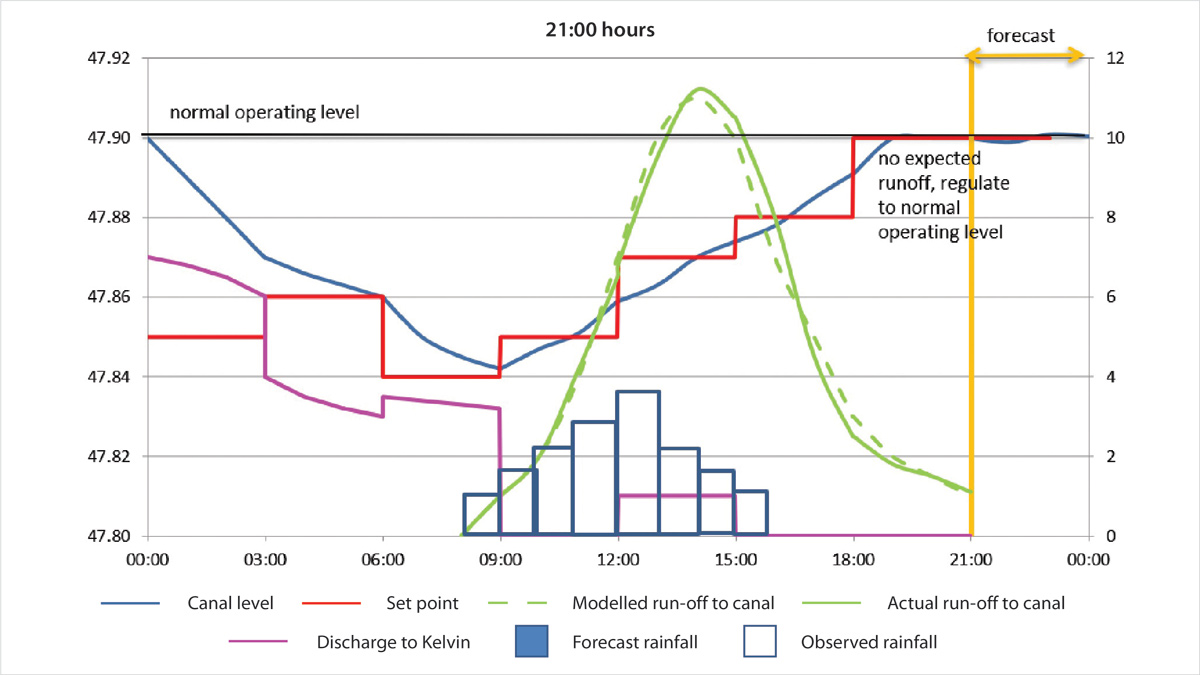
The storm has finished, the model sees no forecast rainfall so with no runoff predicted, the RTC regulates the gate positions to the normal operating level
Scheme benefits
In addition to providing surface water management and unlocking the regeneration of the North Glasgow development areas, the scheme also provides water quality monitoring and habitat improvements along with place creation and business opportunities for local communities. This approach has also delivered significant cost and CO2e savings in comparison to traditional engineering solutions. A traditional infrastructure intervention would have required substantial engineering and significantly higher capital investment costs in the region of £45m and is estimated to avoid in the region of 35,000t CO2e through its 60-year design life.
Summary
Glasgow’s Smart canal is one of the first autonomous and dynamically managed surface water systems in the world and remains unique in terms of scale and approach. There are no examples of canals or scheduled monuments being utilised an equivalent level for climate change adaptation and net zero climate contributions.
The scheme demonstrates how state-of-the-art technology, combined with the heritage of a 250-year-old canal, can surpass traditional drainage solutions. This approach has benefitted the community in terms of cost savings, commercial opportunities (as detailed in the Glasgow North Strategic Development Framework), climate change adaptation, biodiversity and reduced environmental impact.
As climate change and flood risk become increasingly important factors in surface water management and urban resilience, the potential to adopt this approach in other contexts is considerable.
This project has shown how the combination of technology and engineering can enable legacy assets to further contribute to the fabric of civil infrastructure, providing carbon and cost savings and enabling regeneration and growth in previously landlocked areas.
UPDATE!
In June 2022, the Glasgow Smart Canal project scooped the Surface Water Management Award at the Flood and Coast Excellence Awards held by the EA in Telford, UK. Congratulations to the team!
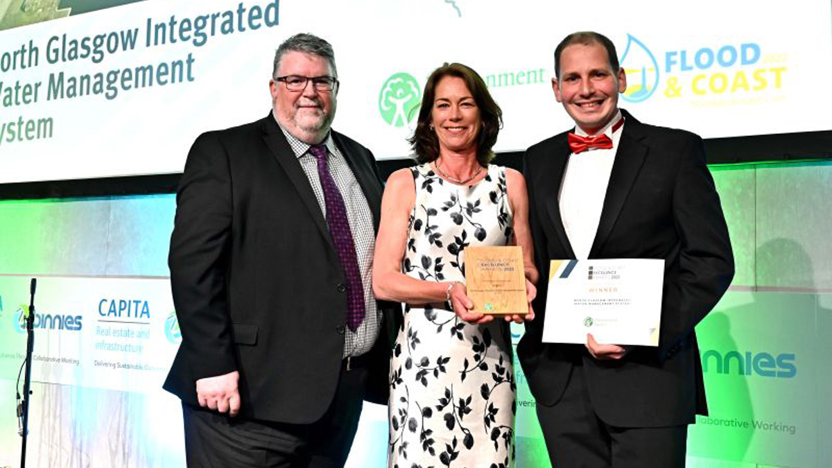
Pictured is AECOM’s Principal Engineer Debbie Hay-Smith along with Jamie Cobb from Fairfield Control Systems Ltd, collecting the award from Ian Hodge of the Environment Agency.


