Highways England Area 13 Flood Risk Reduction (2019)
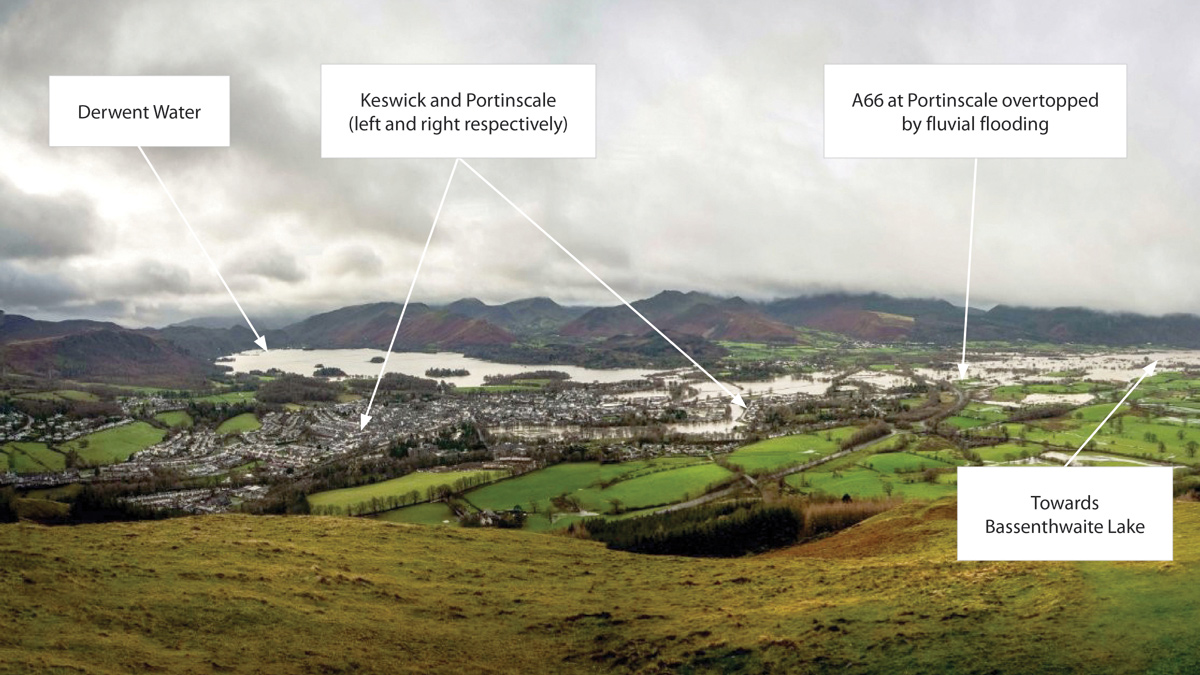
View of Keswick flooding during Storm Desmond (6 December 2015) with A66 situated towards centre of photograph (source: National trust 2019). Flooding was so extensive that Derwent Water and Bassenthwaite Lake usually 4km apart were joined by the River Derwent and Newlands Beck floodplains, with the A66 road being overtopped at locations throughout Keswick (in particular Portinscale) - Courtesy of Highways England
Keswick and the surrounding area within the Lake District National Park has suffered severely from recent flood events. Most recently, Storm Desmond (2015) resulted in approximately 500 flooded properties and disruption to the A66 trunk road, a key national and strategic link for east/west journeys in the North of England. The A66 is situated close to the River Derwent and several key tributary watercourses that have been subject to historical flooding. Records dating back to the 18th century, and the most recent flooding caused by Storm Desmond, have brought the area back into focus. Direct flood damages in the Lake District area totalled £500m.
Background
The Pitt Review (2008) identified road locations including the A66 near Portinscale in need of upgrade to improve the assets flood risk resilience amongst other key drivers (disruption, economy, access and egress etc).
The focus of this project, working alongside Highways England and Amey Consulting, has been to reduce flood risk to the A66 trunk road that runs from Scotch Corner (North Yorkshire) to Cockermouth (Cumbria) via Keswick.
- The Environment Agency (Flooding in England A National Assessment of Flood Risk, 2009) estimate that 10% of main roads are in areas at risk from flooding; with two thirds being at moderate or significant risk. Therefore, flooding has the potential to cause significant damage to roads and disruption to both travellers and businesses with the resulting losses being some of the highest non-property losses from flooding experienced 1.
- During Storm Desmond the EA estimated UK road closures had an economic impact of £220m (£165-£275m estimate range) throughout the UK.
- Indirect flood damages in the area as a result of road closures and negative impacts on the wider economy may have been in the region of £1-2bn (Cumbria reported downturn of 76% on typical annual £3bn revenue following Storm Desmond 4 months on from the event).
1 Flood Hazard Research Centre, Middlesex University, 2014.
Key drivers
There are several key drivers for the A66 highway improvement scheme at Portinscale which Highways England keen to investigate, to improve the reliability of the strategic road network with the overarching factor being resilience to flood risk. The key drivers are summarised below:
- Annual probability of a flood event at the A66 road which causes traffic disruption is considered to be the 1% AEP and greater (based on existing EA hydraulic model results). Future climate change is likely to exacerbate this and the road is to be made resilient to this.
- Reduction of the cost of traffic disruption – i.e. cost is a function of the flood duration/depth and the number of roads (and their importance) which are impassable during a flood.
- Consideration for alternative routes should a major road be closed for days rather than hours.
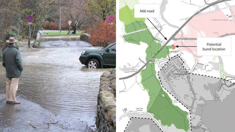
(left) Flooding at a Keswick County Road in Portinscale during with the junction of the A66 near 2009 (E: 324715 N: 523680) Source: Geograph.org.uk 2019 (John Proctor) – Courtesy of Highways England and (right) potential bund location preventing cross-flow from the Derwent catchment into the Pow Beck and Newland Beck catchment, reduces flood depth to the A66. Note widespread minor increase in depth but this is generally to fields and the option could be optimised to improve this
Approach
Flooding to the A66 at Portinscale is a well-known issue, identified as a significant receptor to flood risk by the 2008 Pitt report (Pitt Site 64), however the route cause was still to be determined. The location flooded significantly during the 2015 Storm Desmond due to flooding from the River Derwent and tributary watercourses which resulted in diversions along smaller county roads and in some locations no access/egress to areas of the Lake District.
Highways England (HE) have been investigating potential improvement works to the A66 at Portinscale to increase reliability, regional and national connectivity, air quality, access to key tourist destinations with a key driver being resilience to flood risk.
Working in partnership with Amey, Waterco further developed existing hydraulic models and improved them using data provided by the EA and obtained from additional sources, to inform optioneering.
A66 at Portinscale key study
Waterco were instructed by Amey to review flood modelling for the A66 at Portinscale that was undertaken by a previous consultant in 2015 and 2016.
Upon undertaking the review of the site-specific modelling and gaining better understanding of hydrological interaction of catchments in the area, it was evident that a wider understanding of the catchments local to the A66 needed to be investigated. There were four main considerations which needed further investigation:
- The EA released new climate change (CC) allowances for river flows in February 2016. The ‘Upper End’ 100 year design lifetime climate change allowance was selected for the A66 (essential infrastructure) i.e a 70% increase to the calculated 1% AEP peak flow (1% AEP + 70% CC). The previous modelling considered a 20% allowance.
- Previous flood modelling focused on watercourses and structures in close proximity to the A66 despite there being cross-catchment flow between River Derwent, Newlands Beck, Pow Beck and Coledale Beck.
- Keswick, Braithwaite and the wider area are other key flood risk locations that the EA are also investigating to alleviate flood risk which have the potential to further impact the understanding of the flood risk to the A66 at Portinscale.
- Suggested options to alleviate flooding of the A66 included raising the highway and larger conveyance features under the road at Pow Beck and Newlands Beck although the localised model extent had not considered the wider impact of the options. (i.e. cross-catchment interaction).
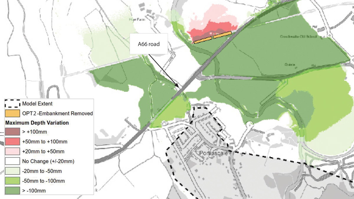
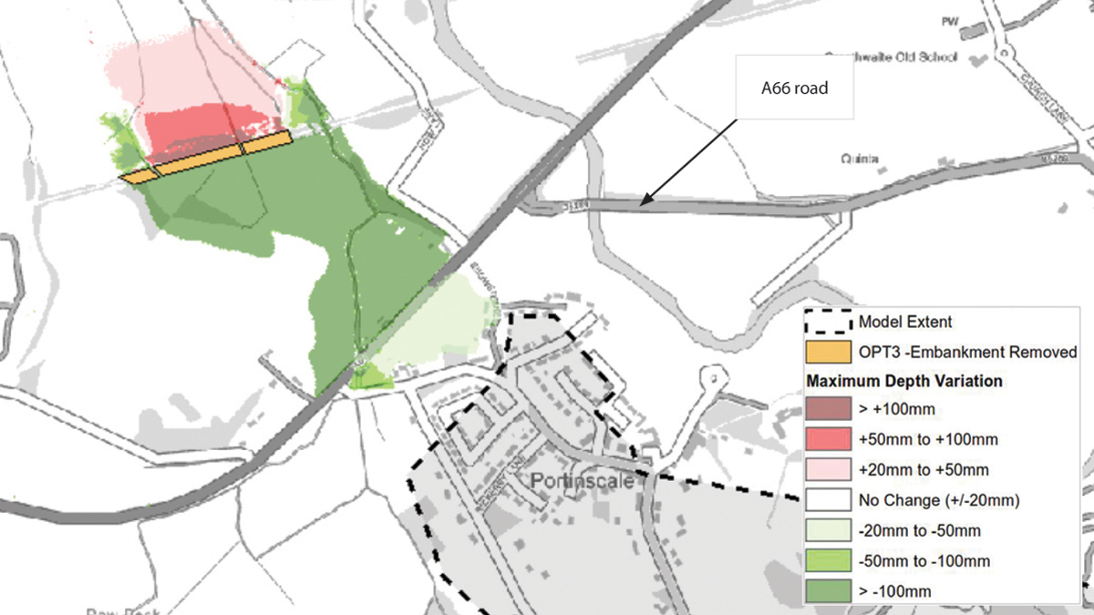
Screenshot of depth difference mapping showing two disused railway embankment removal options and the potential impact on flood depth when compared to the existing model results, flood depth at A66 shown to decrease. Location 1 – Courtesy of Waterco
HE and EA shared modelling
Following initial modelling exercises and meetings attended by Waterco, it was established that the EA were reviewing flood risk issues in several key areas near to the A66. The EA are investigating a key potential flood alleviation scheme at Braithwaite, situated along Barrow Gill and Coledale Beck west of (and upstream from) the A66 at Portinscale.
The EA’s aim is to remove flood risk to 40 properties in the village of Braithwaite which was independent of HE’s aim to reduce flooding along the A66.
Following joint meetings both hosted and attended by Waterco, Amey, HE, the EA and occasionally third party stakeholders/land owners, it was agreed that findings and information (including Waterco modelling) would be shared across the organisations to improve knowledge and aid decision making for third party schemes such as the EA’s Braithwaite Flood Defence Scheme.
EA’s Braithwaite Scheme and importance of a wider catchment understanding
The need for a homogenous approach to flood risk in the wider area was highlighted to Waterco through discussion with HE and the EA following initial model runs which included the EA Braithwaite flood alleviation design (2018). The scheme had been assessed using a smaller site-specific model than the updated Waterco modelling and did not fully quantify the impact of pass-forward flow.
This EA scheme originally provided a 1.33% annual exceedance probability (AEP) standard of protection (SOP). The scheme included linear defences comprising traditional and glass flood wall structures along sections of Barrow Gill and Coledale Beck and a reinforced concrete structure upstream of existing bridge structure ‘Low Bridge’ to ensure no additional loading. Working in partnership with HE the scheme is being revised to also remove flood risk to the A66 north of Braithwaite during the 1% AEP + 70% CC fluvial event.
Impact of hydrology approach chosen for A66 on the Braithwaite Scheme
To inform the EA scheme at Braithwaite, a 3.7 hour storm duration was utilised, the duration is shorter than the duration for the HE A66 assessment due to the town of Braithwaite being the critical location, i.e. only focusing on the Barrow Gill and Coledale Beck catchments and not considering the impact of the Newlands Beck catchment, a key downstream watercourse which is critical to flood risk at the A66. A storm duration critical to the area of Braithwaite. The A66 was chosen as the model downstream boundary location, and utilised an automatic rating curve allowing flood flows to leave the model without fully quantifying the impact to the A66.
When considering the longer 5 hour critical storm duration for the HE scheme and the increased design flow (1% AEP+70%) the Braithwaite scheme did reduce flood depths to the A66 downstream of Braithwaite by around 60mm. However, the pass-forward flow increased flood depths to the A66 at Portinscale by around 60mm, increased the number of other locations which experienced flooding and/or experienced greater flood depths. The impact of the pass-forward flow could not have been quantified utilising a site-specific model. The results from this exercise were shared with the EA who raised concerns with their design, which had not been fully considered previously.
New modelling software, hardware capability, existing and new model data
Waterco built a multi-catchment model of the study area incorporating existing models and new survey data. Using newly available techniques, such as TUFLOW HPC solver and Graphics Processing Unit (GPU) hardware (up to 40x faster than Central Processing Unit (CPU) solvers), a large-scale single domain model was created- statistics are given in Table 1.
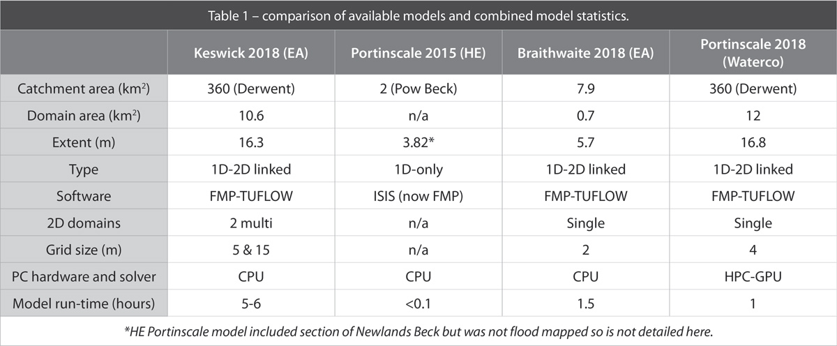
Table 1 – comparison of available models and combined model statistics
Hydrological approach
The hydrological methods used within the modelling incorporate the most up-to-date UK hydrological methods at the time of writing comprising several methods, including ReFH1, ReFH2, FEH-statistical (Enhanced Single Site (ESS) and ungauged) analysis. The EA recently completed hydrological studies for the Braithwaite catchment (Barrow Gill and Coledale Beck) and detailed assessments for the Derwent and the Newlands Beck. Waterco undertook a new hydrological assessment for the Pow Beck.
Location 2 – Courtesy of Waterco
Large scale model allowed greater understanding of baseline and faster appraisal
HE had early on identified that their existing modelling did not capture the impact of the River Derwent over spilling into the Pow Beck floodplain at Portinscale. Waterco modelling confirmed that high flows in the Derwent would spill into the area south of the A66 and cause flooding to the road, identified as being a separate issue to the tributary watercourses.
The 1 hour simulation time has enabled quick assessment of the requirement for options to remove flood risk to the A66. Modelling has identified a potential 200m of land bunding between the Derwent and Pow Beck catchments can alleviate some of the cross-catchment flooding to the A66 and around 10 properties at Portinscale.
Through removal of a section of disused railway embankment north of the A66, additional flow which backs up from bunding could be propagated away from high risk receptors (i.e. roads/properties). Modelling identified raising of the road where Pow Beck passes beneath the A66 could remove flood risk to the road itself. Flood relief culverts beneath the A66 may also be required to ensure flood risk elsewhere is not impacted by any road raising.
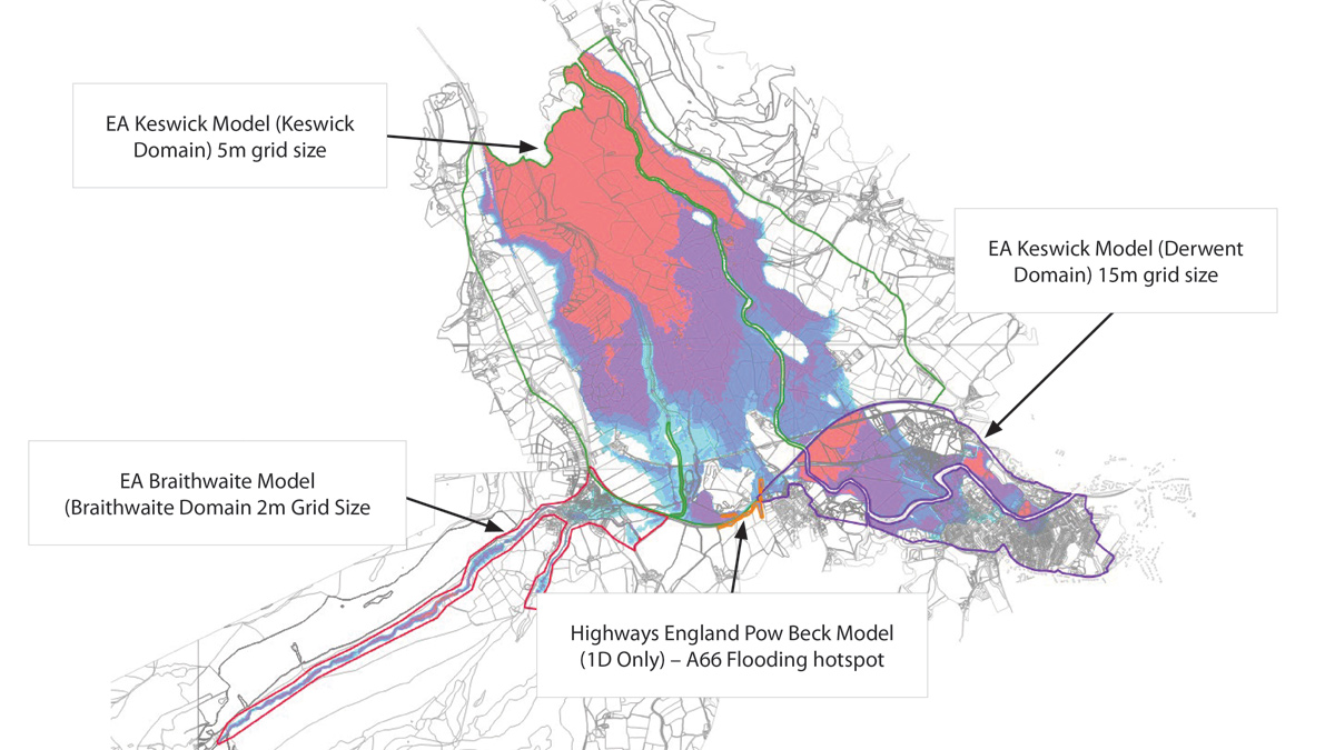
Location of existing model extents and flood extents generated by models – Courtesy of Waterco
Limitations of modelling and issues encountered
Although the benefits of the multi-catchment model are evident through observations of different options having a cross-catchment affect (e.g. Braithwaite scheme having an impact on the Newlands Beck at the A66), significant changes to model grid size introduce issues with hydraulic model stability and 1D/2D link location representation.
The 4m grid size used is considered high resolution considering the domain size (870k 2D cells in total), due to flood risk to the A66 occurring from smaller watercourses i.e. the Pow Beck, 1D/2D link locations were drowned by the 2D water levels which leads to numerical instabilities in the model.
Reducing the grid size of existing models also means shifting the 1D/2D link locations slightly to ensure accurate representation, the combination of these two issues required significant development time to stabilise the model.
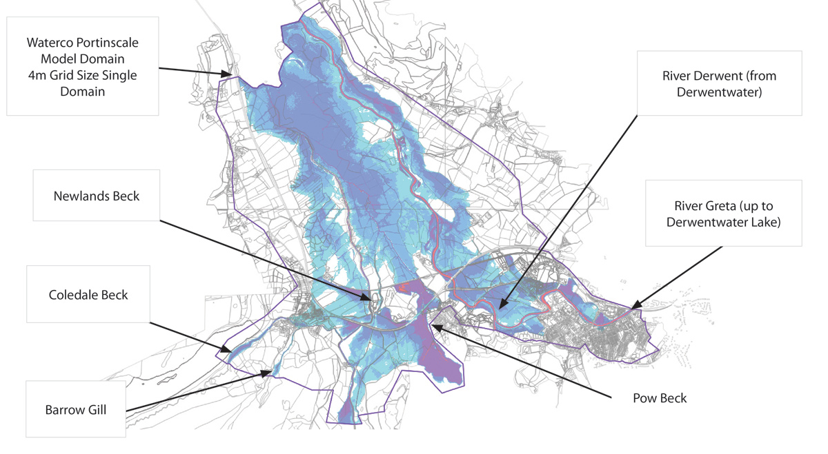
Combined single domain 4m model of Portinscale area with flood extent – Courtesy of Waterco
Design and construction programme
Feasibility study of the scheme is still on going and a preferred solution is yet to be decided upon. However, the preferred solution is likely to include innovative solutions such as embankment removal and land raising, away from the A66 road to avoid the requirement for major road works e.g. raising the road carriageway.
Amey and HE have confirmed that two potential major road work schemes, which involve raising the A66 road at Braithwaite and at Portinscale are still being considered and may be taken forward.
The Construction programme will be confirmed once the scheme has been awarded following the detailed design stage.


