
Tees & Central Strategic Pipeline: Phases 1 & 2 (2023)
Shaft construction from east shaft looking west - Courtesy of Farrans
With approximately 60km of new 800/900mm pipeline required to replace the existing potable water mains, some of which are over 150 years old, the Tees and Central Strategic Pipeline will directly improve water quality, network resilience and operability within the Tees Network. The pipeline will serve approximately 50,000 properties and link a number of strategic assets serving the Barnard Castle, Darlington and Teesside conurbations, providing significant resilience to the overall system by 2028. The scheme will provide strategic connections between Lartington Water Treatment Works (WTW) and the existing service reservoirs (SRs) at Whorley, Shildon, Beaumont Hill and Long Newton. The works are being phased over two AMP cycles with Phase 1 currently under construction and Phase 2 in the definition stage. The scheme forms part of NWG’s wider Tees Network Strategy with further improvements to follow.
Project organisation
Northumbrian Water Group’s (NWG) framework technical design and design and construction delivery partners, Mott MacDonald, Stantec UK, Mott MacDonald Bentley and Esh-Stantec, are working together as part of a collaborative team called IDeA (Integrated Delivery Alliance) to deliver a major infrastructure project spanning across Darlington and County Durham.
A key focus throughout the multi-disciplinary project has been effective collaboration which has been aided by involvement from specialist companies such as Lichfields and Bell Ingram. Figure 1 (below) shows the project organogram for this project. The delivery methodology, design, and construction principles have been developed jointly by all parties in the IDeA team.
There have also been opportunities for carbon reduction by using low carbon water and a carefully considered material selection methodology.
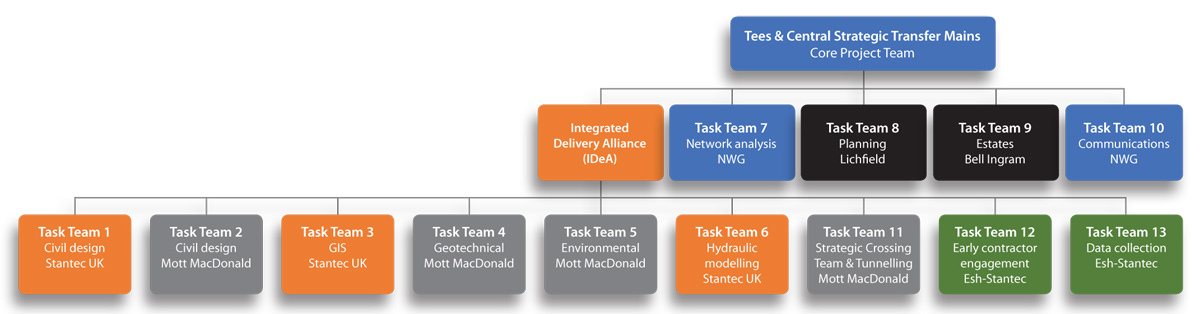
Figure 1: Project team organogram – Courtesy of IDeA
Project scope
In addition to the new pipeline, the scheme also involves the decommissioning and abandonment of over 80km of ageing pipeline as well as other assets including pipe bridges and booster pumping stations. To facilitate the abandonment of these assets, existing local networks will ultimately be connected to a combination of new or re-purposed pipelines, ensuring approximately 16,000 properties between central Darlington and Winston village to the west are among those that will benefit from the investment.
Carbon reduction
Carbon quantification has been an important part of the scheme in order to align with the transition towards a net zero carbon economy, and every attempt has been made to ensure the design solutions are not only hydraulically sound, but that carbon as well as total expenditure is reduced. NWG’s customers in this area are predominantly supplied from two water treatment works, depending upon prevailing supply and demand conditions:
- Lartington WTW: Source water is delivered under gravity into the water treatment works from upland impounding reservoirs and supplied into the potable water transmission network also via gravity.
- Broken Scar WTW: Source water is pumped from the River Tees into the works, treated and further pumped into the potable water transmission network.
Potable water supplied from Lartington WTW is therefore more energy efficient and the construction of the new pipeline allows NWG to maximise this more cost-efficient water by delivering it into key locations of the potable water supply network in lieu of water from Broken Scar WTW, which may have passed through up to three water pumping stations.
Typically, this will mean energy savings on the production and distribution of up to 30 Ml/d of potable water.
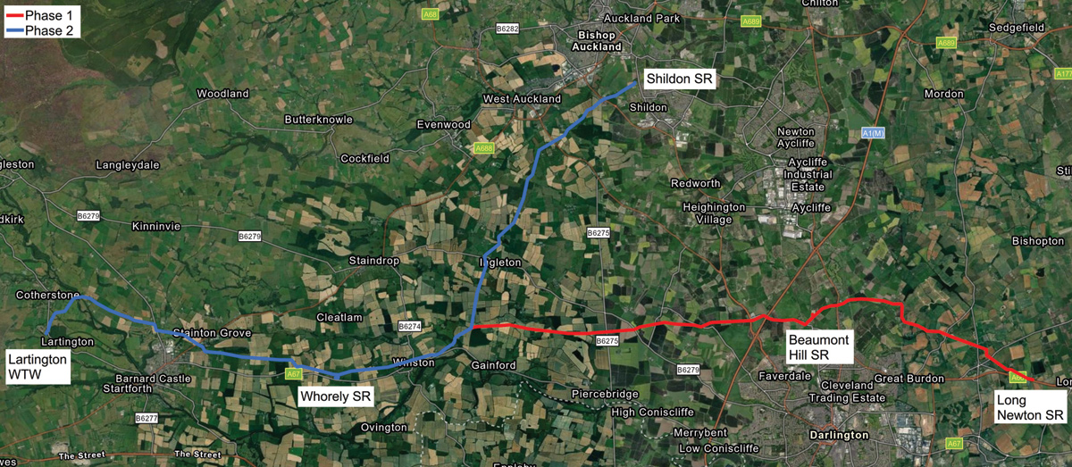
Figure 2: Overall pipeline schematic – Courtesy of IDeA
Design collaboration
To deliver technical excellence, the project team has worked closely with NWG’s network operatives, controllers, and analysts to help them enhance their network control and to provide future planning for resilience. Extensive hydraulic modelling and scenario planning has been undertaken to ensure the network is robust, can meet requirements to support other areas of the system to the north and east of the new strategic network, as well as meet future aspirations for enhancements in the downstream network.
Peer reviews of all design aspects is a continuous process on this project, utilising technical expertise from all parties. Design reviews are scheduled weekly to engage with NWG’s wider project team as well as internally within the IDeA team, meaning there is early challenge of key design aspects and collaboration to innovate and use best practice on technical issues.
IDeA have been appointed as Principal Designer to ensure that CDM 2015 (Construction Design & Management Regulations 2015) is adhered too.
IDeA has used the reach-back into their two parent organisations to maximise innovation, technical best practice, and the use of digital tools to assist in optimisation of the alignment, carbon assessment and delivery of the common data environment (CDE).
ArcGIS online
ArcGIS has been used as a CDE for this project to ensure the project team has a single source of information for making and recording design decisions. This software application was selected due its visual, interactive and geospatial environment.
Geo-environmental constraints mapping, aerial photogrammetry, route alignments, utilities, local development information, hazards and design decisions are all recorded within the CDE allowing various data sets to be displayed across several geospatial maps. Alignment adjustments made within the CDE are immediately shared with the rest of the project team ensuring the team has access to information that is up to date, accurate and relevant.
This CDE was also used to host the data for tenderers for Phase 1 to ensure they were provided with a common platform of information, see Figure 3 (below).
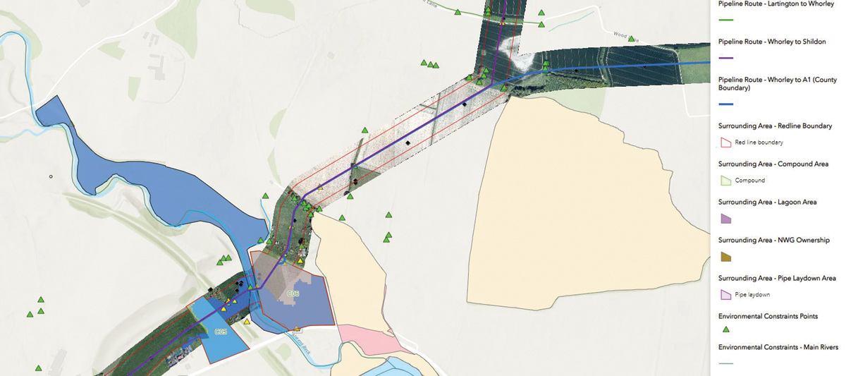
Figure 3: Phase 1 ArcGIS online tender package – Courtesy of IDeA
Stakeholder engagement
Engaging and communicating with stakeholders at the earliest opportunity has been critical to moving the project forward. IDeA and NWG’s communications team have worked together to ensure a wide range of stakeholders have had early sight of the project including local MPs, affected councils, Environment Agency and local wildlife trusts, with letter drops and planning consultation drop-ins. IDeA has worked alongside Bell Ingram and NWG’s Estates team, to deliver early consultation and land entry notices to over 150 different landowners and their tenants impacted by the pipeline route and the significant associated site investigation works. These have included environmental/ecological surveys, ground investigation, geophysical surveys, and archaeological trial trenching. This collaboration is continuing throughout the concept design and definition stage of Phase 2 of the project.
The outputs from the CDE have enhanced stakeholder engagement, allowing stakeholders to understand the scale of the project and the full constraints requiring the chosen alignment. The CDE has also been used to assist with the creation and management of land entry notices across the full scheme.
Health, safety and environment
There has been an extensive hazard logging process during the project concept and definition phases, using data sources such as NWG’s GIS system and from utility companies. Hazards in the vicinity of proposed works have been logged within the CDE, assigned a risk significance, and then fed into design decisions across the scheme; this process has been made more collaborative and visible by using CDE and easier to pass on into the detailed design and construction phases, see Figure 4 (below).
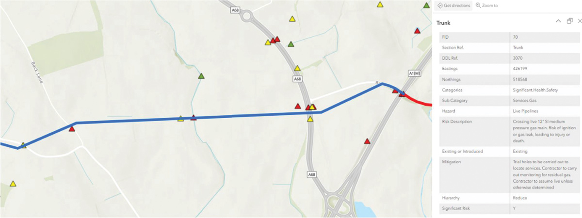
Figure 4: Hazards recorded and managed within a geospatial CDE – Courtesy of IDeA
Planning and environmental impact assessment
Due to the scale of the works, planning permission is required for both phases of the main pipeline alongside an Environmental Impact Assessment (EIA). This work has required collaboration between the design teams, construction experts, the environmental and geotechnical teams and NWG’s planning consultants, Lichfields. The CDE has been used to collate the information for the EIA and has been instrumental in providing a visual platform to assist the team in defining the red line boundary to meet the requirements for the construction of the works, including working areas, access points, site laydown area and compounds. Planning permission has been granted for Phase 1 and is in process for Phase 2.
The planning documentation for Phase 2 is anticipated to be ready for submission in Q1 2024.
Design principles and key design aspects
To optimise the pipeline route, a number of guiding design principles have been utilised including keeping the route as short as possible, keeping a uniform gradient fall in the vertical alignment, maintaining the pipeline below the hydraulic grade-line and favouring curvature over formed bends to reduce headloss. Geo-environmental impacts have been minimised by avoiding areas of significant ecological or archaeological importance and avoiding high risk ground conditions and potential ground or groundwater contamination. The route alignment has also been developed carefully considering landowner and customer impacts.
Early engagement of material suppliers, ground investigation teams, early contractor engagement, and working closely with the environmental team has allowed IDeA to optimise the pipeline design and flag any potential hazards so design adjustments can be made with relative ease.
Lessons learnt from Phase 1 are being used for efficiency and best practice in design and specifications for Phase 2.
Steel was selected as the pipeline material via material selection matrix with input from suppliers, installers, world renowned technical specialists, NWG operational experience, as well as geotechnical, carbon and civil teams.
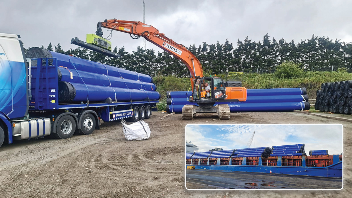
Delivery of steel pipes to the site and (inset) pipes arriving in the UK – Courtesy of FT Pipeline Systems
Tees & Central Strategic Pipeline: Supply chain – key participants
- Design – pipeline & tunnels: Mott MacDonald
- Design – pipeline & strategic connections: Stantec UK
- Planning consultants: Lichfields
- EIA: Mott MacDonald
- Land management consultant: Bell Ingram
- Land drainage design: Land Drainage Consultancy Ltd
- Design & construction: Farrans Construction
- Lead designer for Farrans: Atkins
- Tunnel design & construction subcontractors: Joseph Gallagher Ltd
- Pipe laying & associated welding: Grant Plant Hire Ltd
- Slide rail shoring: National Trench Safety UK
- Steel pipes: FT Pipeline Systems
- Pipe fittings: George Green (Keighley) Ltd
- Shaft segments: Macrete (Ireland) Ltd
- Tunnel precast pipes: FP McCann
Strategic crossings and connections
Strategic crossings and connections have all been identified, developed, reviewed, and enhanced with input from stakeholders from both NWG and IDeA through formalised design sprints, meetings and workshops. Resilience has been considered at every strategic crossing taking consideration of future maintenance access and redundancy of the system as a whole.
Crossings and tunnels
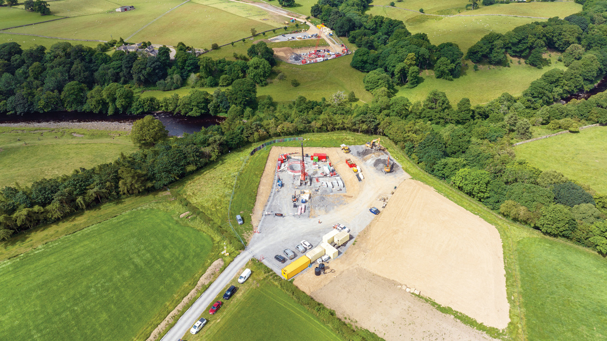
There are various major road crossings including the A1(M), three river crossings and two railway crossings. To determine the most suitable method of strategic crossing, all significant environmental, geotechnical and civil constraints have been carefully considered, with options being the subject of stakeholder review meetings. As a result of these discussions, tunnels have been proposed for one major road crossing, one river crossing and both railway crossings.
The tunnels are all proposed at 1.8m diameter and will contain twin pipes of 700mm diameter. Lengths range from 60m to 250m and depths from 8m to 50m. The remaining major road crossings will be open cut. The two river crossings are to be traversed by pipe bridges both approximately 25m in length.
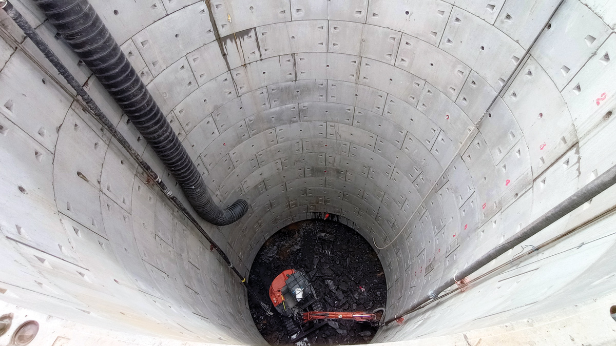
Tunnel shaft at the River Tees crossing – Courtesy of Mott MacDonald
Strategic connections into service reservoirs
Five service reservoir strategic connections are required to deliver this project, one at the WTW and the others to SRs, with the end result giving enhanced resilience and operability to the pipeline and network as a whole. Significant consideration and collaboration with NWG stakeholders has been undertaken for each connection to de-risk construction operations and avoid interruption to supply to a significant number of customers. New flow meters, turbidity monitoring and control valves will be installed on these connections to provide further monitoring and control, enabling more flexibility in control of the system and improve water quality and efficient movement of supply throughout the network, maximising operating efficiencies.
Reconnecting district metered areas
Due to the extensive abandonment of pipework required, 20 district metered areas (DMAs) (approximately 16,000 properties) require re-connection to an alternative water supply. The DMA works use a combination of re-purposing existing mains, laying new mains and abandoning pumped supplies in favour of pressure-managed gravity solutions. DMA enabling works were discussed as part of the early engagement with NWG including flow reversal, flushing and conditioning. A key priority in these discussions has been the commissioning and decommissioning sequence of individual elements of the reconnection works to ensure minimum customer and operational impact.
Asset abandonment and decommissioning
As for the reconnection works, the abandonment works could have significant customer impact without proper consideration of sequencing and significant collaboration with NWG operational staff. The abandonment works will be sequenced to suit the commissioning of the pipeline in Phase 1, the Phase 2 pipeline and the reconnection works in Darlington and the surrounding area. The abandonment works will require a number of interfaces with the existing network requiring double isolation, thrust restraints, asset removal and trunk main drain-down and de-chlorination. Consideration is also being made to the reduction in resilience in the hydraulic network once abandonment has taken place, with contingencies being developed so that reconnected DMAs can still be reliably supplied.
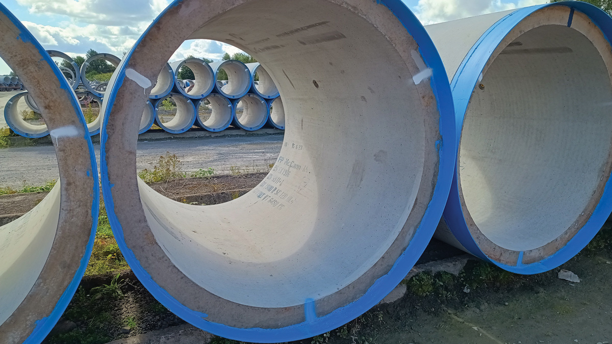
FP McCann jacking pipes – Courtesy of Mott MacDonald
Conclusion
At the time of writing (July 2023), Phase 1 of the project is under construction by Farrans Construction and the pipeline is expected to be in service by March 2025. The Phase 2 planning submission is anticipated to be made in Q1 2024, with detailed design and construction works starting in 2025. Lessons learnt from Phase 1 during the detailed design and construction phases will be used for efficiency and best practice in Phase 2. The collaborative environment created by the project team and use of ArcGIS as the CDE have enabled this project with multiple stakeholder interfaces to be delivered to efficiently and effectively. Where possible, the IDeA team involved in Phase 1 of the scheme have continued to support NWG in detailed design and construction and continued into development of the Phase 2 concept and design to retain project experience and carry lessons learnt forward throughout the project’s lifespan.