Battlefield Brook Fish Passage (2019)
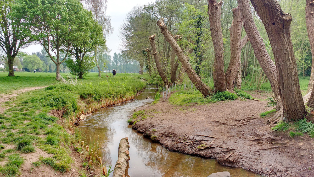
Phase 2: Coppiced trees, log flow diversion, brushwood faggots, planted coir rolls - Courtesy of Galliford Try
Battlefield Brook catchment encompasses farmland, Catshill Marsh (which used to be a Site of Importance for Nature Conservation; SINC), urbanised reaches adjacent to the M5 and Sanders Park; a public amenity facility owned by Bromsgrove District Council. The section of the brook through Sanders Park was lined with concrete in the 1960s. Despite its urbanised nature, Battlefield Brook is home to the largest viable water vole population in Worcestershire.
Background and problem description
An RSA investigation and impact assessment were completed in AMP5 and supported the need for sustainability reductions in the Battlefield Brook to address the cumulative impact of groundwater abstractions. A strategic solution (WRMP) and a local solution (NEP Implementation) were put forward by Severn Trent in the PR14 Business Plan and are designed to benefit flow in order to support Water Framework Directive (WFD) good ecological status.
The strategic solution (Bromsgrove GW scheme) is to implement sustainability reductions accompanied by resource replacement and optimisation of compensation flows. This was due to be implemented by the end of AMP7 due to its complexity. As an interim measure in AMP6 a local river restoration solution, this scheme, was implemented in order to make use of the water available and improve the local ecology. By targeting specific reaches this is intended to have immediate benefits for the Battlefield Brook.
Feasibility brief – options assessed & recommended solution
The Stage Plan for the hydro-morphology scheme, agreed by Severn Trent and the Environment Agency, set out the following objectives and deliverables for the scheme:
- Objective: for Severn Trent to contribute their fair share towards ensuring that flow is not a limiting factor in supporting good ecological status in the Battlefield Brook water bodies under the Water Framework Directive.
- Deliverables: Make hydro-geomorphological changes to agreed reaches of the Battlefield Brook and to implement baseline and post scheme monitoring.
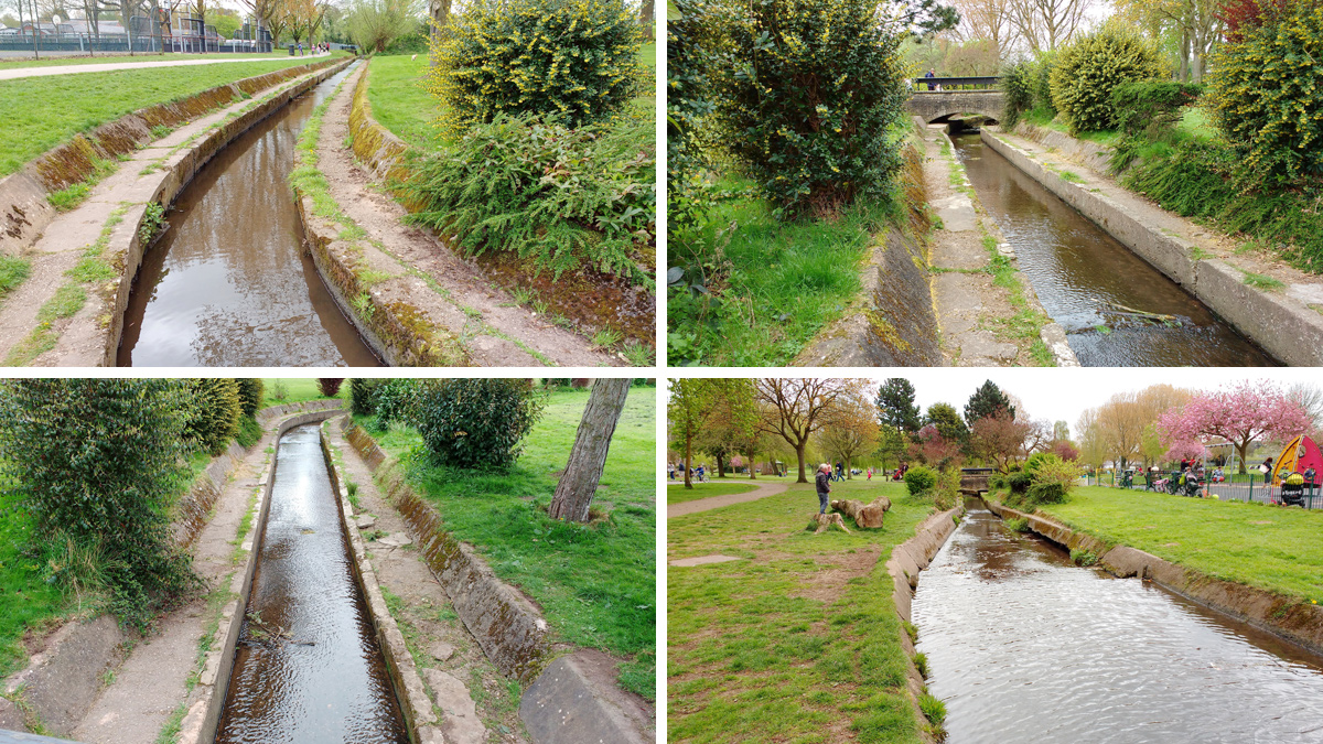
Urbanised concrete lined channel (unsuitable water vole habitat) – Courtesy of Galliford Try
Recommended solution: project benefits
Following a site visit and consultation with stakeholders including Bromsgrove & Redditch District Council, Worcester Wildlife Trust and the Environment Agency the hydro-morphology works were focused on Sanders Park. Whilst there were opportunities for improvements immediately upstream from the park, Worcester Wildlife Trust attempts to promote measures in this reach found landowners unreceptive. The focus on the park provided a more cohesive set of measures that would act as a flagship for the ‘Love Your Bromsgrove River Project’ being led by Worcester Wildlife Trust and for Severn Trent.
The Battlefield Brook through Sanders Park was categorised into 6 reaches and an options long list was developed to identify key opportunities and constraints in each of the 6 reaches. The types of measures considered in each of the reaches were drawn from 4 standard types, taking into account existing function and constraints:
- Do nothing.
- In-channel measures along existing alignment.
- Marginal measures along existing alignment.
- Full channel realignment.
An overview of the proposed scheme was presented to the Environment Agency in early December 2015 and was discussed at a workshop with the Environment Agency, Bromsgrove & Redditch District Council and Worcester Wildlife Trust in March 2016. Stakeholder consultation was very challenging on the project with priorities differing between stakeholders and consultees.
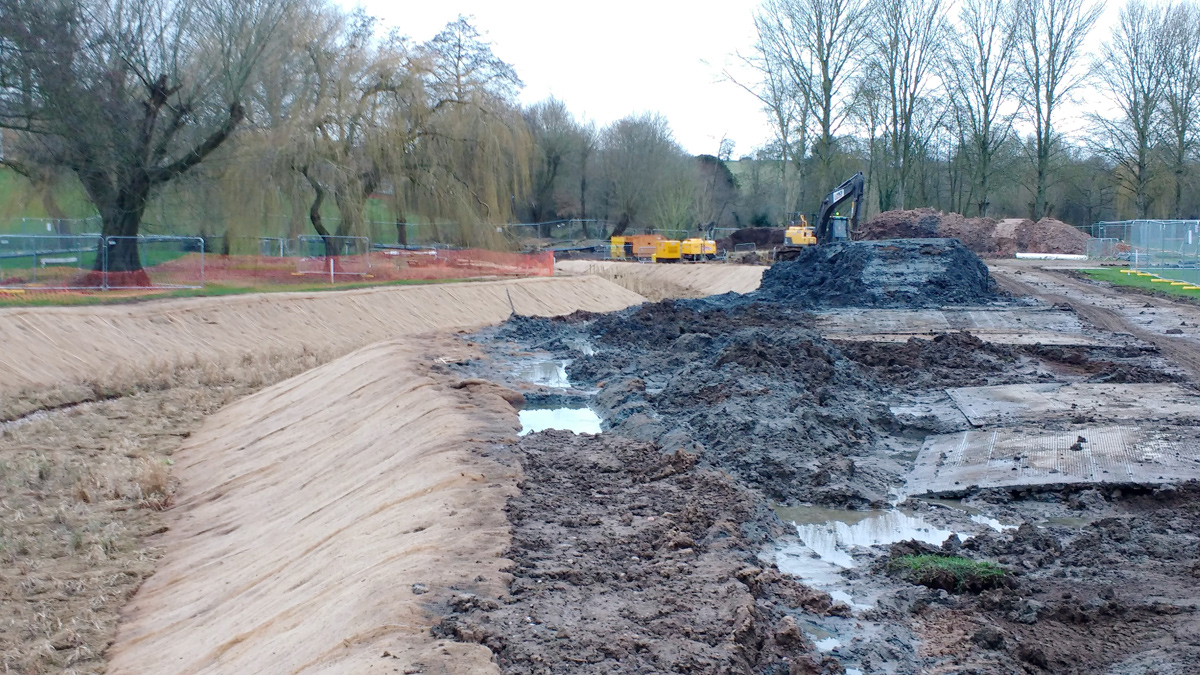
Offline invasive brook construction – Courtesy of Galliford Try
A final design was agreed to construct a new naturalized channel offline with the use of an impermeable geotextile liner and sufficient imported puddle clay to allow water voles to burrow into. This would also include riffles and weir pools. Part of the original straight sectioned concrete channel was retained and tied into the new brook to provide additional storm capacity.
Battlefield Brook Fish Passage: Supply chain/key participants
- Principal designer/contractor: Galliford Try
- Subcontract design (Phase 1): Royal HaskoningDHV
- Subcontract design (Phase 2): Wildfowl & Wetlands Consulting
- Tree works subcontract: Midland Forestry
- Supply coir rolls, faggots & plants: Salix River and Wetland Services
- Supply plants & trees (Phase 2): Green Mile Trees
- Temporary works trench support: VP PLC Groundforce Shorco
- Hire of over pumping equipment: Hydrainer Pump Hire
- Tarmac reinstatement: CR MacDonald
- Supply of clay liner: SIG Construction Accessories
- Supply of puddle clay: SGD
- Bridge edge protection: Galliford Try
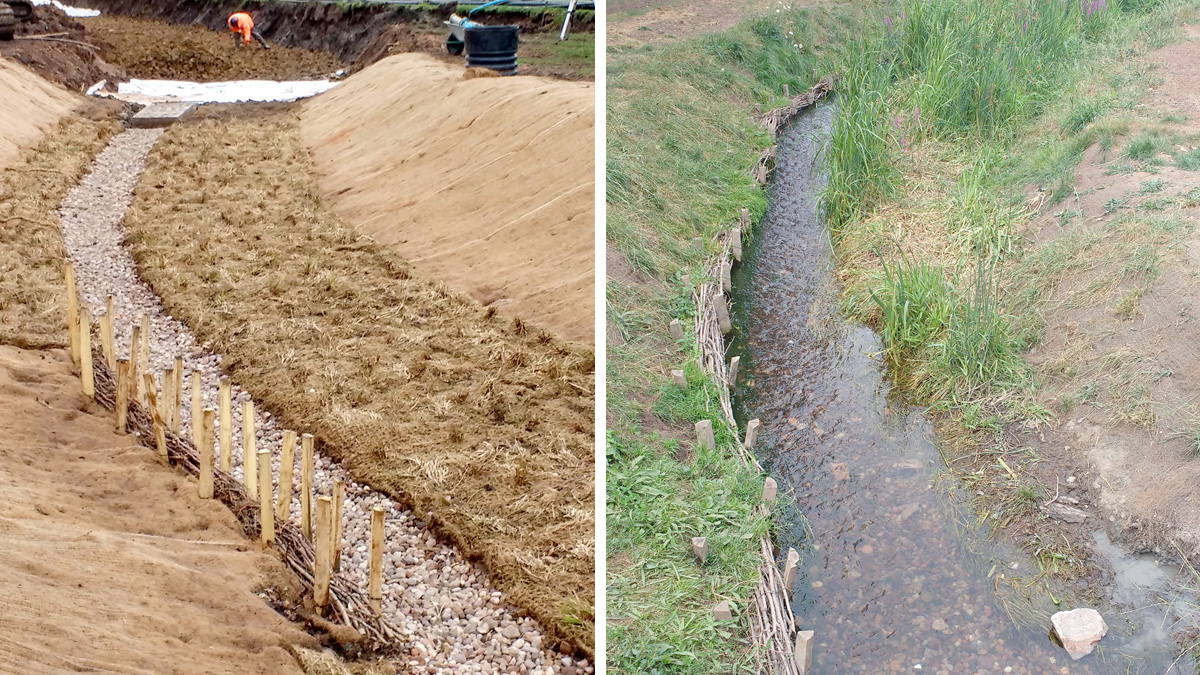
Brushwood faggots at low flow channel – Courtesy of Galliford Try
Investigation and surveys provided by the client
Limited historical information was available from installation of piezometers in Sanders Park by ESI Consulting on behalf of Severn Trent. The data presented was shallow drilling records collected during the installation of groundwater level monitoring piezometers installed at seven locations adjacent to the Battlefield Brook in Sanders Park.
- Topographical & underground services surveys: A topographical and underground survey was commissioned by Galliford Try, this included service searches undertaken within the boundary of Sanders Park.
- Traffic impact assessment: Galliford Try developed and implemented a traffic management plan to maintain safe access for the wider community, park users, and park maintainers. This included timing of deliveries outside of school drop off and pick up times, marshalling vehicles through the park and hard segregation of construction activities from park users and their pets.
- Habitat surveys: Desktop and site walkover habitat survey data was commissioned, this included relevant species and ecological community data available for the watercourse and an assessment of protected species status. eDNA sampling for great crested newts was undertaken.
- Flood risk assessments: A Flood Risk Assessment was produced by BWB Consulting in June 2009 for Bromsgrove District Council in respect of a planning application for improvement works proposed to be undertaken on the heavily canalised and degraded Battlefield Brook. Environment Agency flood maps identify land adjacent to the watercourse in Sanders Park within Flood Zone 2 (land assessed as having between a 1 in 100 and 1 in 1,000 annual probability of river flooding (1%-0.1%) and Flood Zone 3 (land assessed as having a 1 in 100 or greater annual probability of river flooding (>1%)). An updated Flood Risk Assessment was commissioned by Galliford Try, the brook modifications were designed to have a neutral impact on the flood risk.
- Environmental impact assessment/screening: The Land & Planning agent for Severn Trent carried out a formal EIA Screening Request (under Part 2 of the Town and Country Planning (Environmental Impact Assessment) (EIA) Regulations 2011) for the restoration of Battlefield Brook through Sanders Park.
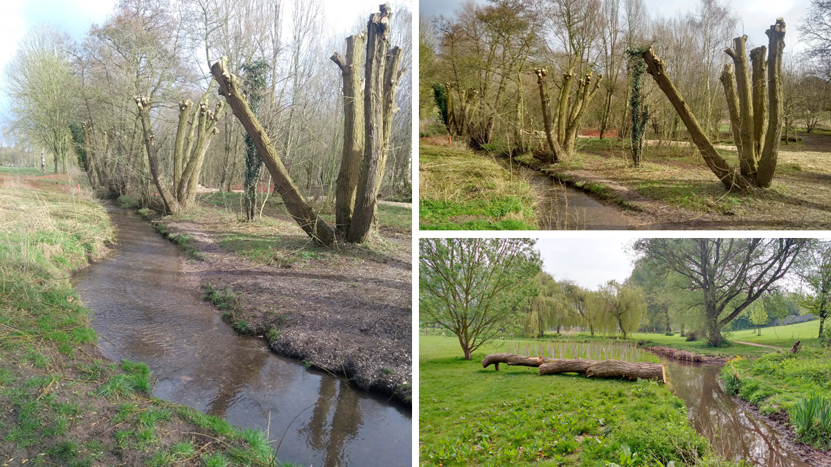
Felled tree trunk and planting to divert desire lines away from the brook edges – Courtesy of Galliford Try
Constraints
The project Risk Plan identified a number of constraints key constraints. These included the need to adhere to protected species legislation and advice relating to water voles. In addition, the park is in constant public use and Bromsgrove & Redditch District Council needed any works to take into account periods of particularly busy use such as school holidays, special events, and public health & safety to remain paramount.
Project phasing
The project works needed to be carried out over a minimum of two years to minimise disturbance to water voles in accordance with water vole strategy timing constraints. A twelve-month period was required between completion of constructing the new channel in Phase 1, and further habitat modifications including tree works, and works in the existing channel local to the existing water vole location, in Phase 2. Phase 2 had to be timed to coincide with the permitted water vole forced migration period (if forced migration was required). Challenges included:
- Ground conditions proved challenging during construction of the offline channel with several areas having a substandard sub-base. Weather conditions delayed the programme being ‘snowed off’ for several days during the winter.
- Reinstatement of unchartered land drains proved a larger task than anticipated.
- The use of ‘track matting’ for commuting between the central site establishment and each working area was at a high financial burden to Galliford Try but offset the disruption and potential long-term scarring of the park.
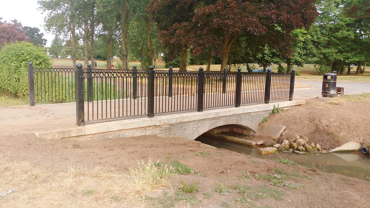
Bridge modifications improving access for park maintenance vehicles, plant & equipment – Courtesy of Galliford Try
At the request of the Bromsgrove & Redditch District Council the project included widening of the main bridge crossing the brook within the park, this was accommodated by Galliford Try and the design incorporated matching the aesthetics of the bridge with other existing bridges within the park.
Conclusion
The scope of Phase 2 was a true collaborative success between Galliford Try, Bromsgrove & Redditch District Council and the Environment Agency by minimising the works in the locality of known water vole locations and mitigating the requirement for forced migration that would have added risks to the water vole population.
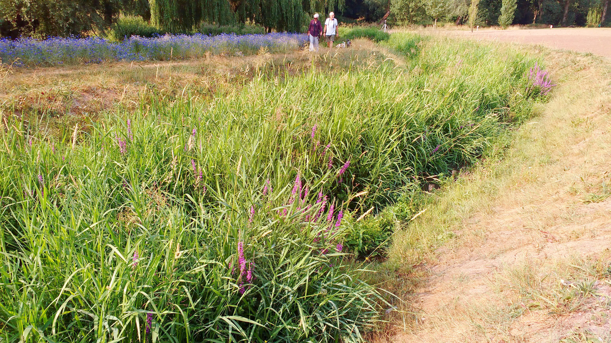
An established section of the brooks new channel – Courtesy of Galliford Try
Erosion protection to the edges of the brook by installing pre-planted coir rolls and staked brushwood faggots, coppicing mature trees and lifting trees to provide additional light to the brook, planting of shrubs and trees to divert natural ‘desire lines’ away from the edges of the brook now provide improved habitat for water voles.
Feedback from park users was very positive, that they loved the new natural look of the brook. Many park users were intrigued and commented that they honoured to have the protected water vole population on their doorstep.


