Killingworth & Longbenton Water Management (2018)

Visualisation of the new ampitheatre style attenuation basin at Longbenton Community College - Courtesy of Esh Stantec
Since 2010, the Risk Management Authorities (RMAs) for the Tyneside drainage catchment have developed and implemented an area-based prioritisation process to identify and investigate those drainage areas at greatest risk of performance failure. The Killingworth, Longbenton and Forest Hall area was one of those areas identified, something supported by the published 2010 Strategic Flood Risk Assessment which identified Longbenton as having the highest risk of flooding. The integrated nature of the drainage system means that it is not practical to assign responsibility for managing the flood risk to a single RMA. The RMAs therefore agreed to the joint delivery of an integrated drainage study to fully understand the issues, opportunities and benefits associated with a collaborative approach to risk management in the area. The study concluded that a collaborative approach could deliver significant benefits to both the residents and the environment, particularly in the area of flood risk reduction to 3,594 properties.
History of flooding and background
The catchment contains over 20,000 properties. Based on a detailed Integrated Catchment Model (ICM) 3,594 properties are considered to be at risk of flooding, which is supported by historic evidence. Over 500 properties have been formally recorded as being affected by flooding.
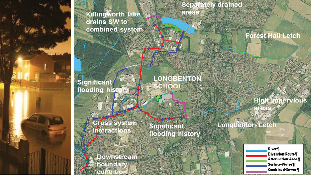
(left) Flooding on Goathland Avenue, Longbenton, 1 July 2007 and (right) Schematic of system and location of SuDS features – Courtesy of Esh Stantec
As flooding has historically been subject to under-reporting, this is considered an underestimation of what has actually occurred. Northumbrian Water Group (NWG) has carried out previous works in the area to address property flooding associated with sewer incapacity. North Tyneside Council (NTC) schemes have included the creation of attenuation areas and bunds on fields in Forest Hall. The developed areas of the catchment are a mixture of domestic housing, retail businesses, schools, industrial estates and business parks with associated infrastructure.
Northumbrian Water (NWG), The Environment Agency (EA) and the local authority North Tyneside Council (NTC) entered into a partnership agreement to work together to tackle flooding. This partnership and a collaborative approach allowed the organisations to share funding, jointly procure design and construction services and work together to find a solution that would benefit all partners.
By working in a partnership this allowed the sharing of wider knowledge which resulted in a greater understanding of the problem and the development of a solution that would provide greater benefits all round.
A sustainable approach to the flooding was agreed by all the partners as the way forward. A sustainable approach would provide the most suitable solution as well as providing great benefits to the whole community in the form of:
- A more innovative solution rather than a solution based on conventional drainage systems.
- Added value opportunities such as increased amenities in the area, enhanced biodiversity and ecology, as well as educational opportunities for the community.
- Engagement opportunities with the community leading to greater support for the scheme and understanding of what the partners were trying to achieve.
The solution
The solution comprised SuDS measures being delivered at multiple sites in a phased approach to manage surface water.
- Phase 1 works were within Longbenton Community College, Benton Dene School and Benton Cemetery and involved the diversion of designated main river and the provision of storage.
- Phase 2 works were upstream on Forest Hall Letch at Killingworth Moor and involved the provision of storage to facilitate receiving the diverted main river.
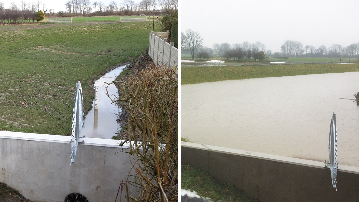
(left) The attenuation area at Killingworth Moor in nearly dry conditions with the flow in the narrow letch channel and (right) attenuation area in operation during March 2018. The levels in Forest Hall Letch are raised and the attenuation area fills as the surface water flows are being managed – Courtesy of Esh MWH
The first and second phase, funded by NWG, NTC, the EA’s Flood Defence Grant in Aid (FDGiA) and local levy, delivered surface water management measures designed with a level of service and betterment on a 1 in 100-year storm. The SuDS components used included attenuation basins, a surface water pond and surface water separation.
Until April 2018, Longbenton Letch, a designated main river, flowed into the combined water system. This scheme involved the removal of this watercourse from the combined sewer system by diverting it to Forest Hall Letch also a designated main river. This involved the construction under Phase 1 of the scheme, of a new 1200mm diameter precast concrete culvert to convey flows from the Letch via the modified existing inlet structure within Benton Cemetery to a new outfall structure at Forest Hall Letch within Longbenton Community College.
In order to receive the incoming watercourse, Phase 2 of the scheme involved construction of three attenuation basins with bunds upstream of the new outfall on Forest Hall Letch within Killingworth Moor, providing a total storage volume of 5000m3.
Each attenuation basin has a flow control to regulate the pass forward flow, and a weir to maintain the top water level and protect nearby properties, with an orifice through the weir to control the flows. In normal conditions the watercourse will flow as normal through the orifice within the precast concrete weir wall and the basins will remain dry.
When flows increase during a storm event, the basins will start to fill to store the excess water within the bunded basin. By holding the flows back in the storage areas upstream of the new outfall within Longbenton Community College, this allows flows to enter from Longbenton Letch. The flows at the final basin are controlled to 0.412m3/s.
In addition to the three attenuation areas there is a further attenuation basin providing 6000m3 of storage capacity within Longbenton Community College constructed as part of the Phase 1 works. This attenuation has been provided near the confluence to slow down the flow in the watercourse.
This attenuation area fills via a weir on Forest Hall Letch and a flow control has been provided to regulate the pass forward flow to 0.7m3/s in the form of a DN375 pipe within a bunded area at a crossing point over the letch.
At the time of the construction of Phase 1, Longbenton Community College was also in the process of constructing a new school building and as part of our community engagement we put forward the proposal of constructing a pond and wetland area to receive surface water from the school roof instead of the planned underground storage tank.
As such a new pond with wetland area and boardwalk was constructed for the school offering educational opportunities, increased amenity area and biodiversity at a reduced cost.
The attenuation basin within the school was constructed in the form of an amphitheatre at the request of the school so it could be used as an amenity area for games such as rounders. The basin will remain dry for the majority of the time so it can be used by the school and will only fill during storm conditions when the excess flow is stored until the storm recedes and the basin slowly empties at a controlled rate (approximately 14 hours to empty when full) through a ductile iron outlet pipe of DN200, back into the letch.
The basin has a natural appearance and is grassed to blend in with the school field with sloping stepped sides to provide the amphitheatre. The sides slope at a maximum gradient of 1 in 3 to allow the grass to be maintained and mowed and to allow easy access and egress from the basin.
Using SuDS over conventional drainage systems on the scheme reduces the carbon footprint as less concrete is used, less raw materials are used and the costs are also reduced.
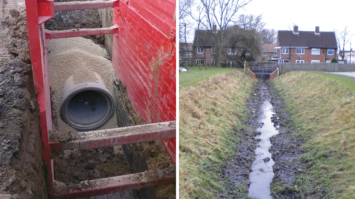
(left) New DN1200 culvert under construction and (right) Longbenton Letch in Benton Cemetery discharging to the NWG system – Courtesy of Esh Stantec
Design approach
The design was undertaken by Esh MWH as a joint venture and with an approach aimed at applying the latest best practice for surface water management schemes, which required a wider design team with a range of different skills. A landscape architect was used to develop a natural look for the basins and to develop a planting scheme for the wetland/pond area. An ecologist provided advice on planting and tree removal to facilitate the scheme. 3D visualisations were prepared by a specialist graphics team.
The study used an integrated model which included a representation of the existing sewerage system, surface water drainage system, watercourses and runoff from fields and greenspace within the catchment. The model quantified flood risk at the catchment properties which was required to obtain FDGiA funding.
The model was verified against flow surveys undertaken across the sewer network with rain gauges and flow monitors being installed. A flood risk assessment was undertaken using the MWH flood risk tool.
Civil 3D was used throughout the scheme to develop the solution and visualisations were created using the 3D model with a landscaping tool so they could be used for customer events which were held at various stages to involve the community in the scheme.
Construction approach
The design was undertaken by Esh MWH as a joint venture under an NEC Option C contract. The construction was phased with the Phase 1 works within Longbenton Community College, Benton Dene School and Benton Cemetery being constructed first. Construction commenced in summer 2016 to coincide with the school summer holidays, with a construction period of 7 months, followed by the Phase 2 works at Killingworth Moor which commenced in April 2017; with a construction period of 4 months.
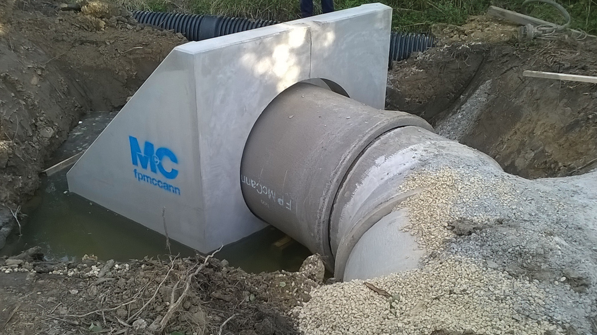
Outfall from new DN1200 culvert under construction at Forest Hall Letch – Courtesy of Esh Stantec
The works consisted predominantly of earthworks which were constructed using 3D GPS with work undertaken by sub-contractor, Groundwork Services. The ground conditions comprised clay soils which eliminated the need of the basins to require lining. The bunds were constructed from clay soils excavated from the site. Civil 3D was used to calculate the cut and fill required and spoil from the excavations was reused to level the existing school playing fields and bunds which minimised the amount of spoil taken off site.
The planting, landscaping and reinstatements were undertaken by specialist sub-contractor Marley’s who are experienced in this area.
The works were located at multiple sites and involved working in a secondary and primary school, a community village green, Benton Cemetery and Killingworth Moor. Due to the nature of their use the areas were very sensitive and the contractor worked to minimise disruption and to keep the public informed.
- The works in Benton Dene School and Longbenton Community College were programmed to start in the summer holidays to avoid disruption.
- Early engagement with the school personnel was critical in achieving a good outcome. This allowed the schools to put forward their concerns and their preferences which could then be incorporated into the design.
- A public meeting was held for the community to voice their concerns allowing them to be addressed early in the design process.
- Notices explaining the works were posted.
- Individual measures were put in place for vulnerable customers identified early on in the scheme.
SuDS approach
This scheme has maximised the opportunity to use soft engineering techniques with multiple benefits to reduce costs, saving £4.2 million over a more traditional solution using underground storage tanks. The solution does not require mechanical or electrical systems and uses gravity therefore saving energy and reducing operational costs.
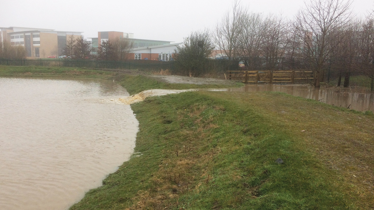
The attenuation basin at Longbenton Community College in operation during March 2018. The levels in Forest Hall Letch re-raised and the basin is filling as the flows from the letch spill over the weir – Courtesy of Esh Stantec
SuDS offer wider benefits than traditional techniques as they can also improve water quality, provide new habitats, enhance biodiversity, create community spaces and provide educational facilities and benefits.
At Longbenton Community College which was being developed as part of the Priority School Building Programme, the flooding scheme was brought forward so it could be programmed to align with the school development. The SuDS approach resulted in a new amphitheatre for games, a new wetland pond and viewing platform to be used for educational purposes and up-graded playing fields.
At Longbenton Village Green where the new culvert was constructed, the green was reinstated with wetland scrapes being provided, raised and accessible planters, solar lighting, orchard and wildflower planting providing the local community with a much-improved amenity.
At Killingworth Moor part of the area is proposed for housing development and the SuDs areas provided at this site will form part of a future amenity area for the community. Early engagement with the developer for this land has resulted in sharing proposals for future land use, in order to achieve the best outcome for the community.
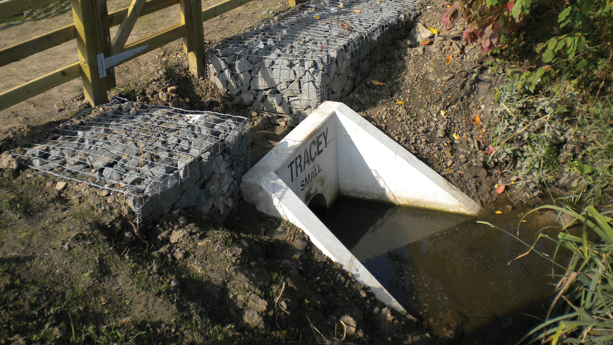
The flow control structure at Forest Hall letch within Longbenton Community College – Courtesy of Esh Stantec
Partnership approach
Funding from all the flood risk authorities including NWG, the EA and NTC has been brought together to cover the £5.2 million cost of the project ensuring that a scheme that was unaffordable and undeliverable by any single party has been successfully implemented. This has ensured that public and private funding has been brought together to ensure best value for flood risk authorities and their customers. This approach is proving to be an economically viable model and ensures maximum value for the wider community.
The maintenance of the new assets has been carefully considered as part of the options appraisal and is shared between the Risk Management Authorities. The CIRIA BEST Tool, which estimates the impacts of SuDS, was used to calculate and monetise the environmental benefits of the scheme and demonstrated over £30m of benefits to include amenity value, biodiversity and ecology, flooding, recreation and education, with the reduction in flood risk generating the majority of this value.
The scheme has been funded with resources from NWG’s asset management plan, the EA’s Grant in Aid funding and NTC’s Flood Resilience Programme. NWG’s AMP6 programme runs until March 2020 and has been aligned with the EA’s 5-year partnership programme.
The partnership delivered a more suitable and sustainable solution, providing a greater level of protection to properties, wider benefits to the community and a lower overall cost than could be achieved by any individual organisation.
Community engagement
Early customer and community engagement was crucial to the success of the project. A customer liaison team was engaged to manage customer concerns. The project team engaged very early on and held extensive consultations with the schools affected by the works, community groups, the local history group, landowners, English Nature and the Tyne Rivers Trust as well as the wider community. This allowed for joint working and a scheme resulting in all round benefits for everyone.
The scheme was well supported by the local community and this continued throughout the construction phase which resulted in a smoother construction period and a positive response from the community.
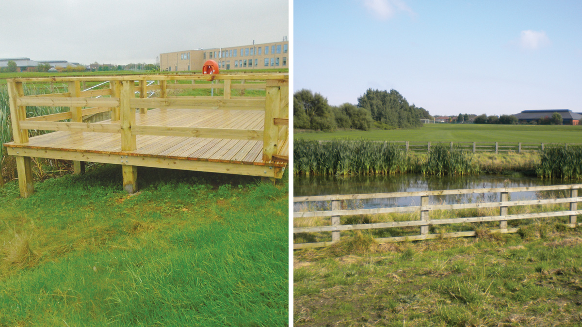
(left) Viewing platform over wetland pond for educational purposes at Longbenton Communtiy College and (right) the wetland pond draining surface water from Longbenton Community College – Courtesy of Esh Stantec
Summary and conclusion
Construction was completed within programme and budget. Following the completion of the works at Killingworth Moor the flows were turned at Benton Cemetery bringing the scheme into operation in March 2018. The scheme has performed well since and monitoring is ongoing.
There will be significant environmental improvements following implementation of the scheme including less sewage spill into the main rivers via combined sewer overflows of up to 81,000m3 annually. By freeing up capacity in the sewage network the scheme has also enabled new development to go ahead resulting in economic growth and prosperity for the Killingworth and Longbenton area of North Tyneside.
By working in partnership, the team delivered a more suitable and sustainable solution with a greater level of flood protection to properties and wider benefits to the community than could be achieved as individual organisations.
Early community engagement proved successful in securing support for the scheme with wider benefits to be enjoyed by all. This project has also been successful at recent industry awards including the RICS NE 2018 Award for Infrastructure. The next phase of this scheme is planned to start on site in the summer of 2018 and will involve works at Killingworth Lake and the transfer of flows to West Moor Tributary.


