
Southampton & Andover Link Mains (2025)
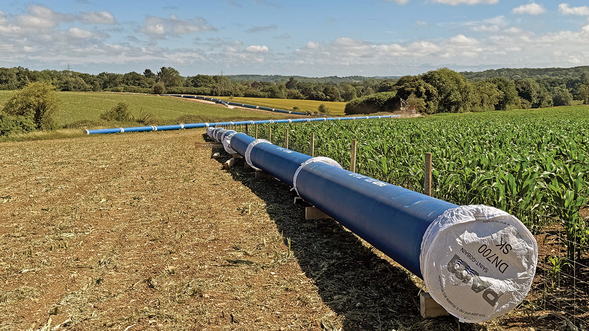
Otterbourne to Yew Hill DN700 pipework - Courtesy of Bartlett Contractors Ltd
The Southampton and Andover Link Main Schemes (SLM/ALM) are being delivered by Southern Water Services (SWS) under the Water for Life Hampshire (WFLH) programme. The WFLH programme aims to create greater resilience to water shortages, especially during dry weather and droughts. Existing abstraction licences for the River Test and River Itchen have been significantly reduced by the Environment Agency to protect these rare and sensitive rivers. Both are designated as Sites of Special Scientific Interest (SSSI), and the River Itchen as a Special Area of Conservation (SAC). With more than 85% of the world’s chalk streams in the UK, these rivers are key examples of rare chalk stream habitat which support a wide variety of species. The proposed schemes, alongside the development of new sources of supply such as water recycling, will secure resilient water supplies for customers while helping reduce abstraction from these rivers, especially during a drought; so there is more water left in the environment when nature needs it most.
Background
The Water Resources Management Plan 2019 (WRMP19), and subsequently updated for WRMP24, sets out Southern Water’s response to the water supply challenge in Hampshire. The response consists of a strategic new source of supply, new and increased bulk supplies from neighbouring water companies, demand management, and new strategic transfer pipelines across the region. SWS were required to identify the optimal infrastructure and associated operational controls required to transfer the new supply from Otterbourne Water Supply Works (WSW) to the’ existing distribution networks supplied from Testwood WSW (Southampton) and River Way WSW (Andover).
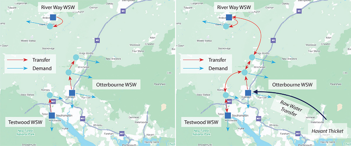
Optimisation model components: (left) the current network and (right) the proposed new network – Courtesy of Southern Water
The Southampton and Andover Link Main Schemes are potable water transfer schemes which are required to link up key SWS operational sites across Hampshire to ensure continued sustainable, reliable water supplies.
Principally, the proposed schemes consist collectively of approximately 41km of new trunk mains ranging in size from DN500-DN900, operating in conjunction with a number of existing strategic trunk mains, connecting key WSW’s and Water Service Reservoirs (WSR) across a number of Water Resource Zones (WRZ). Additionally, the schemes include new pumping and storage assets to support the water transfers.
Solution optimisation
Through the scheme optioneering phase, which started in early 2022, a Network Control and Optimisation (NCO) study was undertaken to align with and build on previous work undertaken in WRMP and other strategic network modelling studies.
The aim of the NCO study was to assess the resilience of the proposed new strategic transfer pipelines, often referred to as the Western or Hampshire Grid, and how different options might exhibit varying levels of resilience across business as usual (BAU) and drought operation. The study was completed with the understanding that the infrastructure architecture could not be determined unless the associated operation was also defined. The study was conducted in parallel to engineering design development to determine the preferred options for design, construction and commissioning as part of the wider Water for Life Hampshire programme, ensuring a holistic approach across the region.
The study utilised a proprietary AI software product, Optimizer, to develop optimal asset configurations and was chosen to reduce program costs and expenditures. A traditional approach would typically involve hydraulic models using an iterative “trial and error” method, but the large number of options would make it impossible to evaluate all possible outcomes.
Using Optimizer, with which the Southern Water InfoWorks network model was linked as an embedded hydraulic engine, enabled the automatic evaluation of thousands of trial solutions computing cost and performance, and incorporating operating constraints and design criteria. Optimizer produces a range of least-cost network solutions, including asset sizes and maximising the efficiency of network operational performance, considering both BAU and drought supply/demand scenarios.
The tool produces a set of plans along a Pareto front that represents the optimal-performing configuration for a budget cost, and therefore quickly identifies options to be analysed in further detail. This process enabled efficient development of the engineering design as the scheme architecture was refined quickly with focus on key assets required.
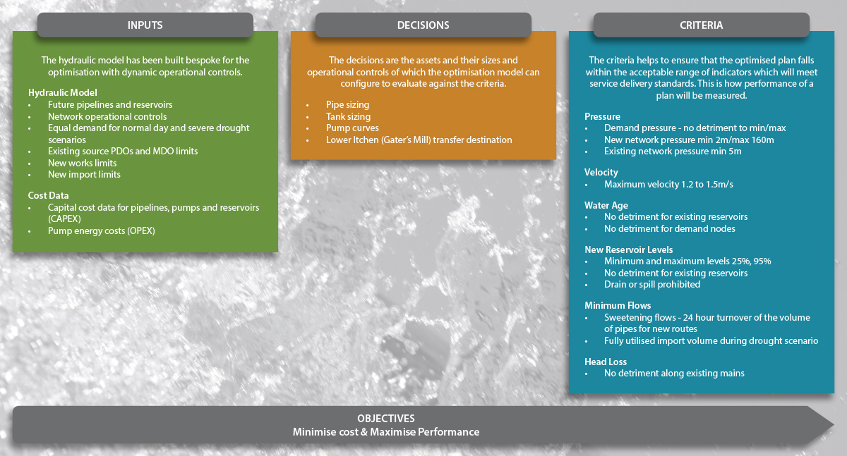
Optimisation model components – Courtesy of Southern Water
Scheme development
Through 2022 as the scheme transitioned into concept design, various route corridor options were considered between the fixed strategic sites identified within Otterbourne, Southampton and Andover.
Options considered additional alternative Southern Water operational sites to interconnect with and how to transfer water between these sites to provide further system resilience. These options were refined initially through careful review of desktop environmental, ecological and heritage constraints information, later supplemented by data obtained through site visits, and field surveys (non-intrusive and intrusive).
Options considered the location of the pipeline easement, access routes, pipeline materials and construction methodology. A key intermediate site selected to integrate into the system was Yew Hill WSR, located to the south-west of Winchester. This provided opportunity to utilise common sections of pipeline transfer from Otterbourne to serve SLM and ALM whilst maximising existing transfer capability. This also provided opportunity to expand potable water storage capacity in a network location capable of providing numerous resilience options.
From the initial assessments, high level route corridors were established and broken down into a series of segments. The segments were then appraised in detail following a Red, Amber, Green (RAG) classification by environmental, ecological, heritage, engineering and construction specialists.
Different route options were demonstrated with different segments, with some segments having sub options within. Through a desk-based process, each discipline provided their feedback on the key constraints within each segment, and where mitigation could be required and the form it could take.
Where there were options between or within segments, a preference was stated by each discipline with clear factual reasoning. From these preferences, the route was selected depending on which constraints for each segment were most critical to avoid, whilst balancing constructability and land access constraints.

Pipeline route refinement methodology – Courtesy of Southern Water
Following internal SWS project delivery process, agreement on a single option to progress to outline design was made based on a combination of technical, operational and environmental considerations.
The general design and construction principles used to develop the initial pipeline route of the schemes were to minimise:
- Number of major road crossings.
- Number of bends along the route.
- Overall length of the pipeline.
- Encroachment into urban or built-up areas.
- Interaction with other existing utilities.
- Requirement for works within flood zones.
- Requirement for vegetation removal.
- Works within areas of unsuitable ground quality such as historic landfill.
- Works within areas with poor ground conditions such as peat and alluvium.
- Interaction with environmentally sensitive areas.
The proposed pipeline routes and design were subsequently further refined taking into account environmental constraints identified through field surveys, archaeological investigation, community considerations and engineering capabilities clarified through intrusive ground investigation.
All desktop and survey data was made available to all project disciplines via the utilisation of Mott Macdonald’s Moata digital platform, specifically Moata Geospatial and Moata Land Management. This provided all teams withs access to information at every stage of the project, allowing cross-disciplinary teams to collaborate in real time.
The integration of the Moata platform was so successful that it won Best Project – Innovation at the Institution of Civil Engineers South East England Engineering Excellence Awards in 2025.
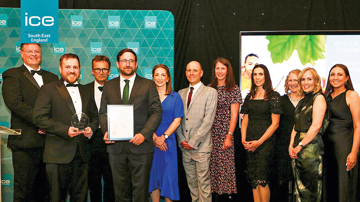
Members of the Southern Water and Mott MacDonald teams at ICE awards – Courtesy of Institution of Civil Engineers
Southampton Link Main: Proposed scheme scope
The key components selected to form the scope for the SLM are as follows:
- Extension to existing the Otterbourne WSW High Lift Pump Station (HLPS): Includes additional pumps each fitted with 315kW motors.
- New pipeline between Otterbourne WSW & Yew Hill WSR: A DN700 ductile iron pipeline, approximately 4.3km in length, of which approximately 0.5km requires DN1500 micro-tunnelling across three pipe-jacks.
- Rownhams WSR: New inlets to the existing service reservoir and flow control valve arrangement.
- New pipeline between Yew Hill WSR & Rownhams WSR: A DN900 ductile iron pipeline, approximately 14.6km in length, of which approximately 1.35km requires DN1500 micro-tunnelling across five pipe-jacks.
- Yew Hill Service Reservoir: A new 8.5Ml service reservoir at Yew Hill cross connected to the existing WSR and associated pipework.
- Testwood WSW: Pipework cross connections.
The scheme will provide a transfer between Hampshire Southampton East WRZ and Hampshire Winchester WRZ and a transfer between Hampshire Winchester WRZ and Hampshire Southampton West WRZ. Specifically, the scheme will transfer water from Otterbourne WSW to Yew Hill WSR and onward to Rownhams WSR and Testwood WSW.
Key design constraints for the scheme included:
- The need for long pipe-jack drives to negotiate a congested alignment between Otterbourne WSW and the M3.
- New WSR at Yew Hill to expand storage capacity, integrating multiple existing and new supply feeds whilst maximising efficiency of design to operate in numerous flow scenarios.
- The need for a trenchless crossing of the Chandlers Ford to Romsey railway line.
- Mitigating impact (direct or indirect) to Emer Bog SAC through careful route optimisation.
- Modified control of existing pipelines and operational sites to reverse flows.
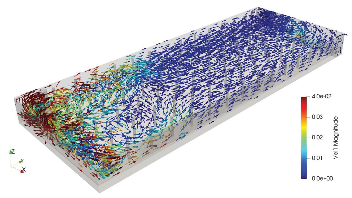
Yew Hill WSR CFD 3D model : Velocity vector plot – Courtesy of WRc via MGjv
Andover Link Main: Proposed scheme scope
The key components selected to form the scope for the ALM are as follows (NB: At the time of writing (July 2025) scheme refinements are ongoing and some of the following may be subject to change):
- Olivers Battery Water Booster Station: Upgrades to the mechanical, electrical, instrumentation, control and automation (MEICA) works at the existing booster station.
- Micheldever Road WSR: New inlets to the existing service reservoir and flow control valve arrangement.
- New pipeline between Crab Wood WSR & Micheldever Road WSR: A new DN500 pipeline (diameter and pipe material TBC), approximately 22km in length.
- New network WBS within Andover: Duty and location TBC.
The scheme will provide a transfer between Hampshire Winchester Water Resource Zones and Hampshire Andover Water Resource Zones, specifically the scheme will transfer water from Yew Hill WSR to Crab Wood WSR and onward to Micheldever Road WSR and the Andover distribution network.
Key design constraints for the scheme included:
- Extensive archaeological mitigation requirements.
- Interaction with Ministry of Defence operational land.
- Trenchless crossings of River Dever SSSI and River Test SSSI.
- Multiple crossings of the A303 including utilisation of trenchless installation.
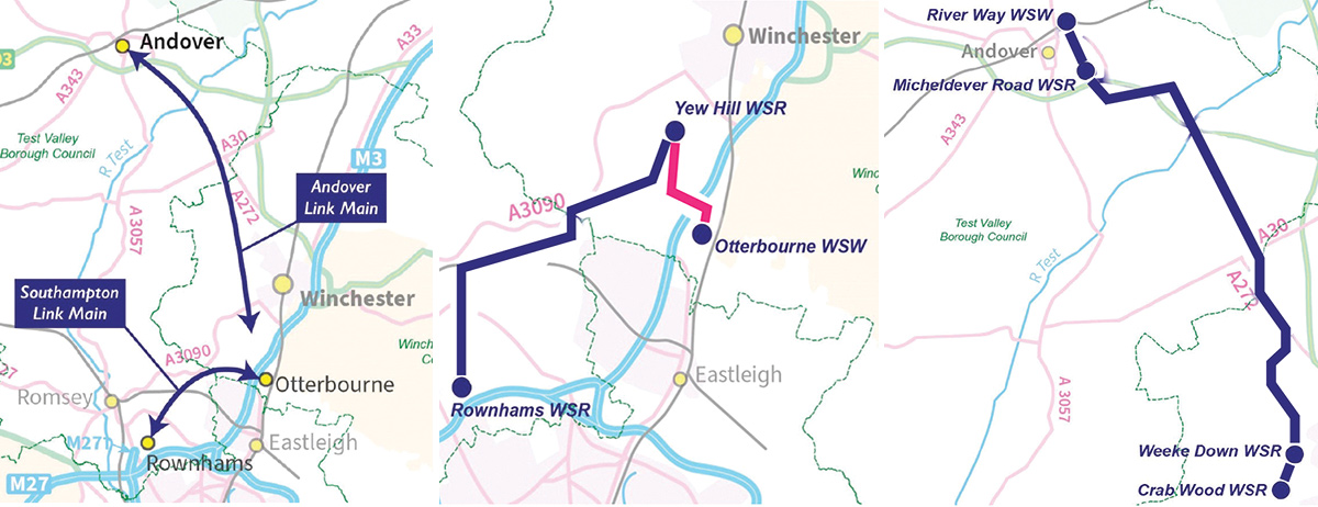
(left) SLM & ALM location plan, (middle) SLM alignment overview and (right) ALM alignment overview – Courtesy of Southern Water
Site investigations and scheme consenting
In 2022, MGjv was appointed as Principal Contractor and Principal Designer to undertake Early Contractor Engagement (ECE) support across both schemes; assisting with development of the concept design. As scheme development moved into 2023, MGjv coordinated and undertook extensive site investigation works to verify ground conditions. The scope of the investigation comprised trial pitting, cable percussion boreholes, rotary core boreholes, downhole geophysical testing, surface geophysical surveying, laboratory testing and the preparation of factual reporting.
In parallel, numerous excavations at different locations along the two proposed pipeline routes were undertaken to explore the potential for buried archaeological remains. Initially, an extensive programme of archaeological trial trenching was completed which informed the requirement for subsequent selected strip, map and sample works.
In late 2023, Southern Water submitted requests for EIA Screening Opinions on each scheme to the Local Planning Authorities to confirm requirements for planning consent. Final responses were received in Spring 2024. The outcome of the requests was that SLM was not deemed EIA Development and therefore retained Permitted Development (PD) Rights where applicable. In comparison, ALM was deemed EIA Development and requires a full Planning Application and Environmental Statement (ES) to be submitted for approval.
A summary of site investigation works is as follows (as of early 2024):
- Southampton Link Main
- 41 geotechnical pits excavated.
- 9 sample boreholes undertaken.
- 313 archaeological trial trenches dug.
- 122 geoarchaeological trial trenches dug.
- 3,100m2 strip, map and sample (as of early 2024).
- Andover Link Main
- 128 geotechnical pits excavated.
- 29 sample boreholes undertaken.
- 317 archaeological trial trenches dug.
- 65 geoarchaeological trial trenches dug.
- 31,219m2 strip, map and sample (as of early 2024).
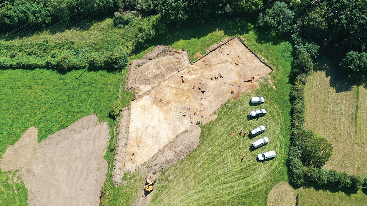
Archaeological strip map and sample investigation – Courtesy of Southern Water
Undertakings
Following confirmation of the planning requirements for both schemes in Spring 2024, MGjv was contracted to deliver the full design and delivery of the SLM as the scheme was able to progress under PD Rights for the pipeline. Separate discrete assessments were undertaken that clarified the new Yew Hill WSR, which was also confirmed as PD. The expansion of the Otterbourne WSW HLPS would be subject to a planning application.
The requirement on the ALM scheme for full planning and ES required additional design and survey/investigation works to be undertaken and so MGjv has continued in an ECE role until mid-2025 to support the application, due late 2025. The procurement strategy for the full design and delivery is currently being developed.
SLM & ALM: Supply chain – key participants
- Client: Southern Water
- Principal designer/contractor: MGjv
- Galliford Try
- Morrison Utilities
- Tunnel design: Arup
- Tunnel design: HB Tunnelling Ltd
- Tunnel design: Joseph Gallagher Ltd
- Service reservoir design & CFD modelling: COWI
- Service reservoir design & CFD modelling: WRc
- SLM open cut pipelaying works : Bartlett Contractors Ltd
- Moata GIS: Mott Macdonald
- Ecology surveys: Kingfisher Ecology
- Archaeology surveys: Wessex Archaeology Ltd
- Pipes: Saint Gobain PAM UK
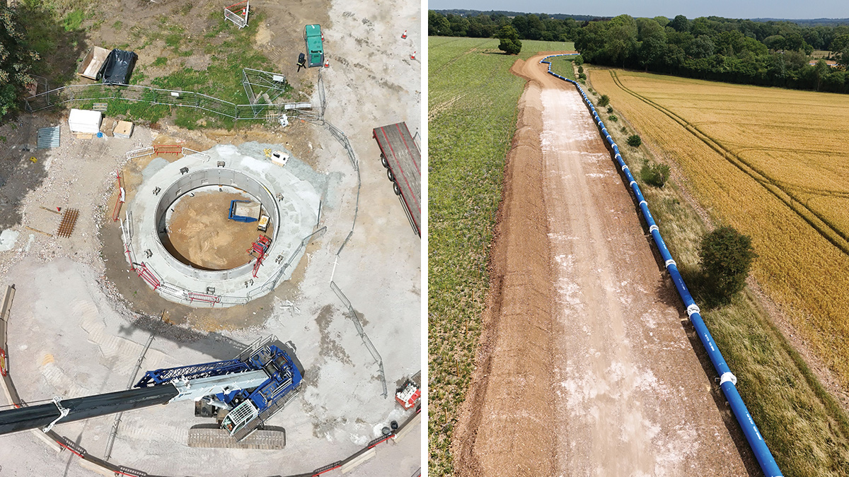
Otterbourne to Yew Hill: (left) shaft sinking – Courtesy of Southern Water and (right) DN700 pipework – Courtesy of Bartlett Contractors Ltd
Summary & next steps
The Southampton and Andover Link Main Schemes will provide a new strategic supply backbone across Hampshire to maintain security of supply to customers and help protect the county’s rare and sensitive chalk streams.
The schemes will provide additional BAU resilience whilst also providing capability to mitigate important drought restrictions being placed on the River Test and River Itchen, impacting key operational sites within the region.
Further articles will follow in due course covering the detail design, construction and commissioning phases of the schemes.