Gouthwaite Impounding Reservoir (2018)
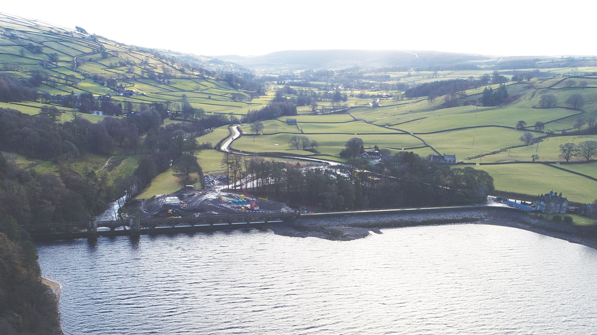
Figure 1: View upstream of Gouthwaite IRE - Courtesy of MMB
Built under the Bradford Corporation Waterworks Act 1890, Gouthwaite Impounding Reservoir (IRE) forms the lowest of a cascade of three reservoirs in Upper Nidderdale, all designed by their chief waterworks engineer. The upper two reservoirs, Angram and Scar House, supply water along the Nidd Aqueduct to Bradford. Gouthwaite IRE was built 11km downstream to provide riparian compensation to the River Nidd. To comply with the Reservoirs Act 1975, the improvement works at Gouthwaite IRE were required to bring this excellent example of Victorian engineering in line with modern safety standards. Yorkshire Water Services (YWS) contracted Mott MacDonald Bentley Ltd (MMB) to undertake the design and construction of the new reinforced concrete (RC) overflow channel to improve the safety of the dam.
Introduction
Gouthwaite is impounded behind a composite dam, constructed between 1893 and 1901, comprising a masonry faced, cyclopean concrete, gravity dam to the left-hand side (LHS) of the valley and an earth-fill dam to the right-hand side (RHS). The maximum depth of water retained by the dam is 13m. The reservoir capacity is 7.11Mm3 with a surface area of 134 hectares at the top water level of 135.76m LD.
Gouthwaite Reservoir has the largest dammed catchment in Yorkshire totalling 115km2; approximately 1% of the area of the county. Given the catchment size, the flows the channel is required to withstand are greater than any other spillway in the region. The probable maximum flood (PMF) conditions, for Gouthwaite was modelled at around 920m3/s; equivalent to the daily peak flow of the River Tyne.
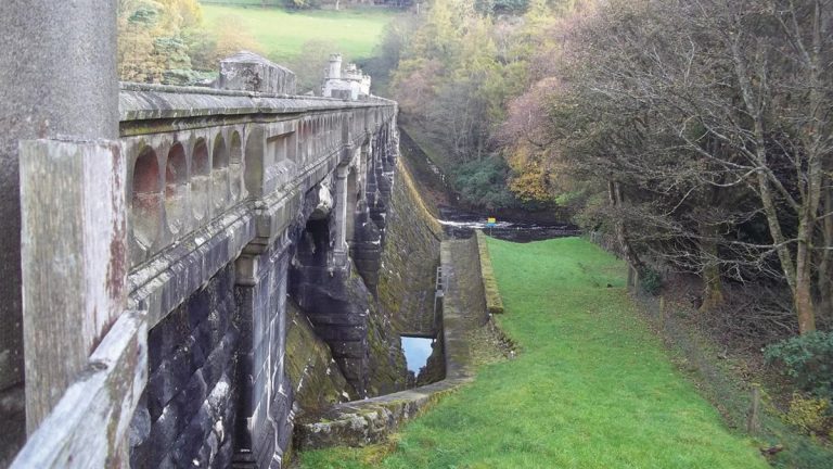
Figure 2: Original overflow channel – Courtesy of MMB
Investigation optioneering
The multi-arched bridge that runs the length of the 170m long gravity dam section carries a 3m wide crest road. The overflow is an integral part of this section and is formed by the downstream face of the gravity section of the dam, including the outer collection channels. The arch spans form the fourteen overflow weirs, 4 (No.) primary bays with a weir level of 135.76m LD, and 10 (No.) outer secondary bays with the spill weirs set 300mm higher at 136.06m LD. All of the weirs are 9.10m in length, providing a 127.40m total weir length.
The weir arrangement is not symmetrical with the primary weirs at bays 8-11, such that flow passes directly down to the stilling basin at the toe of the dam, 14.5m below weir level. Flood flows over the outer bays, 1-7 on the RHS and 12-14 on the LHS, are collected by masonry channels that pass along the dam mitres and discharge into the stilling basin.
A 1:35 scale model of the masonry gravity dam section, shown in figure 3, was used to evaluate the performance of the existing overflow arrangement. The performance of this weir arrangement was proven to be satisfactory up to the PMF flow; however, the model identified the principal risk to the dam structure was the capacity of the RHS overflow collection channel, where out of channel flow presented a risk of erosion of the RHS earth mitre.
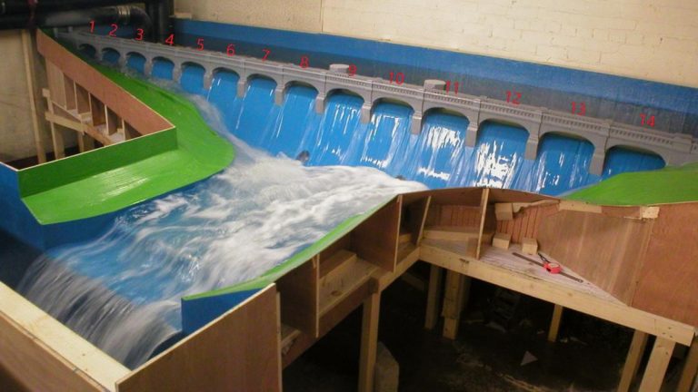
Figure 3: Physical model of original channel (1:35 scale) – Courtesy of MMB
In view of the findings from the initial scale model tests, an optioneering exercise identified seven initial solutions with the potential to address the hydraulic capacity deficit.
The aim of the solution development was to either reduce the flow that the existing channel would be required to contain by re-routing flows, or to increase the capacity of the channel.
In collaboration with YWS and the qualified civil engineer (QCE), these options were consolidated by way of a high-level risk-based approach, considering the technical, construction, cost, programme, operational and maintenance risks, as well as the capability to meet the business risk. The consolidation of the initial solutions provided three outline solutions that were further evaluated by scale model and site investigation and included:
- Option 1B: Lowering the 4 (No.) primary weirs and fitting moveable weirs, allowing the outer RHS weirs to be blocked.
- Option 4A1: Increasing the capacity of the RHS collection channel to fully contain and route the PMF flow.
- Option 7: Increase the capacity of the RHS collection channel to route a 1 in 500-year flow, with erosion protection to ground surface behind the channel.
Site investigation was used to confirm the composition and scale of the gravity dam structure. The investigation found that the extents of the mass concrete structure were far in excess than previously thought. This concluded that the risk to the stability of the gravity dam structure resulting from erosion of the RHS mitre was less significant than previously understood. Consequently, the design requirement was refined to a containment of a 1 in 1000-year event.
Detailed design: Solution refinement
The delivery of this project has been undertaken through an integrated delivery model where the client, consultant and contractor are in the same collaborative service team. This team is challenged to deliver the scheme together in the interests of all parties. This close-knit system has been instrumental for project success and overcome numerous challenges and constraints.
Having reviewed the proposed notional solution with the multi-disciplinary project team, it was identified that there was an opportunity to further refine the invert level of the new channel. By raising the invert, the benefits included:
- Reduced excavation depth reducing programme and cost.
- Removed the risk of the masonry face being destabilised through removing its support.
- Defined tie in point for the new invert slab.
- Potential for improved hydraulic performance of the channel.
To achieve the proposed efficiency, assurances that the hydraulic performance and capacity of the channel still met the design criteria were needed. It was decided to utilise MMB’s in-house computational fluid dynamics (CFD) team to assist with optioneering. The team initially compared and calibrated their model to the physical model results, before modelling the new channel geometry.
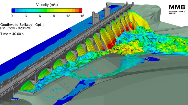
Figure 4: CFD at PMF (above 1000-year design case) – Courtesy of MMB
The orientation of the channel wall, being perpendicular to the flow cascading down the down-stream face, creates a slightly unusual spillway wall load condition. In this load case, a dynamic force needs to be considered alongside the hydrostatic force within the channel. An initial structural assessment was completed by taking the maximum bed velocity and converting this into a worst case load using the conservation of momentum. This was an onerous and unrealistic load case, as there was no reduction due to the flow passing perpendicular to the wall.
Subsequently, the CFD model was utilised to provide accurate hydrodynamic and hydrostatic load conditions for the wall. Due to the height of the wall, it was designed as a T-shaped retaining wall to withstand the large lateral loads generated in both the channel full, and channel empty load conditions.
The spillway has been geometrically designed to contain the required flows while aesthetically tying in with the main dam structure with a masonry style. A form-lined finish was applied to the concrete to tie in with the Victorian construction. A quality finish can be difficult to achieve on large wall pour, but this is made more challenging with the form-liner which can entrap air.
The construction team completed a trial panel to ensure the required quality for a water retaining structure could be met, adopting a robust inspection and testing plan, including concrete pour checklists, to guarantee the quality was achieved. By utilising this inspection and testing procedure which included traditional pokering and external shutter vibrators, a quality finish which required minimal rubbing up was achieved.
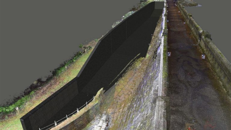
Figure 5: Navisworks overflow channel – Courtesy of MMB
The design had been conducted to produce a sympathetic structure and allow flexibility in construction. Due to the coursing of the existing masonry, the construction team proposed a saw cut to provide a uniform joint with the new RC base slab.
Despite this, the bays were not a uniform shape and therefore the reinforcement was detailed in-house to ensure maximum flexibility on site to account for any variation in the joint location. The starter bars were extended above head height to remove the risk of puncture injuries and avoid the need for placing temporary protection to the vertical bars.
The attention to detail has been excellent. For example, the spillway wall was topped with surplus coping stones from another recently-rebuilt channel. The copings were re-cut and faced by hand on site to fit in with their surroundings.
To help the design and construction, the project team utilised an integrated process of laser scanning to produce accurate models of the dam and surroundings, tying this into the complex physical and CFD hydraulic models, and inputting this directly into the project’s 4D model. This was used in several ways.
Firstly, given the size of the catchment there was a real challenge to be able to achieve the required draw down to provide sufficient flood protection. By showcasing the 4D modelling to the client, MMB demonstrated the logic behind the programme and provided assurance that it was the most efficient sequence. The 72-week construction programme was reduced by 18 weeks.
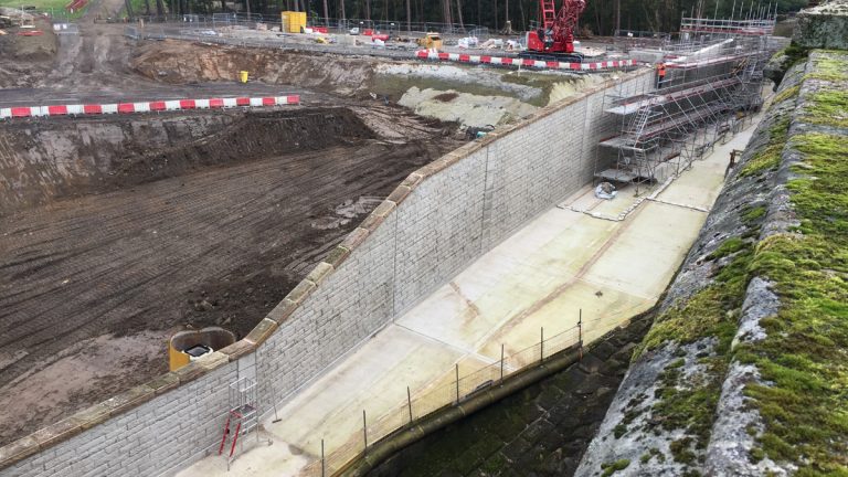
Figure 6: Overflow channel coping reinstatement – Courtesy of MMB
The project has seen over 46,000 hours worked, over 600 safety interventions reported, and a ratio of 1 hour of behavioural safety discussions for every 200 hours worked on site. To date there have been no formal third-party complaints; this can be attributed to the project team closely engaging with and managing all identified stakeholders.
The works have been under scrutiny by a wide range of these stakeholders, the most prominent of which include the Environment Agency, a Reservoir Management Board as dictated under the 1890 Act of Parliament Harrogate Borough Council, local angling clubs, a flooding campaign group in the town of Knaresborough (established following the Boxing Day 2015 floods), local parish councils, the local MP, and many more. The success of delivering this project required delicate and attentive third-party management by MMB and YWS from the very commencement of the scheme.


