
Hedges Farm River Restoration Project (2020)
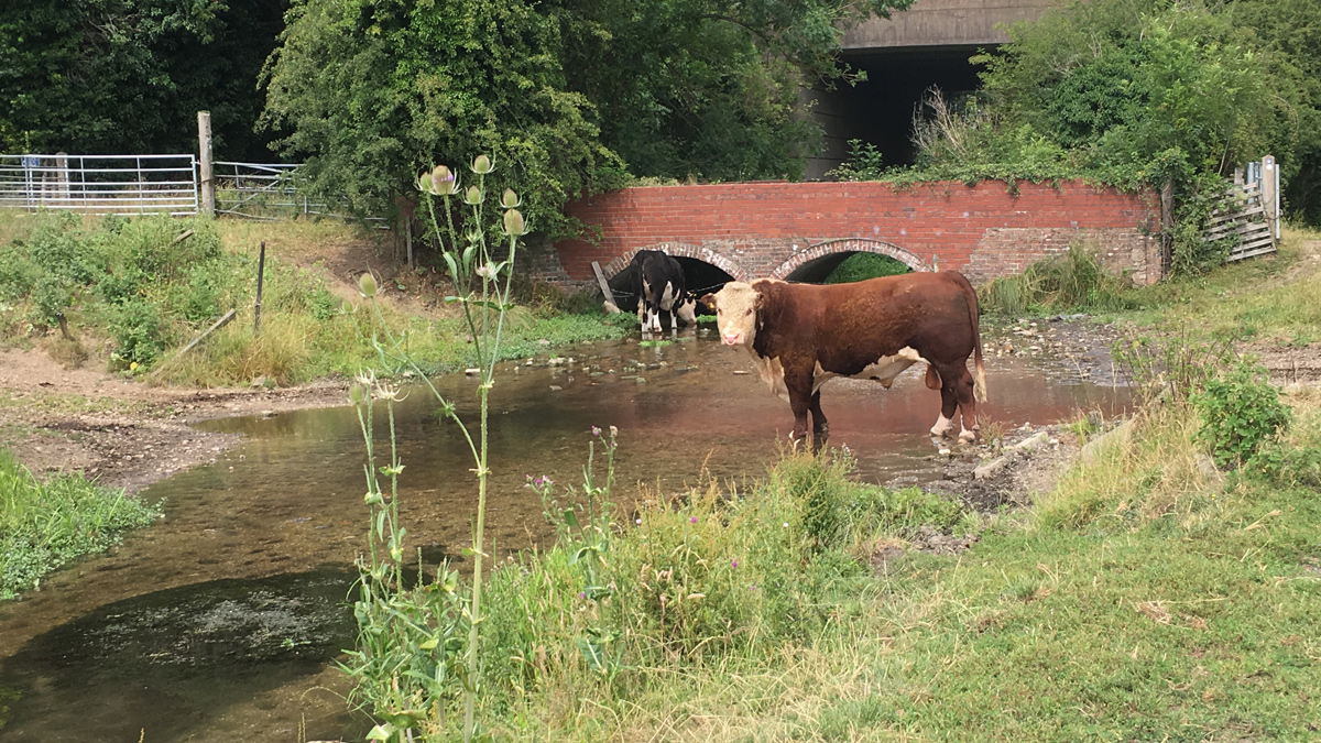
Hedges Farm before the river restoration project. The cattle had uncontrolled access to the River Ver which resulted in poaching of the banks and bed - Courtesy of Affinity Water
The River Ver is a chalk river tributary of the River Colne in Hertfordshire. Chalk rivers are a globally rare habitat, with around 240 existing worldwide. There are approximately 160 chalk streams in England with 10% located within the supply area of Affinity Water. The Environment Agency placed targets (through the Water Industry National Environment Programme) for Affinity Water to contribute to improve the EU Water Framework Directive (WFD) classification of the Rivers Ver, Gade, Misbourne, Mimram, Beane and Lea that run through the home counties, to support Good Ecological Status/Potential (GES/P) by 2027. The Hedges Farm project is one of a number of projects that has taken place as part of the Revitalising Chalk Rivers Collaborative Partnership. The partnership aims to restore and improve the habitat and resilience of chalk streams in Affinity Water’s supply area.
River Ver at Hedges Farm
Hedges Farm is located on the outskirts of St Albans in Hertfordshire, between London Colney and Park Street. The River Ver through Hedges Farm was historically diverted from its original route into a mill channel which is perched above the valley bottom. The river has been straightened, widened and historically dredged which has resulted in unnatural chalk stream morphology with minimal flow diversity. The surrounding fields are grazed by cattle and as a result the banks have been poached and damaged (Figure 1). This has caused bank destabilisation and erosion with the resulting fine sediments entering the river. An excess of these sediments in the river has a negative impact on the characteristic chalk stream gravel bed by covering the gravels that brown trout use as spawning habitat.
Stakeholder engagement
The project began when Affinity Water approached the landowner and tenant in 2015 to discuss a river restoration project. The original suggestion was to move the river back to its original route in the valley bottom, joining up with the downstream watercress beds. However, the landowner and tenant were not supportive of this option. There were further constraints around re-alignment of the river channel for a number of reasons including: the land being approved for a new rail freight terminal and country park, the river flowing under the A414 dual carriageway and embankment, a large trunk sewer that runs adjacent to the river and a high pressure oil pipeline that also runs through the site. This would have made any river re-alignment extremely challenging regardless of the landowner and tenant objection.
In 2017, the landowner and tenant were approached again with a revised river restoration project plan which included in-channel river improvements. This received support from the landowner and tenant, and this was agreed with the Environment Agency as a suitable alternative scheme to the original realignment option.
With approval from the landowner to go ahead with this river restoration, the upcoming project was presented at a local river group open meeting in October 2018. The proposal received general support from stakeholders who could see the benefits to the river and positive feedback was also received from attendees of the indicative visualisations (Figures 2 to 4).
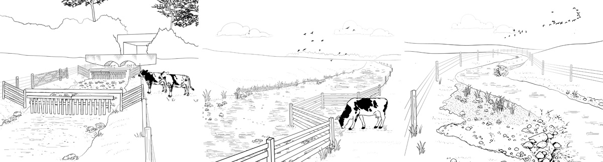
(left) Figure 2: Indicative drawing of the proposed cattle crossing points (middle) Figure 3: Indicative drawing of the proposed cattle drinking points, and (right) Figure 4: Indicative drawing of meandering river within its existing channel due to the installation of in-channel berms – Courtesy of Affinity Water
Following the development of the outline designs, draft detailed designs were presented at a local river group open meeting in July 2019 where again only positive feedback was received. The final detailed designs were shared with all stakeholders in August 2019 when Affinity Water applied for an environmental permit application. This was approved before the 8-week determination period allowing construction to start on site at Hedges Farm in September 2019.
Design and construction
The stakeholder engagement ran smoothly due to the excellent design and indicative drawings. The team were able to use these to really promote the benefits of the project to all stakeholders. The design philosophy underpinning the development of the river restoration measures at Hedges Farm was to reproduce natural fluvial processes. This approach aimed to ensure a self-sustaining river system that requires minimal future long-term management.
Hedges Farm River Restoration Project Supply Chain
- Designed the river restoration project: cbec eco engineering
- Construction of the river restoration project: Salix River and Wetland Services
- Tree works and ecological surveys: Maydencroft
- Water vole surveys: M&H Ecology
The design (produced by cbec eco engineering) and construction (undertaken by Salix River and Wetland Services) comprised of channel narrowing to increase flow diversity using a series of in channel berms to create a more sinuous channel planform within the confines of the existing channel. In some areas this involved formalising berms which had naturally started to develop during low flow conditions. By working with natural geomorphic processes in this way, by formalising naturally developing berms, it ensured a sustainable and long-term habitat improvement.
When designing the in-channel berms, empirical geomorphic theory was used. This dictates that pool-riffle spacing within natural channels is 5 to 7 times the channel width. Where the channel was narrower a pool spacing of the between 45m to 65m was implemented. Where the channel increased in width a spacing of 60m to 85m was used. The exact length and spacing between the berms varied along the length of the river restoration reach to increase natural variability within the channel, as would be expected within an unmodified channel. The berm structures were designed to be located in areas where hydraulic modelling had shown higher in-channel velocity values to ensure the greatest impact on the physical processes and the associated ecological benefit.
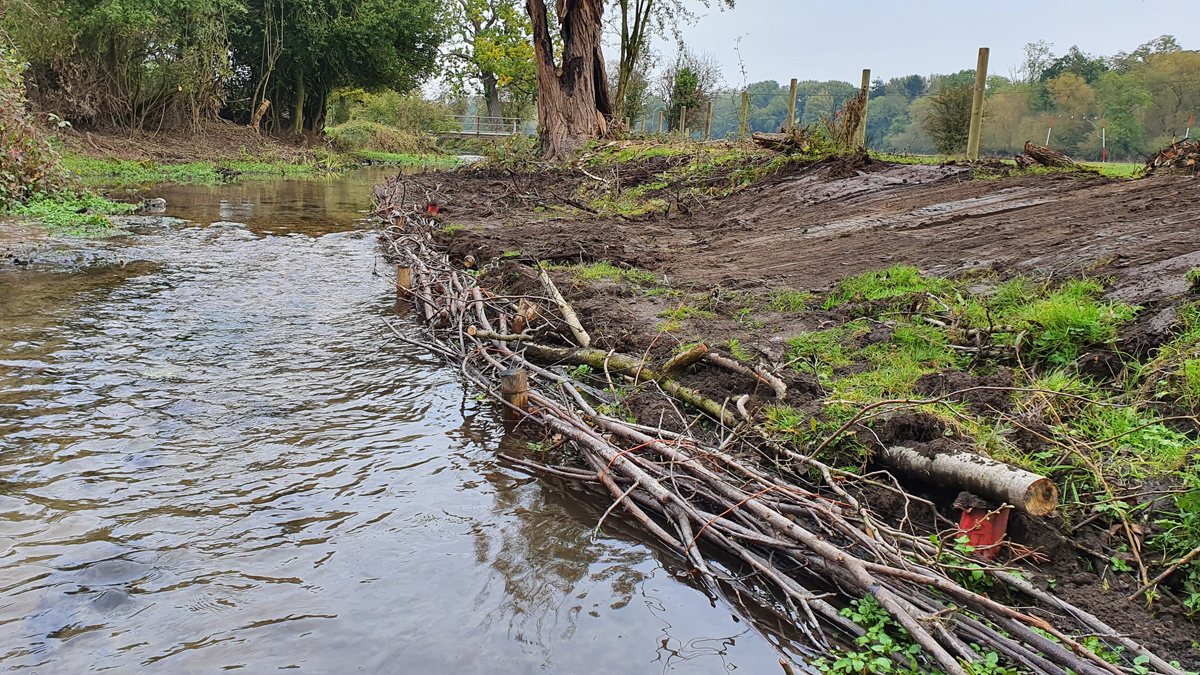
Figure 5: Constructed in-channel berm with hazel fascines lining the front of the structure – Courtesy of Affinity Water
The in-channel berms were constructed in a traditional way being built around hazel fascines back-filled with gravels, brash and fine sediment (Figure 5). The hazel fascines were pegged down with wooden stakes driven in place and positioned in such a way as to create a ‘D-shaped’ geometry. The berms were then plug planted with native species to encourage the establishment of vegetation and longer-term stability of the structures. Following the installation of the in-channel berms, a small volume of imported gravels (8 mm to 32 mm) were placed within the channel to aid the improvement of the bed profile of the river channel. The addition of gravels has improved the long profile of the reach by creating localised changes in bed elevation, resulting in riffle and pool features throughout the channel.
To prevent cattle poaching the riverbanks and to reduce the amount of fine sediment entering the river, stock fencing was incorporated into the design along the entire 1.4km stretch of river throughout the site (Figure 6). There was a difference of opinion on the positioning of the fence line; some stakeholders wanted it along the top of the riverbank and others wanted it installed 8m from the top of the bank. The positioning of 3m from the top of the bank was agreed on site with all stakeholders once the construction process had started.
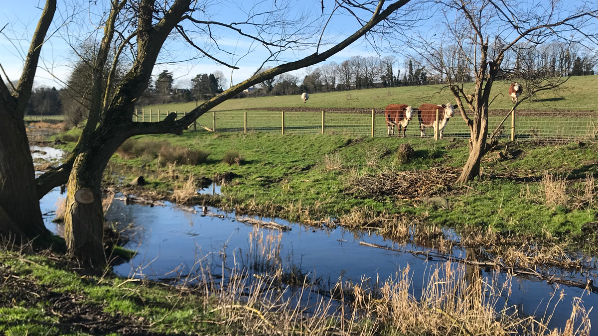
Figure 6: Photo of the new fencing installed 3m from the top of bank, doing the job of stopping the cattle accessing the river outside of the crossing and drinking points – Courtesy of Affinity Water
Cattle crossing point
To prevent cattle from damaging the riverbed and to allow access to alternative grazing areas, five cattle crossing points were designed and constructed (Figure 7). The cattle crossing points were located perpendicular to the channel and constructed to be approximately 4m long (longitudinal channel length). An armoured channel bed was created which extended up the immediate channel banks (entrance and exit ramps). The material used to create the armoured bed is a mix of large gravels (32 mm to 64 mm) and small cobbles (64 mm to 92 mm). This gravel size means the material is unlikely to be entrained during higher magnitude flow events, increasing the long-term stability of the crossing points. At the upstream and downstream extent of the crossing, a water gate was installed to stop cattle walking down the channel. The water gates include a series of wooden droppers located laterally across the channel and not fixed in place ensuring higher magnitude flow events are not impeded.
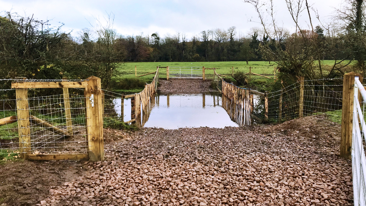
Figure 7: Photo of a cattle crossing point with field gates and water gates – Courtesy of Affinity Water
Cattle drinking points
Two cattle drinking water points were included in the design to ensure the cattle still had access to the river for drinking water (Figure 8). These were designed to utilise areas that the cattle already used and were constructed to be approximately 7m maximum width, tapering to 4m wide (longitudinal channel length) towards the channel edges. The cattle drinking points were fenced off using wooden rail fencing and stout posts which were placed along the wetted channel edge and at upstream and downstream extent of the drinking station. The fencing was positioned so that livestock can access water at low flows but ensured that no fence posts are located within the wetted channel.
An access ramp was created at each drinking station to minimise bank erosion and fine sediment entering the river. To reduce erosion of the channel bank, a mix of large gravels (32 mm to 64 mm) and small cobbles (64 mm to 92 mm) were placed on the access ramp to reduce poaching.
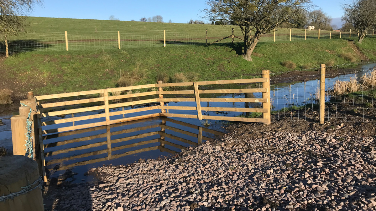
Figure 8: Photo of a cattle drinking point – Courtesy of Affinity Water
Project Timetable
- Outline Design: January 2019 to May 2019
- Detailed Design: May 2019 to August 2019
- Construction: September 2019 to January 2020
Increased site biodiversity
The above measures were designed to combat the lack of flow diversity and cattle poaching along the River Ver at Hedges Farm. The team decided to maximise the biodiversity benefits by incorporating ponds in a fenced off wildlife area within the floodplain to create additional habitat (Figure 9).
The construction of Hedges Farm river restoration project was completed on site in January 2020. We will continue to monitor the site to understand the hydrological and biodiversity response as a result of this river restoration over the coming years.
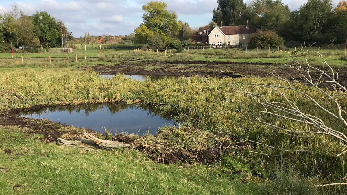
Figure 9: Photo of the ponds created to enhance the sites biodiversity – Courtesy of Affinity Water
About Affinity Water
Affinity Water is the largest water-only supply company in the UK, providing on average 900 million litres of water each day to a population of more than 3.6 million people in parts of Bedfordshire, Berkshire, Buckinghamshire, Essex, Hertfordshire, Surrey, the London Boroughs of Harrow and Hillingdon and parts of the London Boroughs of Barnet, Brent, Ealing and Enfield. We also supply water to the Tendring peninsula in Essex and the Folkestone and Dover areas of Kent. Along with supplying high quality drinking water, Affinity Water have embarked on an ambitious programme to improve the health of rivers within our supply area through a holistic approach to environmental sustainability. Through a combination of catchment management, abstraction reduction and river restoration works, Affinity Water aim to sustain healthy groundwater levels, improve water quality, improve channel morphology, and flows in globally rare chalk streams.
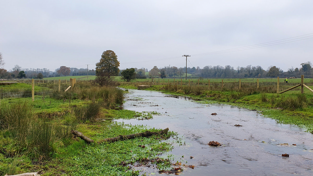
Figure 10: Photo at the top end of the site following the completion of the river restoration project at Hedges Farm – Courtesy of Affinity Water