
Thames Water UPM Scoping Studies (2018)
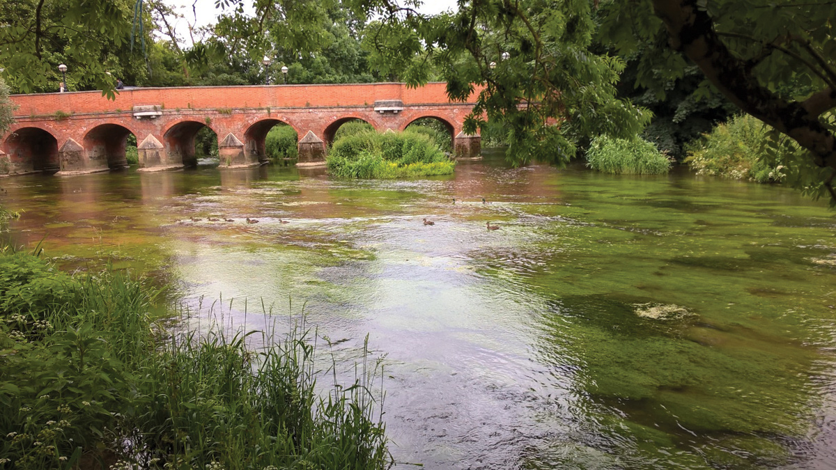
Figure 6: Evidence of algae in the river - Courtesy of Thomson Ecology
The Environment Agency (EA) identified a number of waterbodies which were deemed to be at risk of deterioration or failure to achieve the Water Framework Directive (WFD) ‘good’ status due to the impacts from wet weather discharges from the urban wastewater network. Seventeen of these waterbodies were within the Thames Water region and the risk of failure was as a result of both ecological and physiochemical elements (see Figure 1). The drivers for each of the water bodies included one or more of the following determinants: (i) ammonia, (ii) dissolved oxygen, (iii) phosphate, (iv) fish and (v) macro-invertebrates.
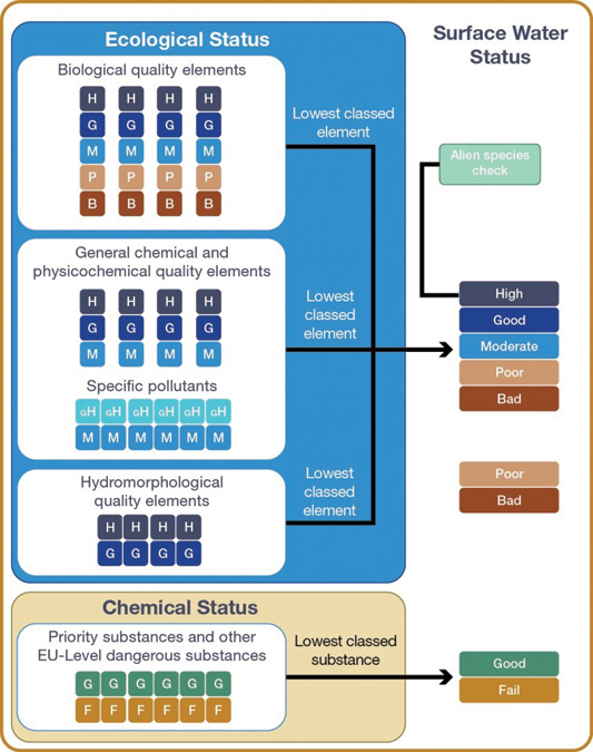
Figure 1: WFD good ecological status classification summary – Courtesy of Stantec UK
Introduction
eight2O was commissioned to carry out detailed scoping studies on each of the 17 waterbodies within the Thames Water area to determine potential impact from their assets on receiving water quality. Depending on the findings, eight2O recommended whether a full Urban Pollution Management (UPM) scoping study would be required in AMP7 and the scope and scale of investigations required.
A total of 320km of watercourse was investigated under the scoping studies, which equates to approximately 6.5% of main watercourse in the entire Thames Water region. This project had a budget of £4.5m and a regulatory delivery date of September 2017. The studies were delivered on time, in just 15 months, and generated savings of approximately 34% through initiatives such as efficient data collection and management and the automation of data retrieval.
The highlighted areas in Figure 2 show the 17 waterbody catchments, ranging from built-up areas of central London, to rural countryside, each bringing their own challenges during the collection of survey data.
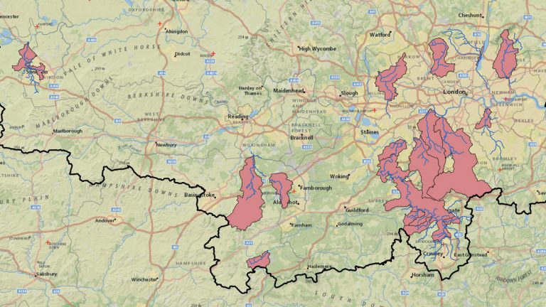
Figure 2: Catchment map (Google Mapping) – Courtesy of Stantec UK using ArcGIS
Investigations
Historical data gathering and gap analysis: eight2O carried out a detailed gap analysis of existing and historical data, from both Thames Water and EA, relating to compliance with WFD standards. This enabled a targeted and intensive programme of surveys to be identified that allowed eight2O to develop a detailed understanding of impacts from Thames Water assets on the waterbodies. The outcome meant an informed decision on the need for a UPM study in AMP7 could be made.
In the case of some of the more urban streams, drivers such as the waterbody’s ability to support fish and macro-invertebrates populations were a challenge to address. In many cases the modifications to the waterbody meant that even if the water quality met the criteria, fish and macro-invertebrates are unlikely to thrive due to elements such as the lack of vegetation in and around the river on culverted sections and physical barriers to fish migration.
River Trusts for some of the water bodies are actively addressing some of these issues; however, the investigations would highlight areas where an improvement in the water quality would be required to ensure thriving populations.
At the outset it was clear that for the programme to be successful the collation of existing data as well as knowledge of the watercourse and its surrounding area would be key.
Thames Water Operatives and local River Trust groups hold valuable knowledge about the interaction of the surrounding area on the waterbody and might already have evidence of the source causing deterioration to the water quality.
To unlock this information, a series of ‘seek to understand’ meetings were held with Thames Water Operatives from both the sewer network and treatment teams, which was used as a forum to share experience, knowledge and data relevant to each of the study catchments. The findings of the local River Trust were also shared amongst the project team.
Data was also gathered from various departments within Thames Water including the Environmental Protection team who shared vital information already collected on known polluted surface water outfalls as well as known misconnected properties within the study areas. All this information helped to build a detailed picture of potential impacts to water quality in the river reach. Regular stakeholder meetings were held with Thames Water, the EA and eight2O project teams for the duration of the project which was crucial to achieving the delivery of the study.
Data collection: The study was heavily focused on wet weather impacts on each of the waterbodies. Therefore, gaining a more frequent view of chemical changes than is available in the EA recorded data was vital. The EA data is collected, on average, once a month and therefore more regular data collection could identify conditions when water quality was shown to deteriorate and confirm if it was wet weather related and the source.
By analysing rain gauge data with recorded sonde data for all the chemical aspects of the river water quality and recorded spill events at overflows, the potential source of pollution could be identified, or ruled out. Impacts from different land uses such as seasonal agricultural activities, air bases and industrial areas were considered, which in turn affect the run off into waterbodies. Understanding each of these issues using the detailed survey data allowed for a recommended catchment-based solution specific to each study area.
Given the time constraints of the project, an integrated approach for both gathering historical and current data was required to ensure all analysis and reporting were complete by the regulatory deadline. To put in perspective, the study required:
- 78 sondes to be installed across the waterbodies for a 16-week period collecting data every 15 minutes.
- Flow monitors needed to be installed at 38 sites to capture overflow data where a permanent Event Duration Monitor was not already installed.
- Water quality sampling at each of the 78 sites was required on a weekly basis to capture phosphorous levels unable to be recorded on the sondes.
All of these surveys needed to be installed and data gathered concurrently. Collaboration between all contractors involved was paramount to achieving the completion of these surveys within a timescale which allowed analysis of the data and reporting of the findings. Figure 3 shows an installed sonde unit.
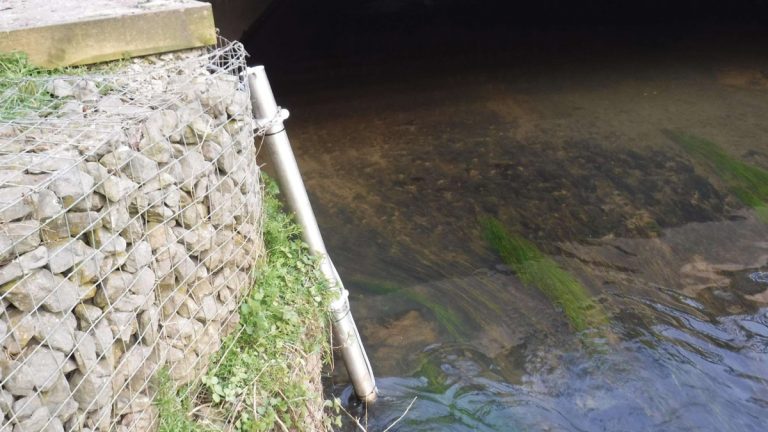
Figure 3: Installation of a sonde unit – Courtesy of IETG
To compliment the data obtained from surveys a range of open source data such as rainfall and river flow data, needed to be gathered for all locations to aid the understanding of the issues along each individual waterbody.
In addition, river walk surveys along all 320km of the investigation area were carried out to identify every discharge into the river reach, whether it was a Thames Water asset or not and a spot sample of ammonia and DO levels in the discharge was recorded using a handheld meter, if there was any flow present. 142 sites were identified for macro-invertebrate and diatom surveys in two seasonal windows across one calendar year. This alone was a huge undertaking and required a large amount of planning to ensure the seasonal windows were met.
Efficient data management: The project team identified a number of solutions to manage the large amount of data being collected and put in place automated data retrieval and ArcGIS applications for the time-series data and spatial data respectively.
For the time series data, the team used a database approach to store the data. This approach enabled the efficient management of 1957 unique data streams and a combined 22,600,000 readings.
840 of these streams, from a range of sources including open sources, SCADA systems and live site monitors, were automatically downloaded, manipulated and stored on a weekly basis using ruby scripting; thus saving hundreds of man hours and reducing the potential of human error in data collection.
For the geospatial data a mobile device was used by all of the contractors with an ArcGIS based application configured with a bespoke set of pro formas for each specific survey, returning data to the project team in one consistent format. The application ensured all survey data was geotagged on site in a format that could be loaded directly into ArcGIS, including imagery.
An automated output of assessment forms and plans was also produced for each individual surveyed asset, creating efficiencies in the post processing of survey data. An additional benefit of collecting data in this way was live feedback from the site team directly to the office if for example a pollution source was identified and required urgent attention.
Thames Water UPM Scoping Studies: Table of Designers, Contractors and Suppliers
- Client: Thames Water
- Alliance delivery partner: eight2O *
- Water quality sonde survey: IETG
- Water quality sonde survey: EMS
- Flow monitor survey & river walk survey: RPS
- River Walk survey: 40Seven
- Water quality sampling, macroinvertebrate & diatom surveys: Thomson Ecology
- Land Agent: Dalcour Maclaren
* eight2O is the largest alliance in the water sector. The partners involved are Thames Water and two design and build joint ventures made up of: Costain, Atkins, Black & Veatch (CABV) Skanska, MWH (now Stantec UK) and Balfour Beatty (SMB)
Case studies
Lower Roding: The Lower Roding is an urban watercourse and serves a population of approximately 200,000. During the install of the water quality sondes, a pollution incident was observed by the contractor on site see Figure 4. Due to the instant availability of imagery, including orientation, the project team was able to action the findings and report back into the relevant department in Thames Water for urgent attention providing exact location and time stamped evidence of the incident.
In this instance the evidence collected through surveys indicated the observed pollution shown in Figure 4 was not as a result of a Thames Water owned asset.
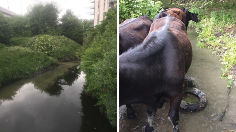
(left) Figure 4: Pollution observed from an outfall in Lower Roding – Courtesy of IETG and (right) livestock with open access to Tanners Brook – Courtesy of 40Seven
Tanners Brook: Tanners Brook is a rural catchment with very few discharges into the watercourse. Thames Water has two intermittent discharges into the river along its 7km length.
Both discharges recorded spill events during the 16-week monitoring period. However, using the chemical data recorded at the sondes and water quality data it was determined that spill events from the two discharges had no significant impact on DO, phosphate or ammonia.
The high phosphorous levels were unlikely to be due to domestic sewage because the ammonia levels recorded were low. However, the poor phytobenthic community and good invertebrate community suggested that phosphates were the primary issue. In this rural river the survey data confirmed that agriculture (see Figure 5), low flows and diffuse pollution are likely the key sources of deterioration in water quality and therefore a UPM study was not recommended.
Hogsmill: The Hogsmill is an urban chalk stream which has been heavily modified. There are a number of discharges into the waterbody along its 19km length; most notably there are two storm sewage overflows (SSO). These two permitted sewer overflows were identified as the most likely causes of deteriorating water quality. Therefore, rather than recommending a full catchment UPM study, a targeted investigation of these assets was recommended. The ecological data further confirmed the impacts on this waterbody. Thames Water continue to work with the South East River Trust to address the issues. The South East River Trust is also working to encourage macro-invertebrates and fish populations in the watercourse by removing weirs and implementing naturalistic bank profiles.

Figure 6: Evidence of algae in the river – Courtesy of Thomson Ecology
Conclusion
The outcome of the studies was to provide evidence and recommendations that 12 of the 17 catchments would not require a full UPM study in AMP7. In the cases where a full UPM study was recommended, the data collected during the study will aid in determining the root cause and creating an effective catchment-based solution for the individual waterbody.
Data gathering from a number of parties and sources using efficient methods created an ethos of collaborative working which enabled the delivery of all 17 reports by the regulatory deadline. The scale of the study in a 15-month window forced the eight2O project team to be innovative with the data collection and management, resulting in significant efficiencies against the budget.
Data collection, manipulation and its use is increasingly a huge challenge on almost any project we embark on as professionals. With the advancement in on-site monitors as well as the level of data that is now collected, data storage and manipulation is becoming more critical in a project’s success.
This project was an example of using the rich world of data in which we now live, in a fast and efficient way, leading to a hugely successful project being delivered on time and significantly under budget.