
Bacton to Walcott Sandscaping (2019)
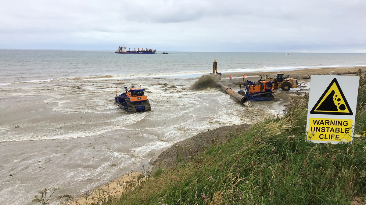
Dredged sand being pumped onshore to form sandscaping - Courtesy of Royal HaskoningDHV
The North Norfolk coastline has undergone progressive coastal erosion at around the present rate for the last 5,000 years. This long-term coastal change puts pressure on communities, infrastructure and business in the coastal zone. This includes the Bacton Gas Terminal (a piece of nationally critical infrastructure that supplies up to one third of the UK’s gas demand) and the villages of Bacton and Walcott, with approximately 300 homes, an important coastal road and associated businesses at risk of flooding and erosion.
Background
The Shoreline Management Plan (SMP) from 2012 recognised this challenge and raised awareness among the communities and other stakeholders. For Bacton Gas Terminal, the SMP states that the Bacton Terminal operators can choose to protect their assets from cliff erosion, but only if any impacts on neighbouring frontages are mitigated. This is particularly relevant for the neighbouring villages of Bacton and Walcott, where the coastline could be influenced by interventions at the terminal frontage. These villages are protected from coastal flooding and erosion by a seawall built in the 1950-60s.
Since then the beach levels have dropped significantly, increasing the seawall’s exposure. The SMP policy is to maintain the sea defences as long as economically viable, but this was only expected to be possible in the short term (around 5 to 15 years). Before the sea defences fail, measures will be required to manage the risk and mitigate the displacement of people and loss of property and facilities in the medium term.
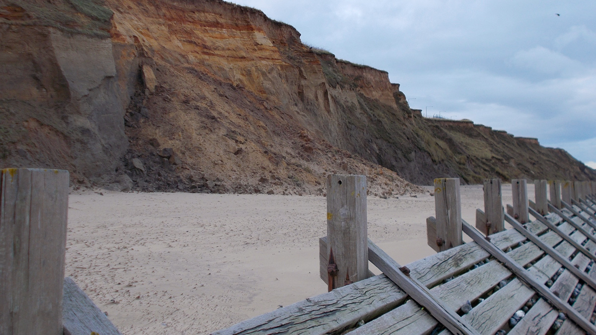
Cliff collapse and existing timber revetment – Courtesy of Royal HaskoningDHV
Story of scheme development
The December 2013 storm caused up to 10m of cliff erosion, leaving very little buffer for the terminal and its assets. The storm also caused significant flooding for the Villages and the coast road, due to wave overtopping aggravated by the low beach levels. As a result, the Bacton Terminal operators decided to develop a scheme to prevent further cliff and beach erosion. Royal HaskoningDHV was commissioned, and the initial options study concluded that a sandy solution was preferred. This would be by far the best way of preventing negative impacts to the villages and the pipelines under the beach, but it was also likely that a sandy solution could be designed to provide the robust levels of protection required for the terminal.
The next stage would be to decide between a traditional nourishment (small scale, regularly re-nourished) and a more innovative, large scale sandscaping approach. Sandscaping is inspired by the Zandmotor Project in the Netherlands, and is defined as large-scale beach nourishment, designed to work with natural processes and to achieve multiple benefits. Royal HaskoningDHV has had a leading technical role in the sandscaping initiative since 2011, and had already confirmed that this approach could work on the Norfolk coast.
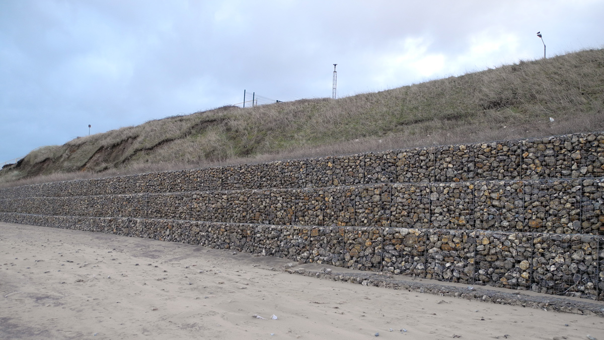
Temporary cliff stabilisation measures – Courtesy of Royal HaskoningDHV
Further option appraisal concluded that the sandscaping approach was preferable over a traditional nourishment strategy – the economy of scale benefits, potential for natural feed of sediment and wider benefits outweighed the risks associated with coastal process uncertainty and potential for social and environmental impacts.
The initial studies confirmed that a sandscaping solution could be designed to prevent negative impacts to the Villages. This raised the question whether it could also be designed to have a positive impact. This was confirmed through further work and discussion between the Bacton Terminal operators, North Norfolk District Council, the local Member of Parliament, the Environment Agency and The Crown Estate. From that point onward, the Bacton to Walcott project was developed as a combined scheme, with distinct but linked objectives, a strong and professional partnership between the clients and combined commercial arrangements.
The design was confirmed and the funding package (including an element of Government Grant in Aid for flood and coastal erosion risk reduction to the villages) was completed in the course of 2018. Planning permission and marine consent were achieved in 2018, followed by award of the contract for placement. The work is scheduled for completion in early Autumn 2019.
The Bacton to Walcott scheme also includes the replacement of the terminal’s surface water outfalls before the nourishment takes place. This is discussed in a separate submission. The focus of this paper is on the coastal management solution.
Design process
The design process was iterative (consisting of a number of option fine-tuning cycles) and consisted of three strands, as visualised above. Each element is now discussed in more detail.
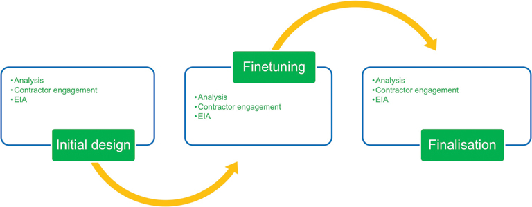
Three stages of the design process – Courtesy of Royal HaskoningDHV
Analysis: innovative use of mathematical modelling in combination with expert judgement and local knowledge: The analysis element contained significant mathematical modelling, using a range of tools and applying these in innovative ways, in combination with expert judgement and local knowledge to support client decisions.
The majority of the modelling concerned the prediction of how the shape of the beach would develop over the long term. For the terminal operators, this provided information on the functional life of the nourishment (i.e. after how many years does the erosion reach the trigger point when they need to carry out re-nourishment in order to sustain required protection levels). For the villages, the modelling results determined the prediction of the delay of seawall failure and the reduction of wave overtopping over time, which formed input into the business case for Government Grant in Aid.
Due to the scheme’s innovative nature, a single established modelling approach did not yet exist, so the intention from the start was to use multiple methods in parallel. Through the process, a combined Conceptual Model emerged as the most appropriate method; this uses the one-dimensional LITLINE model as the central engine, combining this with other tools to add the cross-sectional processes which LITLINE cannot represent.
Offshore losses toward deep water had been identified as a particular project risk, and were modelled separately (and in much detail) with a two-dimensional Area Model based on the TELEMAC-MASCARET tool. This was carried out by HR Wallingford, and its results were added to LITLINE as a sink. Area models are (in general) able to represent offshore losses, but not the known gradual onshore recovery of beaches; this element of the Conceptual Model had to be addressed through expert judgement and analysis of available historic beach profiles from the Environment Agency’s coastal monitoring programme. The resulting Conceptual Model provided a good balance of run speed and accuracy to be used as a practical design tool. Its results were translated into bespoke spreadsheets to determine the point in time when the trigger for re-nourishment would be reached, and to determine the flood and erosion benefits over time to the villages.
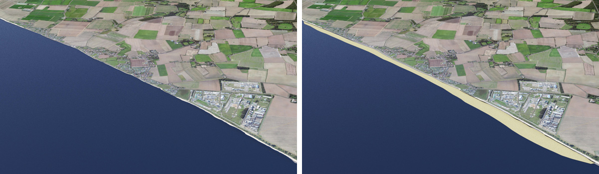
(left) Coastline before and (right) after sandscaping – Courtesy of Royal HaskoningDHV
The trigger for re-nourishment is reached when the beach no longer protects against cliff erosion. The terminal operators set a required standard of protection of 1:10,000 per year. Again, there was no established method yet for determining the beach profile that protects against cliff erosion for a defined return period. The team developed a method that combines advanced computer modelling with local knowledge.
Using recorded water level and wave information and beach profile data from historical storms known to either have caused cliff erosion or not, it was possible to use advanced wave run-up modelling tool AMAZON to determine threshold values for wave loading likely to cause erosion. AMAZON was then applied with extrapolated 1:10,000 per year conditions to determine the beach profile (crest level and width) needed to limit wave impact loading on the cliff to an acceptable value.
The resulting ‘minimum design profile’ (with safety margin) determines the Implementation Trigger for re-nourishment; an extra buffer is needed up to the Decision Trigger to provide time for the time it takes to implement a major beach nourishment.
The impact of individual severe storms is a key consideration when designing a beach nourishment. This influences the safety margin for setting the minimum design profile, but is also important for giving confidence that the nourishment will not wash away overnight. Deltares was commissioned to carry out Xbeach modelling; in addition to ‘normal’ extreme design storms, this also considered the sequential storms of 11 and 16 January 2017, in combination estimated to have a return period of over 1:10,000 per year. This showed significant but manageable beach deformation during such a severe storm; much of the moved sediment would remain in the active zone and is expected to recover; the volume lost to deep water was calculated to be in the same order as the normal annual loss. This confirms experience with the Dutch Zandmotor which was subject to the December 2013 storm, causing deformation but without significant longer term impact on beach development.
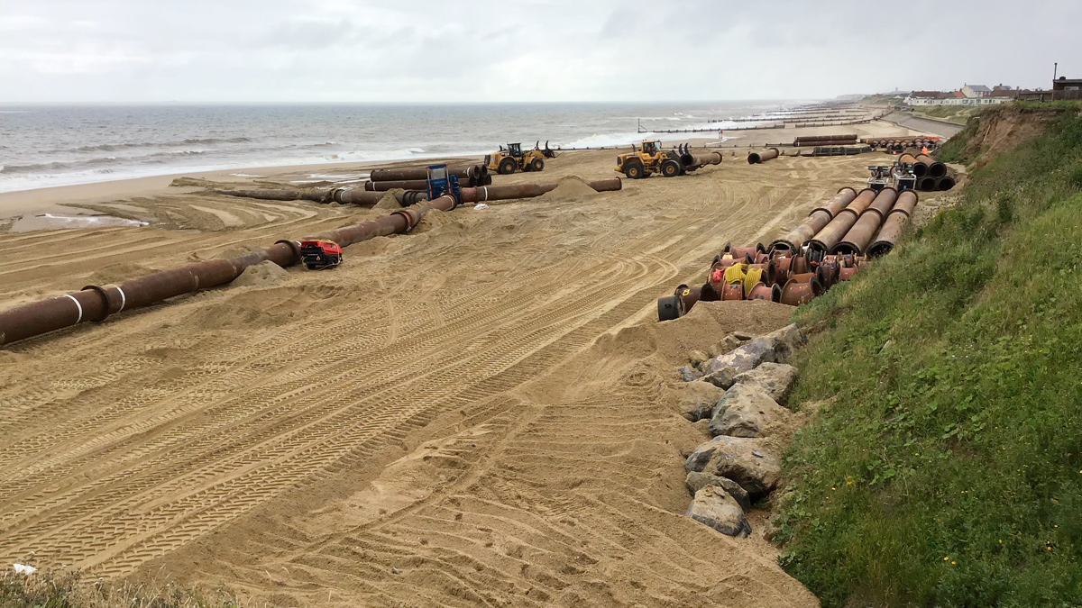
Dredge supply pipework being assembled – Courtesy of Royal HaskoningDHV
Contractor engagement: working with multiple contractors to inform design and develop high-confidence cost and programme estimates: Beach nourishment is a highly specialised operation, provided by a select number of contractors worldwide. The costs depend strongly on a complex set of variables, including bathymetry, tidal characteristics, wave climate, sediment characteristics, sediment source area and, importantly, the equipment that each contractor has available, which is commercially sensitive. In this context, strong engagement with contractors is essential, not only to generate adequately accurate cost estimates, but even more to optimise the design, in terms of maximising value for money.
Initially, the intention was to commission a single contractor for early contractor involvement. For practical reasons, a wider group of contractors was invited to provide advice and input. This has proved extremely successful and can be a template for other similar projects.
Engagement with the contractors took place at various stages. It supported key decisions in the development of the shape, size and material definition of the scheme. For example: it is known that nourishment in deeper water has a lower cost because it can be done through ‘bottom dumping’ rather than rainbowing or pumping through pipelines. As a result, a nourishment design that sticks out seaward (like the Dutch Zandmotor) could be more cost-effective, if the cost reduction due to bottom dumping balances out against the higher offshore losses. Contractor information however indicated very limited potential for bottom dumping; combined with the modelling results, this led to the decision to design a slimmer, more uniform beach profile for the Bacton scheme. Another key benefit of engaging with multiple contractors was, that the multiple budget cost estimates provided a useful range for client budgeting purposes. Finally, the exercise secured a level playing field, leading to a tender process with multiple well-informed and prepared contractors leading to high-quality bids.
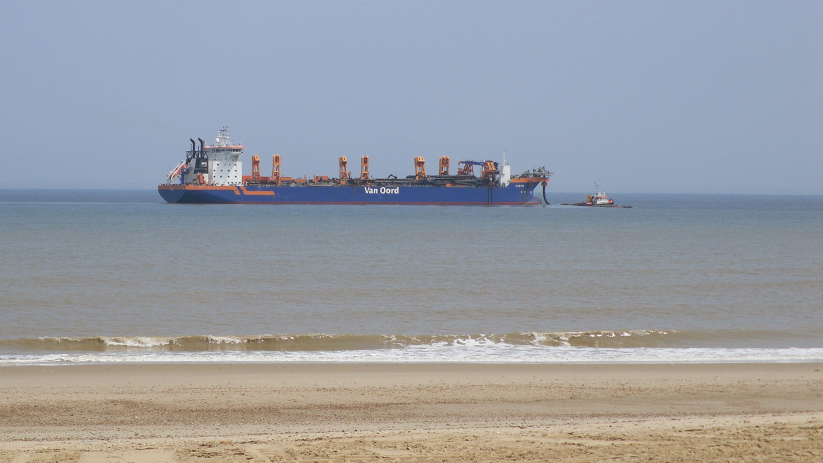
Dredger HAM 318 located offshore – Courtesy of Royal HaskoningDHV
Environmental Impact Assessment: integrated in the design process, not just at the end: Fitting with sandscaping’s philosophy of designing for multiple benefits, the team ensured that wider socioeconomic and environmental considerations played a full part throughout the design process.
This concerned the potential for impacts on designated habitats (for example, the project identified the presence of an important chalk bed near the site, which informed decisions about scheme footprint), but also wider benefits. For example, when considering the risk of wind-blown sand, the team developed the idea of dune creation on the crest of the nourishment, which is practical and affordable but could also create attractive habitats.
Bacton to Walcott Sandscaping: Supply chain
- Principal designer & EEC project manager: Royal HaskoningDHV
- Main works contractor: Team Van Oord
- Xbeach modelling: Deltares
- Two-dimensional area model: HR Wallingford
- Drone survey: MacKinnon
- Archaeological assessment of offshore geophysical data: Wessex Archaeology

Sandscaping commences – Courtesy of Royal HaskoningDHV
Resulting design and conclusions
The resulting design is a nourishment of 1.8 million cubic metres. The bulk of the material is concentrated over 2km in front of the terminal, the remainder is spread out over approximately 3.5km in front of the villages of Bacton and Walcott. In front of the terminal the beach crest will be placed at OD+7m, with a horizontal berm width up to 80m, and then sloping down to the seabed.For the villages the berm crest will be at OD+4m, up to approximately 40m wide before sloping down to the seabed. The material is similar to the existing beach material (D50 of 0.35mm), to be imported from existing licensed seabed sediment sources on the east coast. The functional life of the nourishment for the terminal is estimated at 15 to 20 years; for the villages, the scheme is expected to delay failure of the seawall by over 20 years. This time will be used to support the communities in adapting to inevitable coastal change. In addition to securing the UK’s energy supply and protecting the communities from flooding and erosion, the scheme will restore the beach to the level it had approximately 30 years ago, re-introducing the presence of a dry beach in the area.
Scheme construction started in May 2019 (outfall replacement), with beach nourishment planned to run between July and September 2019.